

Professional Construction Site Drone Photography in Calgary: The 2026 Guide
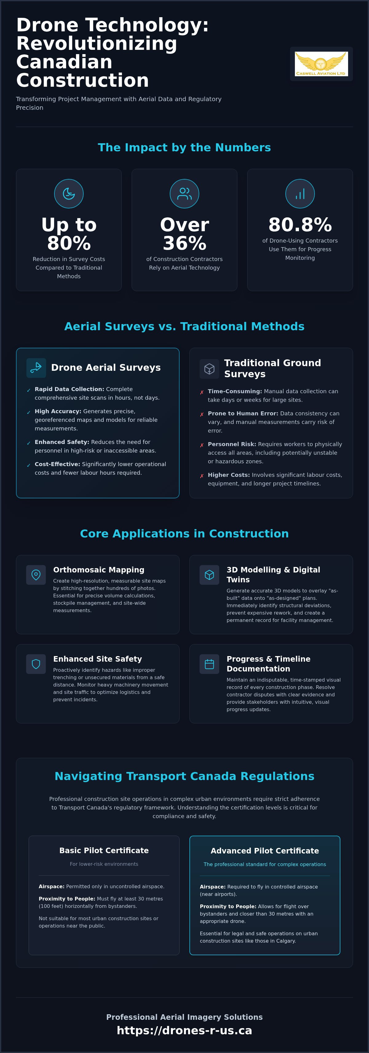
Did you know that over 36% of construction contractors now rely on aerial technology to monitor their projects, often reducing survey costs by up to 80% compared to traditional ground-based methods? You likely recognize the difficulty of tracking a massive project timeline when ground-level photos only provide a partial view. It's equally stressful to manage stakeholder expectations while navigating the anxiety of Transport Canada compliance and the risk of significant fines. Relying on inconsistent data from unqualified pilots can stall your progress and compromise site safety.
By investing in professional construction site drone photography Calgary, you can transform these operational pains into a competitive advantage. This 2026 guide explains how professional aerial imagery and strict regulatory compliance improve project management and safety across Canada. We'll examine the shift toward risk-management models in aviation, the benefits of orthomosaic mapping, and how 3D modelling provides stakeholders with total site transparency. You'll discover how a disciplined, technical approach to flight operations ensures your data is accurate, your site is hazard-aware, and your project stays firmly on schedule.
Key Takeaways
- Learn how professional construction site drone photography Calgary has transitioned from a supplemental visual tool into a safety-critical requirement for modern project oversight.
- Identify the specific advantages of orthomosaic mapping and 3D modelling for achieving precise site-wide measurements and automated stockpile analysis.
- Navigate the 2026 Transport Canada regulatory framework by understanding the differences between Basic and Advanced certification requirements for complex urban environments.
- Discover how utilizing professional flight reviewers and instructors for site operations ensures higher standards of data integrity and regulatory compliance.
Why Drone Photography is Essential for Modern Construction Management
Professional construction site drone photography Calgary is no longer defined by simple snapshots for marketing brochures. It's a systematic aerial data collection process that integrates high-resolution sensors with geospatial positioning. By 2026, the industry has realized that these flight operations provide safety-critical site data that ground-level observations cannot replicate. This shift is driven by a need for technical precision and regulatory compliance, moving drones from an optional luxury to a standard operational requirement.
Accurate aerial documentation serves as a robust tool for reducing site-wide liability. Insurance providers increasingly value the presence of regular drone surveys because they offer an objective, indisputable record of site conditions. This transparency improves stakeholder communication, as investors and clients can visualize progress without needing to be physically present. When project managers use a disciplined approach to aerial data, they create a culture of accountability that benefits the entire build team.
Enhancing Site Safety and Hazard Identification
Aerial perspectives allow safety officers to identify potential violations, such as improper trenching or unsecured materials, before they lead to incidents. Drones reduce the need for personnel to enter high-risk or unstable areas for routine inspections, which significantly lowers the probability of workplace injuries. By monitoring site traffic and heavy machinery movement from above, managers can also optimize logistical flow and prevent equipment bottlenecks. To see how these logistics are supported on the ground, check out Atlanta Container & Trailer for insights into flexible storage solutions that can be monitored via aerial survey. This proactive oversight is a core component of modern risk management.
Maintaining a permanent, time-stamped record of every construction phase is vital for long-term project health. Data from the Associated Builders and Contractors in May 2026 indicates that 80.8% of contractors using drones utilize them specifically for site progress monitoring. These records resolve contractor disputes with visual evidence of work completed at a specific date. Integrating this data into project management software allows for real-time tracking against the original build plan. This methodical approach ensures every stakeholder has access to a single, verified source of truth throughout the project lifecycle. For firms looking to implement these standards, professional drone aerial photography and video services provide the technical foundation required for high-stakes construction site drone photography Calgary operations.
Maximizing ROI with Construction Site Drone Photography in Calgary
Return on investment in the 2026 construction sector is measured by data accuracy and the speed of decision-making. Utilizing construction site drone photography Calgary provides project managers with more than just visual updates; it generates actionable technical datasets. Orthomosaic mapping allows for precise site-wide measurements that are essential for volume calculations and stockpile management. Traditional manual measurements are often slow and prone to human error, whereas drone-based data is consistent and repeatable.
Identifying structural deviations early in the build is a primary cost-saving benefit. If a foundation or structural element is misaligned, catching it via aerial inspection before the next phase begins prevents expensive rework. For pilots performing these long-duration mapping missions, ergonomic support is vital. Using Fitek Gear harnesses ensures the operator can maintain the focus and precision required for high-stakes data collection without physical fatigue.
Orthomosaic Mapping and 3D Modelling
A standard aerial photo is a flat image. In contrast, a georeferenced orthomosaic map is a composite of hundreds of images corrected for perspective and stitched together using GPS coordinates. This creates a map that is measurable and accurate. 3D models take this a step further by allowing architects to overlay "as-built" reality onto "as-designed" plans. This comparison highlights discrepancies immediately, allowing for rapid course correction. These digital twins also serve as a permanent record for facility management, aiding in future maintenance long after the initial construction ends.
Streamlining Stakeholder and Investor Reporting
Project managers can replace dense, technical written reports with intuitive visual updates. Investors appreciate a bird’s-eye view of project milestones that doesn't require a physical site visit or a safety orientation. High-resolution aerial video also creates a library of project success stories for future marketing and tendering. Utilizing professional drone aerial photography and video ensures these reports meet the highest industry standards for clarity and technical detail, reinforcing stakeholder confidence in the project's progress.
Comparing Drone Imagery to Traditional Site Surveys
Ground-based surveying remains a critical discipline, but the integration of construction site drone photography Calgary has redefined the benchmarks for speed and data density. Traditional methods often require a surveyor to walk a site with a GPS rover, manually collecting individual points. This process is time-consuming and inherently limited by the number of points a human can physically reach. In contrast, a single drone flight can capture millions of data points across an entire site in less than an hour. According to a March 2026 report from RoboticsTomorrow, companies adopting drone-based monitoring see survey cost reductions of 60-80% compared to these manual ground-based methods.
Safety is the most immediate advantage. By utilizing aerial data collection, you keep surveyors and engineers away from active heavy machinery and unstable terrain. There's no need to pause work or clear a zone for a manual survey to take place. This allows for a continuous workflow where data acquisition happens in the background without interrupting the project's critical path.
Cost-Efficiency and Resource Allocation
Drones significantly reduce the labour hours required for comprehensive site audits. Instead of waiting days for a manual survey report, project managers can receive processed aerial data within hours. This speed allows for frequent, low-cost updates. You don't have to settle for monthly snapshots; you can perform weekly or even daily site-wide checks. This frequency makes it easier to catch small errors before they become expensive structural failures. By conducting these surveys during active work hours, you eliminate the site downtime often associated with traditional measurement teams.
Data Accuracy and Integration Capabilities
Modern RPAS technology, particularly drones equipped with Real-Time Kinematic (RTK) positioning, delivers centimetre-level accuracy. This precision rivals traditional GPS rovers while providing a much richer dataset. While a manual survey provides a sparse grid of points, a drone produces a dense point cloud and a high-resolution visual map. This data integrates directly into CAD and Building Information Modelling (BIM) software environments, allowing for a seamless comparison between the digital design and the physical build. Supporting the transfer of these massive datasets often requires specialized infrastructure; for instance, Virtuser provides turnkey solutions for private 5G and LTE networks that ensure seamless connectivity on complex industrial sites.
Traditional photography lacks the embedded metadata and geospatial coordinates required for these technical engineering tasks. Professional drone aerial photography and video services ensure that every pixel is georeferenced, making the imagery a functional tool for calculations rather than just a visual reference. This technical depth is why construction site drone photography Calgary has become the preferred standard for high-precision site management in 2026.
Operating a Remotely Piloted Aircraft System (RPAS) on a job site involves more than technical skill. It requires strict adherence to federal law. Any pilot performing construction site drone photography Calgary for commercial gain must hold a valid Transport Canada drone certification. This isn't a suggestion; it's a legal prerequisite that ensures the safety of the crew and the public. In 2026, regulatory bodies have shifted toward a comprehensive risk management model, making compliance a core part of project documentation.
Distinguishing between Basic and Advanced operations is the first step for any project manager. While Basic operations might suffice for isolated rural builds, the majority of urban construction environments demand an Advanced status. This is due to the inherent proximity to bystanders and the likelihood of operating within controlled airspace. Failing to verify these credentials when hiring for construction site drone photography Calgary exposes your firm to significant legal and financial risk.
Understanding Advanced and Complex Operations
Most urban job sites require an Advanced Drone Certificate because of the "near people" rule. Transport Canada defines this as flying within 30 metres of any person not involved in the operation. Additionally, many sites sit within controlled airspace near airports or hospital helipads. In these zones, pilots must secure NAV CANADA authorization before taking off. Preparing for RPAS flight reviews is the best way to ensure your internal or contracted pilots maintain the legal standing required for these complex missions.
The Pilot’s Responsibility: Safety and Documentation
The Pilot-in-Command (PIC) holds the ultimate responsibility for the safety of every flight. This includes conducting a thorough site-wide risk assessment and completing pre-flight checklists before every launch. In a construction zone, this means coordinating with crane operators and ground crews to avoid signal interference or physical collisions. Pilots must also maintain meticulous flight logs and proof of recency. Failure to produce these documents during a Transport Canada audit can result in project delays or heavy fines. If you need to upgrade your team's credentials, you can schedule a professional flight review or advanced training session to ensure your operations remain fully compliant.
Professional Aerial Imagery Solutions from Caswell Aviation
Caswell Aviation Ltd positions itself as a comprehensive resource for the Canadian construction sector by operating as both a service provider and a national training centre. This dual role provides a unique advantage for project managers seeking construction site drone photography Calgary. When you hire pilots who also serve as Transport Canada flight reviewers and instructors, you're securing a level of technical precision and regulatory knowledge that exceeds standard industry offerings. This expertise ensures that data collection is not only high-resolution but also fully compliant with the latest 2026 aviation standards.
A holistic approach to site management often involves a blend of external services and internal capacity building. Caswell Aviation supports this by providing high-end imagery while simultaneously training your staff to manage long-term drone operations. This strategy fosters a culture of discipline and safety, ensuring that aerial data remains a reliable asset throughout the project lifecycle. By prioritizing technical mastery over flashy marketing, the brand serves as a pragmatic partner for firms that value precision and stability in their flight operations.
Certified Imagery and Site-Specific Training
Aerial photography and video packages are custom-tailored to meet specific Canadian construction standards, focusing on high-stakes data integrity. For firms looking to bring drone operations in-house, there are both online drone courses and in-person training options available. These programmes guide teams through the complexities of the 2026 regulatory environment, including specialized consultation on obtaining Level 1 Complex certification for large-scale industrial projects. This ensures that every flight conducted on your site, whether by a contractor or an employee, meets the same rigorous safety and documentation requirements.
Ergonomic Excellence with Fitek Gear
Precision site work requires more than just a capable drone; it requires an operator who can maintain focus during multi-hour mapping missions. Caswell Aviation retails Fitek Gear because a professional drone harness for smart controllers is a safety requirement rather than a simple accessory. These harnesses reduce pilot fatigue and neck strain, which is critical for maintaining steady control in challenging weather conditions. By supporting the weight of the controller, the harness allows for finer thumb movements and more accurate flight paths. This ergonomic support is essential for capturing the crisp, georeferenced imagery required for construction site drone photography Calgary, especially during the intensive data acquisition phases of a project.
Advancing Your Construction Operations with Aerial Precision
By 2026, integrating professional aerial data into your workflow is no longer an optional upgrade; it's a fundamental requirement for site safety and technical efficiency. You've seen how orthomosaic mapping and 3D modelling provide transparency that traditional ground-based surveys can't match. Maintaining strict compliance with Transport Canada regulations is the only way to protect your project from legal risks while ensuring the safety of every person on the ground.
Caswell Aviation supports your goals through a combination of high-stakes imagery and industry-leading training. With Transport Canada Advanced Flight Reviewers on staff and deep expertise in Level 1 Complex operations, we ensure your data collection meets the highest national standards. We also provide specialized Fitek Gear ergonomic harnesses to help your pilots maintain focus and precision during demanding missions.
Ready to elevate your project oversight? Book Your Professional Construction Site Imagery or Training with Caswell Aviation today. Investing in professional construction site drone photography Calgary is a proactive step toward a safer, more profitable build. We look forward to helping you master the skies and your job site.
Frequently Asked Questions
Do I need a special license to fly a drone on a construction site in Canada?
Yes, you require a Pilot Certificate from Transport Canada to operate commercially. For most urban projects, an Advanced Operations certificate is mandatory because flights often occur within 30 metres of bystanders or in controlled airspace. Pilots must pass an online exam and a flight review. This ensures the operator understands the 2026 regulatory framework and risk management protocols necessary for safe integration with ground-based construction crews and heavy machinery.
What is the difference between an orthomosaic map and a regular aerial photo?
A regular aerial photo is a single perspective image used for visual reference. An orthomosaic map is a technical dataset created by stitching hundreds of georeferenced images together. This process corrects for lens distortion and camera tilt, resulting in a map that is accurate for measuring distances and areas. These maps are essential for construction site drone photography Calgary when project managers need to calculate stockpiles or verify site boundaries in a digital environment.
How much does construction site drone photography typically cost?
The cost for professional aerial services depends on several factors, including the size of the project site, the frequency of flights, and the complexity of the data deliverables. Basic visual progress packages are generally more affordable than high-precision mapping or 3D modelling services. Most firms choose a recurring schedule to maximize the value of the data. You should request a custom quote based on your specific technical requirements and site-specific safety protocols.
Can drones fly in controlled airspace over a city construction project?
Drones can operate in controlled airspace, provided the pilot holds an Advanced Operations certificate and secures authorization from NAV CANADA. This process involves submitting a flight plan and coordinating with local air traffic control to ensure no conflict with manned aviation. Professional operators handle these logistics as part of their pre-flight planning, ensuring your project remains compliant while capturing necessary construction site drone photography Calgary data near airports or hospital helipads.
What are the insurance requirements for commercial drone pilots in Canada?
While Transport Canada regulations for drones under 25 kilogrammes don't strictly mandate liability insurance, most commercial construction contracts require it. Standard industry practice involves carrying comprehensive aviation liability coverage to protect against property damage or injury. It's critical to verify that your pilot's policy specifically covers commercial operations on active job sites, as many hobbyist policies explicitly exclude these high-risk environments. This coverage is a vital layer of risk management for any professional project.
How often should I have my construction site photographed from the air?
Most project managers find that weekly or bi-weekly flights provide the best balance of data density and cost-efficiency. This frequency allows you to track progress against the master schedule and identify structural deviations before they become expensive to fix. For high-speed phases, such as foundation pouring or structural steel erection, daily flights may be appropriate. A consistent schedule creates a reliable time-lapse record for stakeholders and future marketing efforts.
What happens if a drone pilot is not Transport Canada certified?
Hiring an uncertified pilot carries significant legal and financial consequences. Transport Canada can issue substantial fines to both the pilot and the corporation for unauthorized commercial operations. Beyond these penalties, using an uncertified operator likely voids your site's liability insurance and exposes your firm to litigation if an incident occurs. Professional certification is the only way to ensure the pilot has been vetted for technical competence and safety knowledge as per federal requirements.
Can drone data be integrated into my existing BIM or CAD software?
Drone data is designed for seamless integration with modern engineering tools. Aerial mapping software produces outputs such as 3D point clouds, digital surface models, and georeferenced TIFF files that import directly into Building Information Modelling (BIM) and Computer-Aided Design (CAD) software. This allows architects and engineers to overlay "as-built" drone data onto original design plans. This technical compatibility is a primary reason why aerial imagery has become a standard requirement for large-scale infrastructure projects.
Leave a comment