

Controlled Airspace Drone Photography in Calgary: A Professional Compliance Guide
Capturing a high-resolution sunset over the downtown skyline is a professional milestone, but it's also a high-stakes exercise in aviation compliance. When you're tasked with controlled airspace drone photography Calgary projects, the margin for error disappears. You're no longer just a photographer; you're a pilot-in-command operating within one of the most regulated environments in the country. It's common to feel a sense of urgency regarding NAV Canada authorization timelines or the looming threat of heavy fines for a single oversight. Balancing a complex safety checklist with the need for creative excellence is a challenge even for seasoned operators.
This guide provides a clear roadmap to master the regulatory requirements and technical skills needed to safely capture professional aerial imagery in controlled airspace across Canada. You'll learn how to streamline your authorization process and improve your efficiency in high-pressure urban flight environments. We'll examine the specific steps for securing NAV Canada approvals, the impact of the latest Transport Canada fee updates, and the operational habits that ensure successful delivery of high-quality aerial content. Whether you're preparing for a flight review or refining your professional workflow, this information establishes the foundation for a disciplined, compliant practice.
Key Takeaways
- Understand the distinct roles of Transport Canada and NAV CANADA to ensure your operations remain compliant with federal aviation standards.
- Learn why obtaining an Advanced Pilot Certificate is the essential first step for any professional engaging in controlled airspace drone photography Calgary projects.
- Master the submission process for Operation Authorization requests using the NAV Drone and NAV LEAN platforms to secure timely flight approvals.
- Identify technical strategies for maintaining situational awareness and pilot ergonomics in high-traffic urban environments.
- Discover how expert-led flight reviews and specialized gear like drone harnesses support long-term safety and operational precision.
Understanding Controlled Airspace for Drone Photography
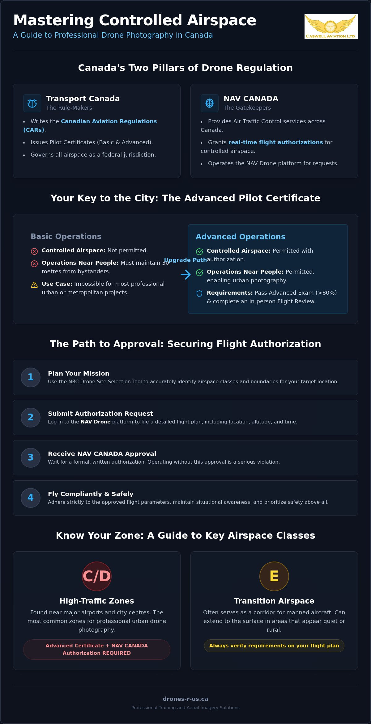
Under the Canadian Aviation Regulations (CARs), controlled airspace is defined as an area of fixed dimensions where air traffic control services are provided to ensure the safety of all flight operations. This system exists to protect manned aircraft from potential conflicts with Remotely Piloted Aircraft Systems (RPAS). For those pursuing controlled airspace drone photography Calgary, these zones aren't off-limits, but they do require a higher level of discipline and certification. Operating without authorization in these areas is a serious violation. It can lead to significant fines and the permanent suspension of your pilot privileges.
The Jurisdictional Hierarchy in Canadian Skies
A common point of confusion for new pilots is the difference between municipal bylaws and federal aviation law. While a city may control the land you stand on, Transport Canada controls the air above it. If you plan to launch from a public park, you must follow local land-use rules. However, once your drone leaves the ground, you enter a federal jurisdiction governed by Canadian Drone Regulations. This distinction is critical for urban missions where property lines and airspace boundaries overlap.
To identify these boundaries, professionals use the NRC Drone Site Selection Tool. This resource distinguishes between uncontrolled zones and those managed by NAV Canada. While Transport Canada writes the rules, NAV Canada is the entity that grants you real-time access to the sky. Professional training at Caswell Aviation helps pilots interpret these maps accurately so they don't inadvertently cross into restricted territory during a shoot.
Classes of Airspace and Their Impact on Imagery
Airspace is categorized into specific classes, each with its own entry requirements. Understanding these classes is vital for pre-flight planning and risk assessment.
- Class C and D: These are high-traffic zones found near major airports. They require an Advanced Pilot Certificate and direct written authorization from NAV Canada before you can fly.
- Class E: This is often referred to as transition airspace. It serves as a corridor for aircraft and frequently catches pilots off guard because it can extend down to the surface in areas that look like quiet suburbs or rural fields.
Professional drone photography often targets urban landmarks located deep within Class C or D zones. Without a firm grasp of these categories, you cannot build a safe flight plan or provide the technical details NAV Canada requires for an Operation Authorization. Knowing the vertical and horizontal limits of these zones ensures your creative goals don't compromise aviation safety.
Prerequisite: Obtaining Your Advanced Pilot Certificate
Flying in complex urban environments requires more than just a standard registration. For anyone serious about controlled airspace drone photography Calgary, the Pilot Certificate – Advanced Operations is the only legal pathway. A Basic Operations certificate limits you to uncontrolled airspace and requires you to maintain a distance of 30 metres from bystanders. These restrictions make it impossible to capture imagery in most metropolitan centres or near active airports. By upgrading to an Advanced certificate, you demonstrate the technical proficiency required to coordinate with air traffic controllers and operate safely near people.
Transitioning from Basic to Advanced Operations
The step from Basic to Advanced is significant. The Advanced Small RPAS Exam is a rigorous test of your knowledge of weather, theory of flight, and Canadian Aviation Regulations. Unlike the Basic exam, you must achieve a minimum 80% passing grade. This higher threshold ensures that every pilot entering controlled zones has a deep understanding of the risks involved. If you are looking for a detailed breakdown of these steps, consult The Complete Guide to Transport Canada Drone Certification in 2026. Once you pass the exam, your legal standing changes. You become eligible to request access via NAV CANADA Airspace Coordination, which is a mandatory requirement for urban missions.
The Role of the Flight Review
Passing the written exam is only half the process. To finalize your certification, you must complete an in-person flight review with a Transport Canada-qualified reviewer. At Caswell Aviation, we focus on validating your operational competency in real-world scenarios. This isn't just a skills test; it's a comprehensive check of your pre-flight procedures, emergency protocols, and site survey accuracy. Many pilots fail their first attempt because of poor record-keeping or a lack of structured checklists. Understanding What is a Drone Flight Review in Canada? will help you prepare for this final hurdle. Successfully completing this review is the gold standard for commercial photographers who need to operate in high-traffic zones. If you're ready to professionalize your operations, consider booking one of our Advanced & Level 1 Complex Flight Reviews to ensure you meet all federal standards.
The Step-by-Step Process for Airspace Coordination
Executing successful controlled airspace drone photography Calgary missions requires a methodical approach to coordination. Once you possess an Advanced Certificate, your primary tool for sky access is the NAV CANADA suite of applications. While the NAV Drone app handles many automated approvals in less congested areas, complex urban projects often require the NAV LEAN (Low Elevation UAS Network) portal. This system allows for more detailed communication with the air traffic controllers who manage the busy corridors of major cities. Professionalism in your application process is just as important as your skill behind the lens.
Submitting Your Authorization Request
A professional Operation Authorization (OA) request serves as your contract with NAV CANADA. It must be precise and conservative. Controllers prioritize the safety of manned aircraft over your creative goals, so your description must prove you understand the local environment. Use the following steps to submit a request through NAV LEAN:
- Log in to the portal: Ensure your pilot profile and drone registration details are current.
- Identify coordinates: Enter the exact Latitude and Longitude of your launch site and flight area.
- Define the buffer: Set a realistic flight radius and maximum altitude (AGL) to minimize your footprint in the sky.
- Schedule the window: Request specific start and end times, accounting for setup and teardown.
- Draft the description: Write a concise summary such as "Aerial photography of commercial tower; operation restricted to 100ft AGL; visual observers in place."
Timing is a critical factor in urban centres. While some authorizations appear quickly, you should submit requests at least 48 hours in advance. For missions near major airport approach paths, a 10-day lead time is often necessary to allow controllers to integrate your flight into their traffic management plan. Last-minute requests in these zones are frequently denied due to the lack of time for proper safety assessment.
On-Site Coordination and Communication
Your authorization may come with specific conditions, such as the requirement for two-way radio communication. To comply, you must hold a Restricted Operator Certificate-Aeronautical (ROC-A). This certification allows you to monitor local air traffic frequencies and speak directly with Air Traffic Control (ATC) if required. Use standard aviation phraseology; keep transmissions short, clear, and professional. This ensures you don't clutter the frequency used by manned aircraft.
If NAV CANADA denies or modifies your request, it is usually due to high traffic volume or conflicting manned flights. Treat a denial as a safety advisory rather than a rejection. Adjust your flight window or lower your requested altitude and resubmit. Maintaining a cooperative relationship with controllers is essential for long-term professional success. For those needing to refine their operational standards before a mission, Caswell Aviation offers the technical training required to handle these high-pressure environments with confidence.
Operational Safety and Pilot Ergonomics in Complex Zones
Executing controlled airspace drone photography Calgary missions introduces technical and physical variables not found in open fields. Pilots must manage signal interference from high-density structures and maintain a constant visual line-of-sight. Multipath interference and electromagnetic noise can degrade the link between the drone and the controller, requiring immediate corrective action. These factors demand heightened situational awareness. You're monitoring the aircraft, the telemetry, and often a radio frequency simultaneously. This mental load is significant and requires a disciplined approach to mission management.
Situational awareness isn't just about the aircraft's position. It's about the entire environment. In high-traffic zones, you must account for birds, emergency medical helicopters, and sudden gusts of wind between buildings. Pilot fatigue is a primary risk factor in these scenarios. When your neck or shoulders are strained, your reaction time slows. Your ability to execute precise movements for high-quality imagery diminishes. Safety and quality are inextricably linked to your physical state. Maintaining focus for the duration of a full battery cycle requires a level of comfort that prevents mental distraction.
Ergonomics for High-Stakes Missions
A standard neck strap is insufficient for a professional commercial session. It concentrates the entire weight of a smart controller on the cervical spine. This leads to fatigue and involuntary movements that can ruin a shot or, worse, cause a safety incident. A professional drone harness distributes the weight across the shoulders and upper back. We recommend Fitek Gear because it provides the stability required for long missions. By securing the controller against the chest, it reduces neck strain and allows for more granular control of the joysticks. This stability is essential when you're flying close to structures in controlled zones.
Safety Gear and Controller Management
Managing your equipment is a core part of maintaining a "sterile cockpit" environment. This aviation concept involves eliminating all non-essential distractions during critical phases of flight. Your smart controller must be secure and accessible at all times, never requiring you to look away from your aircraft to adjust your grip. For a deeper look at equipment selection, read our guide on Choosing the Best Drone Harness for Smart Controllers. Proper gear management ensures you can focus entirely on the mission requirements and the safety of the public. If you're looking to upgrade your operational kit, you can shop Fitek Gear drone harnesses at Caswell Aviation to improve your focus in busy urban environments.
Professional Training and Aerial Imagery Solutions
Mastering controlled airspace drone photography Calgary requirements is a continuous process that extends beyond a single flight or certificate. Professional pilots must balance regulatory knowledge with technical execution and physical readiness. Caswell Aviation supports this entire lifecycle, providing the resources needed to transition from a novice operator to a master practitioner. Whether you are looking to certify your internal team or require high-end imagery for a corporate project, our expertise ensures every mission meets federal standards. Success in this industry is built on a culture of discipline, thoroughness, and ongoing education.
Comprehensive Training and Certification
Choosing the right training format is essential for long-term retention of aviation concepts. Online drone courses offer the flexibility needed for busy professionals to master the theory of flight and Canadian Aviation Regulations at their own pace. However, in-person training provides the hands-on mentorship that is often necessary to handle complex urban environments. This direct guidance is particularly valuable when preparing for Advanced and Level 1 Complex certifications. Expert-led training sessions allow you to practice emergency procedures and site surveys under the supervision of a veteran mentor.
As regulations evolve, the Level 1 Complex certification has become a new benchmark for advanced operations. This certification is designed for pilots managing larger fleets or more intricate mission profiles. Professional mentorship accelerates your career by providing insights into the nuances of the industry that aren't found in a manual. We focus on the practical application of technology, ensuring you are prepared for the reality of high-pressure flight zones. This structured approach reduces the time spent in the learning phase and moves you more quickly into professional deployment.
High-Quality Aerial Imagery Services
For many corporations, hiring a certified professional is a business necessity rather than an option. Projects in real estate, construction, and infrastructure tracking often take place within restricted zones where the liability of non-compliance is too high. Our aerial photography and video solutions are tailored to these specific industry needs. We provide high-resolution data and cinematic content while managing all aspects of airspace coordination and safety planning. This allows your team to focus on the project results while we handle the complexities of the sky.
A certified pilot brings a level of precision that ensures the successful delivery of high-quality aerial content. This includes the use of specialized gear to maintain stability and focus during long sessions. If you are ready to elevate your operational standards or require expert imagery for your next project, the path forward is clear. You can contact Caswell Aviation for professional training or aerial services to begin your next mission with confidence. Our team is ready to partner with you to achieve safe, compliant, and exceptional results in the Canadian drone industry.
Advancing Your Professional Aviation Standards
Mastering controlled airspace drone photography Calgary is a commitment to both regulatory discipline and technical precision. Success in this field requires more than just a certificate; it demands a thorough understanding of NAV CANADA coordination and a focus on operational safety. By prioritizing pilot ergonomics and following a structured pre-flight roadmap, you can consistently deliver high-quality results in the most challenging urban environments. These standards protect your business reputation and ensure the safety of the Canadian national airspace.
Caswell Aviation provides the specialized support you need to excel in this regulated industry. We bring 25+ years of aviation industry expertise to every student and client. Our team includes a Transport Canada Advanced Flight Reviewer, and we are an official Fitek Gear retailer. Whether you're ready to finalize your certification or need professional-grade equipment for your next mission, we offer the grounded, expert guidance you deserve. Book Your Advanced Flight Review or Training Session with Caswell Aviation to elevate your operations today. We look forward to helping you reach your professional goals with confidence.
Frequently Asked Questions
Do I need a special permit to fly a drone in Calgary controlled airspace?
You must obtain an Operation Authorization (OA) from NAV CANADA and possess a Pilot Certificate – Advanced Operations. Flying without these credentials is a violation of the Canadian Aviation Regulations. For projects involving controlled airspace drone photography Calgary, the authorization process ensures your flight doesn't conflict with manned aircraft. You must submit your request through the appropriate NAV CANADA portal and wait for written approval before launching your aircraft.
How long does it take to get NAV Canada authorization for a drone flight?
Processing times vary based on the complexity of the airspace and the tools used. Automated approvals through the NAV Drone app can be near-instant in certain zones. However, manual coordination for busy urban environments typically requires a lead time of 48 hours to 10 days. Planning ahead is essential for professional missions. Last-minute requests in high-traffic areas are frequently denied because controllers need sufficient time to evaluate the safety risks.
Can I take drone photos in a city with only a Basic Pilot Certificate?
You cannot operate in controlled airspace with only a Basic Pilot Certificate. Basic operations are restricted to uncontrolled airspace and require you to remain at least 30 metres away from bystanders. Since most professional projects requiring controlled airspace drone photography Calgary occur in restricted zones, an Advanced certificate is a business necessity. Upgrading your certification allows you to legally access the sky near airports and in densely populated city centres.
What is the difference between NAV LEAN and the NAV Drone app?
The NAV Drone app is designed for rapid, often automated, flight authorizations in less complex environments. In contrast, the NAV LEAN portal is a specialized web interface used for manual coordination in high-traffic or restricted zones. Professionals use NAV LEAN when their mission requires detailed communication with air traffic controllers. Both tools are managed by NAV CANADA to ensure that every RPAS operation is integrated safely into the national civil air navigation system.
Is a flight review mandatory for flying in controlled airspace?
A flight review is a mandatory step in obtaining the Advanced Pilot Certificate required for controlled zones. You must pass a written exam and then successfully complete an in-person review with a qualified evaluator. This process validates your ability to manage emergency procedures, site surveys, and equipment checks. At Caswell Aviation, we conduct these reviews to ensure pilots meet the high standards expected by Transport Canada before they enter complex airspace.
Why should I use a drone harness for my smart controller?
Using a professional harness like Fitek Gear is a matter of safety and operational precision. Standard neck straps concentrate the weight of a smart controller on your spine, leading to fatigue and reduced reaction times. A harness distributes this weight across your shoulders, providing a stable platform for your hands. This stability is critical during long commercial sessions where you must maintain high focus to capture professional imagery without compromising your situational awareness.
What happens if I fly in controlled airspace without authorization?
Unauthorized flights in controlled zones carry severe legal and financial consequences. Transport Canada can issue heavy fines to both individual pilots and corporations for non-compliance. Beyond the financial risk, you face the permanent suspension of your pilot certificate. Most importantly, flying without authorization creates a direct collision risk for manned aviation. Professionalism requires a commitment to the rules that keep the Canadian national airspace safe for all users across the country.
Does Transport Canada require a ROC-A for all controlled airspace flights?
While Transport Canada doesn't mandate a Restricted Operator Certificate-Aeronautical (ROC-A) for every drone flight, NAV CANADA often makes it a condition of your authorization. If your flight plan requires you to monitor or communicate on aviation radio frequencies, you must hold a valid ROC-A. This certification ensures you understand standard aviation phraseology and can interact professionally with air traffic control. It is a vital credential for pilots working in high-traffic urban environments.
Leave a comment