

The Professional Guide to Real Estate Aerial Photography and Media Solutions
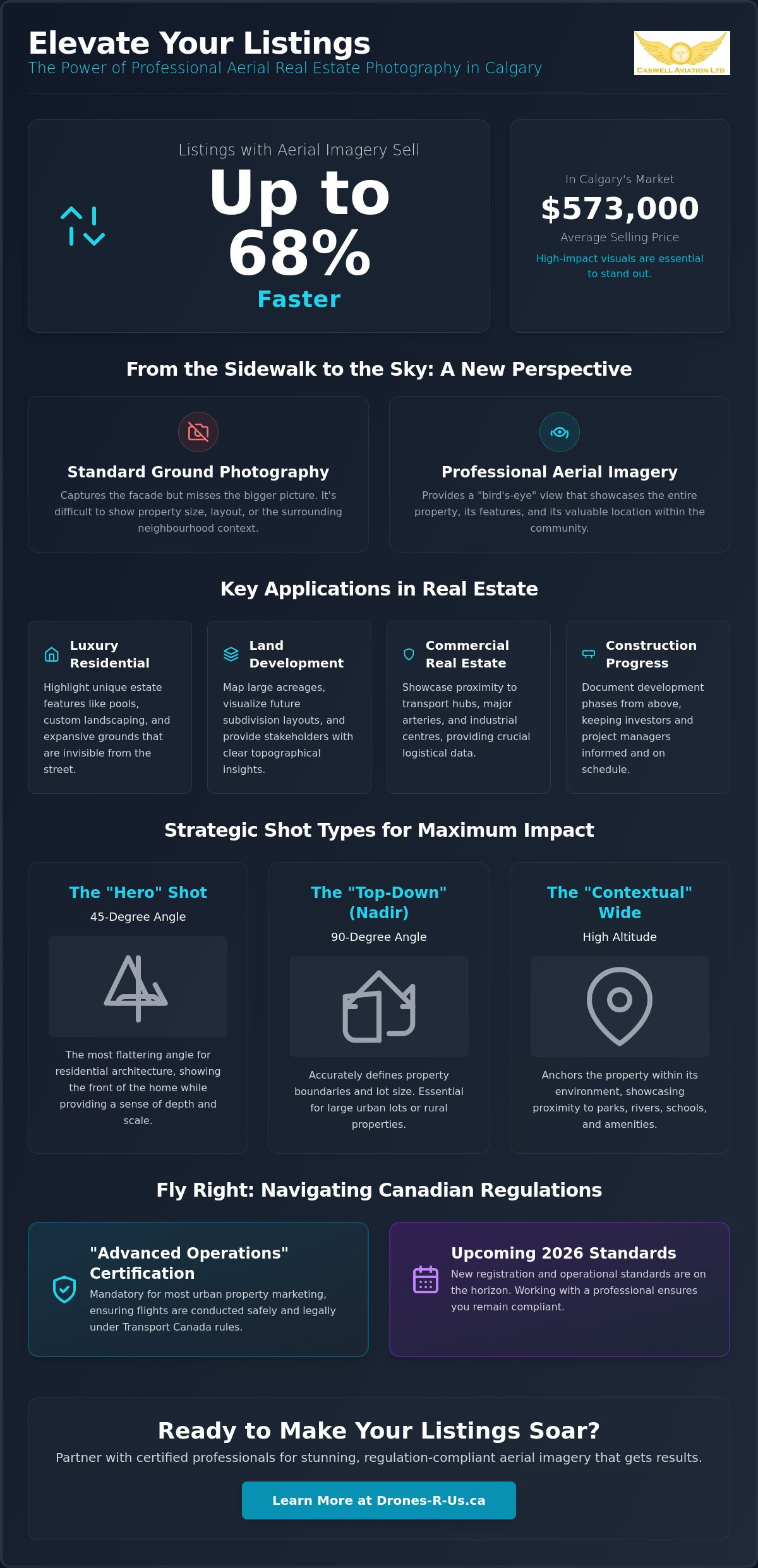
Recent data indicates that homes featuring professional aerial imagery sell up to 68% faster than those relying solely on standard ground-level photography. In a balanced market where the average selling price in Calgary remains near $573,000, high-impact visuals are essential for any listing to stand out. You likely recognize the challenge of capturing a property's full neighbourhood context or its proximity to local parks from the sidewalk. Utilizing real estate aerial photography Calgary provides that necessary perspective, but it requires a careful approach to ensure both quality and legal safety.
We've developed this guide to help you navigate the intersection of creative media and strict aviation discipline. You'll learn how professional imagery justifies premium listing prices while ensuring your operations meet all Transport Canada regulatory requirements for peace of mind. We will outline the essential certifications for urban flight, the latest 2026 registration standards, and the technical workflows that produce consistent, professional results for every client.
Key Takeaways
- Understand how aerial perspectives create comprehensive property narratives by highlighting geographic context that ground-level photos cannot capture.
- Navigate the 2026 Transport Canada regulatory framework and learn why "Advanced Operations" certification is mandatory for most urban property marketing.
- Evaluate the specific applications of real estate aerial photography Calgary for diverse projects, including luxury residential estates and complex land development mapping.
- Identify the ergonomic gear and professional hardware required to maintain image quality and pilot safety during demanding multi-site schedules.
- Determine the most efficient path for your business by comparing the costs of professional partnerships against the requirements of an in-house drone program.
The Impact of Aerial Imagery on Modern Property Marketing
Property marketing has evolved from simple documentation into a sophisticated storytelling process. In the past, ground-level photography was the primary method for showcasing a home. Today, the focus has shifted toward comprehensive lifestyle narratives. This transition reflects a deeper understanding of how buyers evaluate listings. They aren't just looking at the number of bedrooms; they're assessing how a property fits into their daily lives. Modern drone technology has played a pivotal role in this modernization, allowing professionals to capture perspectives that were previously reserved for high-budget cinematic productions.
The statistical evidence for this shift is compelling. Research indicates that homes featuring aerial images sell up to 68% faster than those with standard photos alone. In a balanced market like Calgary, where inventory levels can fluctuate, this efficiency is vital. High-quality real estate aerial photography Calgary provides the comprehensive view required to justify premium listing prices and capture buyer interest immediately. While the history of aerial photography dates back to the mid-19th century, current RPAS (Remotely Piloted Aircraft Systems) technology has made these high-impact visuals accessible for every listing level.
Defining the Competitive Edge in Urban Markets
Standing out in a saturated listing environment requires more than a standard wide-angle lens from the sidewalk. Luxury listings demand a level of sophistication that ground-level shots cannot provide. Leveraging real estate aerial photography Calgary offers a unique vantage point that distinguishes a property from the hundreds of other listings on a buyer's screen. Consistency is also a key factor. When your marketing assets maintain a high standard across still photos, video, and aerial views, it builds a cohesive brand that signals professionalism to potential sellers and buyers alike.
The Psychology of the "Bird’s Eye" Perspective
Aerial views do more than show the roof; they create a psychological sense of scale and prestige. A "bird's eye" perspective allows a viewer to grasp the entire scope of a property in a single frame. This is particularly effective for establishing the relationship between the home and local amenities. Showing a property's proximity to the Bow River, local schools, or transit hubs provides essential geographic context. This transparency reduces buyer "surprises" during physical viewings. By seeing the entire plot and the surrounding neighbourhood clearly, buyers feel more informed and confident in their decision-making process. Professional media solutions from providers like Drones-R-Us ensure these perspectives are captured safely and with technical precision.
Essential Examples of Real Estate Aerial Photography Applications
Professional aerial media is a versatile tool across several real estate sectors. For land development, it's used to map large acreages and visualize future subdivision layouts. This provides stakeholders with a clear understanding of topography and site potential before any ground is broken. In luxury residential sales, drones highlight estate features like pools, tennis courts, and custom landscaping that are often obscured at ground level. Commercial real estate benefits from showcasing proximity to major transport hubs and industrial centres. This geographic data is essential for businesses evaluating logistics and access routes. Construction progress is another vital application. Regular flights document development phases for investors and project managers, ensuring projects remain on schedule and within budget. Finally, capturing the neighbourhood context helps buyers realize the vibe of a community, looking beyond the physical structure of the home to see local pathways and nearby parks.
Strategic Shot Types for Maximum Engagement
Successful real estate aerial photography Calgary relies on specific shot compositions to communicate value. The "Hero" shot is a staple. Captured at a 45-degree angle, it shows the front of the home while providing a sense of depth and scale. This angle is generally considered the most flattering for residential architecture. The "Top-Down" or Nadir shot is used to define property boundaries and lot size accurately. This view is particularly helpful for rural properties or large urban lots where ground-level photos fail to show the full extent of the land. The "Contextual" wide shot anchors the property within its environment. By including the Calgary skyline or natural landmarks like the Rocky Mountains, you establish a sense of place that resonates with potential buyers.
Integrating Video for Immersive Property Tours
Video adds a dynamic layer to property marketing. Smooth, gimbal-stabilized cinematic fly-overs provide an immersive experience that photos cannot match. Some advanced tours now transition from exterior aerials to interior FPV (First Person View) flights, creating a seamless journey through the home. This technology is also effective for storytelling, such as illustrating a daily commute or the local lifestyle. Because these operations often take place in complex urban environments, pilots must stay current with the latest Transport Canada drone regulations to ensure safety and compliance. If you're looking to elevate your listings with these high-standard visuals, consider partnering with a provider of drone aerial photography and video to ensure professional results.
Navigating Transport Canada Regulations for Urban Operations
Operating a drone for commercial purposes in Canada requires strict adherence to the 2026 Transport Canada regulatory framework. For professionals providing real estate aerial photography Calgary, understanding these rules is a matter of legal compliance and professional liability. The regulations categorize flight operations based on risk, primarily determined by the weight of the aircraft and the proximity to bystanders or controlled airspace. Ignorance of these standards doesn't just risk a fine; it puts the safety of the public and the reputation of your business at risk.
Most real estate assignments in urban centres fall under the "Advanced Operations" category. This designation is mandatory when flying in controlled airspace or within 30 metres of people. Realtors who hire pilots with only a "Basic" certificate or no certification face significant legal risks. Transport Canada can issue substantial fines to both the pilot and the individual or agency that contracted the illegal flight. Beyond financial penalties, using an uncertified pilot often voids insurance coverage, leaving the brokerage vulnerable in the event of an accident or property damage.
There is a common misconception that sub-250g "micro-drones" are exempt from all rules. While they don't require registration or a pilot certificate for many operations, they must still be flown in a manner that doesn't endanger aviation safety or people on the ground. Professional operational discipline remains essential. Even with a small aircraft, flying in congested urban areas requires a high level of situational awareness and technical skill to avoid interference with other aircraft or local residents.
Advanced vs. Basic Pilot Certificates
A Basic Pilot Certificate is generally restricted to rural areas away from people and outside controlled airspace. Since Calgary's residential neighbourhoods are often located within controlled zones or near bystanders, an Advanced Pilot Certificate is the standard requirement for real estate work. Pilots must also coordinate with NAV CANADA to receive specific flight authorizations before launching in restricted zones. You can find more detail in The Complete Guide to Transport Canada Drone Certification.
Safety Standards and Flight Reviews
Competency is verified through a professional Advanced Flight Review, which serves as a practical assessment of a pilot's ability to handle complex scenarios. Safe urban operations also rely on robust Standard Operating Procedures (SOPs). These protocols include pre-flight checklists, site surveys, and emergency response plans. Finally, commercial liability insurance is non-negotiable. Most professional brokerages require a minimum of $1 million to $2 million in coverage to protect all parties involved in the production of real estate aerial photography Calgary.
Enhancing Operational Precision with Professional Pilot Gear
Operational success in high-stakes environments depends on the pilot's ability to maintain focus over several hours. When performing real estate aerial photography Calgary, operators often manage multiple listings in a single day. The physical demand of holding a heavy smart controller or a large tablet interface leads to muscle fatigue and reduced concentration. This fatigue is a direct threat to both safety standards and image precision. Professional media solutions require gear that supports the pilot, ensuring that the final frame of the day is as steady as the first. Maintaining peak performance is essential when navigating the complex urban airspace found in major Canadian markets.
Reducing pilot fatigue is a critical component of risk management. During complex urban flights, a pilot must monitor telemetry data, maintain visual line of sight, and manage camera settings simultaneously. If the pilot is distracted by physical discomfort, their situational awareness decreases. Utilizing professional ergonomic solutions ensures that the pilot remains comfortable, allowing them to dedicate their full attention to flight safety and creative execution. This discipline distinguishes a professional operation from an amateur one.
The Role of Ergonomics in Aerial Media
Standard neck straps are generally insufficient for the weight of modern professional smart controllers. They concentrate the load on the cervical spine, which leads to significant discomfort and restricted movement over time. A four-point harness system provides superior weight distribution across the shoulders and back, stabilizing the controller against the pilot's torso. This stability allows for more precise gimbal movements and smoother video transitions. When the controller is securely anchored, it eliminates the micro-tremors that often occur when a pilot is supporting the device's weight manually, resulting in higher quality cinematic assets.
Fitek Gear: Designed for the Professional Workflow
Fitek Gear drone harnesses are engineered specifically for the smart controllers used by industry experts. These harnesses feature adjustable straps and robust mounting points that integrate seamlessly with professional hardware. In high-stakes real estate shoots, where every second of flight time is valuable, ergonomic gear allows the pilot to focus entirely on the composition and safety of the flight path. For more information on selecting the right equipment, read our guide on Choosing the Best Drone Harness for Smart Controllers. Maintaining peak operational performance ensures that your media assets meet the high standards expected in the competitive Calgary market. Explore our full range of Fitek Gear drone harnesses for smart controllers to optimize your field workflow and enhance your technical precision.
Establishing a High-Standard Drone Program or Partnership
Real estate professionals must decide whether to outsource their media needs or develop an internal department. Establishing a high-standard program for real estate aerial photography Calgary requires more than a simple hardware purchase. It involves a commitment to ongoing regulatory compliance and technical proficiency. While an in-house team offers direct control, the true cost includes initial training, drone registration fees, and recurrent training activities required every 24 months by Transport Canada. Caswell Aviation bridges this gap by providing professional Aerial Imagery Solutions for those who prefer to outsource, while also offering the training necessary for those who wish to build their own internal capabilities.
The decision often comes down to volume and long-term strategy. For large brokerages with a high frequency of listings, an in-house team may be more efficient. However, the administrative burden of managing hardware maintenance and flight authorizations can be significant. Smaller teams or individual agents usually find that partnering with a specialized service provider offers a better return on investment. This allows the realtor to focus on client relations while the pilot handles the technical and legal complexities of the flight.
Training Your Own Media Team
To bring operations in-house, staff must obtain a Pilot Certificate, Advanced Operations. This is a prerequisite for any flight in controlled urban airspace or near bystanders. Beyond the certificate, the value of Mastering Advanced Aerial Photography Techniques cannot be overstated. A team must be equipped with professional gear, such as ergonomic harnesses, and follow established safety protocols to ensure consistent results. Investing in proper training ensures that your staff can capture high-impact visuals without compromising safety or violating federal laws.
Vetting a Third-Party Aerial Media Partner
If you choose to partner with a service provider, vetting their credentials is the first step. Ask specifically if they hold an Advanced certificate and if they have a Special Flight Operations Certificate (SFOC) if your project requires unique authorizations. Evaluate their portfolio for technical proficiency and artistic consistency. A partner who understands the local aviation landscape will navigate controlled airspace authorizations more efficiently. This ensures your real estate aerial photography Calgary project remains on schedule and meets professional standards. Before signing a contract, request a full portfolio of recent work. Verify that the pilot’s credentials are current according to the latest 2026 standards. These steps ensure that your property marketing is both high-impact and fully compliant.
Optimizing Your Competitive Strategy with Aerial Media
Integrating aerial perspectives into your marketing plan is no longer a luxury reserved for high-end estates. It's a fundamental tool for providing the geographic context and scale that modern buyers expect during their search. Success in this field requires more than just a drone; it demands a strict adherence to Transport Canada's Advanced Operations framework and a commitment to technical precision. Utilizing professional real estate aerial photography Calgary ensures your listings stand out while maintaining full regulatory compliance and safety standards in complex urban environments.
Caswell Aviation provides the expertise needed to navigate these technical and legal requirements effectively. Our team of Transport Canada Advanced Certified Pilots brings veteran-led training and operational discipline to every project. We also offer professional-grade Fitek Gear harnesses to help your own pilots maintain the stability and comfort required for long field days. Whether you're looking for high-impact media or specialized training for your staff, we're here to support your operational goals. Elevate your listings with Caswell Aviation’s professional drone services and give your clients the high-standard results they deserve. We look forward to helping you master the skies.
Frequently Asked Questions
Do I need a special licence to take real estate drone photos in Canada?
Yes, you must hold a valid Pilot Certificate issued by Transport Canada to conduct commercial drone operations. For most property marketing, an Advanced Certificate is required to fly in urban settings near people. This ensures the pilot has the necessary training to manage risks in populated areas and controlled airspace safely.
Can I fly a drone for real estate in a residential neighbourhood?
Flying in residential areas is permitted if the pilot adheres to Transport Canada's safety distances and airspace restrictions. Pilots must maintain a safe distance from bystanders and follow the rules for "Advanced Operations" if they are closer than 30 metres to people. Respecting the privacy of neighbours is also a critical professional standard during these flights.
How much does professional real estate aerial photography typically cost?
Professional rates are determined by the complexity of the flight and the volume of assets required for the listing. While basic packages focus on still photography, premium options include cinematic video and neighbourhood context shots. It's best to request a quote based on your specific listing requirements to ensure the service matches your marketing budget for real estate aerial photography Calgary.
What happens if a drone pilot crashes while shooting a property?
If a crash occurs, the pilot must follow their established emergency procedures and report the incident to Transport Canada if it meets the criteria for a reportable accident. Professional operators carry commercial liability insurance to manage the financial risks of property damage. This coverage provides peace of mind for both the realtor and the homeowner during the production.
Is an Advanced Drone Certificate required for all commercial real estate work?
An Advanced Pilot Certificate is mandatory for any operation conducted in controlled airspace or within 30 metres of people. Because residential listings are typically located in congested urban zones, this certification is essential for real estate aerial photography Calgary. Pilots must pass an advanced exam and a flight review to qualify for these complex missions.
How long does a typical real estate aerial photography session take?
Most on-site sessions are completed within 30 to 90 minutes, though complex properties may require more time. This duration allows the pilot to perform a thorough site survey and capture a variety of heights and angles. Factors like weather conditions and local airspace traffic can influence the total time spent on the property.
Can drones fly in controlled airspace near major Canadian airports?
Drones can operate in controlled airspace near airports provided the pilot has the correct credentials and NAV CANADA authorization. Pilots use the NAV Drone application to coordinate with air traffic control and ensure their flight does not interfere with manned aircraft. This coordination is a standard part of professional urban flight planning in major cities.
What is the best drone for real estate photography in 2026?
The most effective drone for real estate photography in 2026 is one that features a high-resolution sensor and meets the latest Remote ID requirements. Professionals prioritize aircraft with excellent low-light performance and stable gimbal systems for cinematic video. Choosing a drone that is compatible with professional smart controllers also allows for the technical precision required in competitive markets.
Leave a comment