
Mastering Advanced Aerial Photography Techniques for Real Estate in 2026
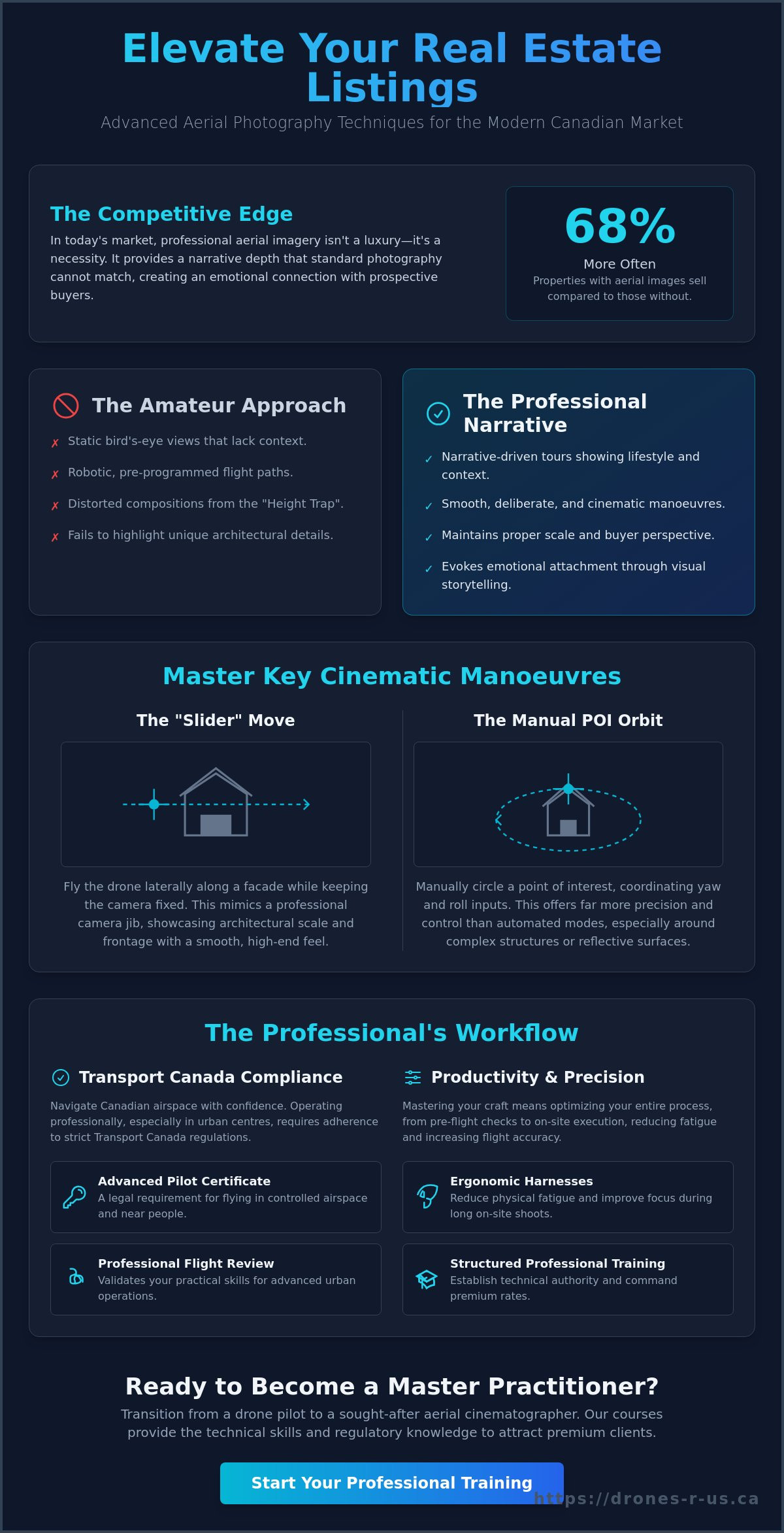
Did you know that properties featuring aerial images sell 68% more often than those without them? In the competitive Canadian market of 2026, this data from Placester highlights why mastering advanced aerial photography techniques for real estate is now a requirement for premium listings. You likely recognize that basic bird's-eye views are no longer enough to impress sophisticated clients. Many pilots struggle with distorted compositions, the stress of navigating complex Transport Canada regulations, or the physical fatigue that comes with long days on-site.
This article provides the professional path to refining your craft. You will learn the sophisticated flight manoeuvres and compositional secrets that separate industry veterans from amateurs. We promise to help you build a portfolio that attracts premium clients while ensuring you remain fully compliant and efficient. We will examine technical flight patterns, regulatory checklists for urban environments, and the ergonomic gear necessary for a more efficient workflow.
Key Takeaways
- Execute cinematic flight manoeuvres such as the POI orbit and "Slider" move to produce architectural reveals that mimic high-end camera jibs.
- Avoid the common "Height Trap" and other pilot errors by applying advanced aerial photography techniques for real estate that maintain property scale and buyer interest.
- Navigate Transport Canada regulations with confidence by securing an Advanced Pilot Certificate and completing a professional Flight Review for urban operations.
- Transition from static imagery to narrative-driven property tours that utilize specific lighting and angles to evoke emotional attachment from prospective buyers.
- Enhance on-site productivity and flight precision through the use of specialized ergonomic harnesses and structured professional training.
Beyond the Basics: Why Advanced Aerial Techniques Matter for Real Estate
The standard bird's-eye view has become a baseline expectation in the Canadian property market. To truly stand out, you must implement advanced aerial photography techniques for real estate that go beyond simple static captures. While the history of aerial photography began with fixed-wing aircraft and basic surveillance, modern technology allows for a much more intimate exploration of a property. Today, advanced work is defined by the transition from showing a roof to telling a story. You're no longer just a pilot; you're a visual storyteller providing context to a potential buyer's future life.
Buyers don't just want to see a house; they want to feel it. Automated drone modes often produce clinical, robotic movements that fail to capture the unique architectural soul of a luxury estate. These pre-programmed paths lack the nuance required to highlight bespoke stonework or the specific way light hits a west-facing terrace. Professional techniques allow a pilot to mimic the human eye's natural movement. Low-altitude orbits and slow, deliberate reveals create an emotional bridge between the viewer and the space. This level of control is what separates a technician from a master of the craft, a principle also applied by Straight Street Event Services when designing technical solutions for immersive live and hybrid events.
The Evolution of the Aerial Narrative
Narrative aerial photography is the intentional use of motion to guide a buyer's eye through a property. It's about context. Instead of just a shot of the backyard, you're showing the path from the patio to the nearby community centre or the local park. This lifestyle-centric approach helps buyers visualize their daily routine. You aren't just documenting a structure; you're selling the proximity to features that make a neighbourhood desirable. Mastering these transitions requires precision and a steady hand that automated systems simply cannot replicate.
Commercial Value and Market Positioning
Positioning yourself as a Master Practitioner requires more than just artistic flair. It demands technical discipline and a deep understanding of Canadian airspace. High-stakes commercial listings require a level of precision that basic certificates don't cover. By investing in Online Drone Courses and InPerson Training, you establish the technical authority needed to command premium rates. This differentiation is critical. In a market where many claim to be drone photographers, your ability to apply advanced aerial photography techniques for real estate sets your brand apart. Professionalism here is measured in results, safety, and the ability to execute difficult shots in tight city centres without hesitation.
Advanced Flight Maneuvers for Cinematic Property Showcases
To elevate a listing beyond the standard gallery, you must master the art of cinematic motion. Advanced aerial photography techniques for real estate rely on the pilot's ability to blend multiple axes of movement simultaneously. This creates a sophisticated feel that mimics high-budget film sets. Static shots provide information, but fluid motion provides an experience. By combining lateral flight with precise gimbal control, you can guide a viewer through a property with the steady hand of a veteran practitioner.
The "Slider" move is a foundational technique for high-end reveals. It involves flying the drone laterally along the facade of a building while maintaining a fixed camera angle. This mimics the effect of a professional camera jib or a ground-based slider rail. It is particularly effective for showcasing the scale of a large estate or a modern architectural frontage. When you execute this move, keep your speed consistent to ensure the footage remains smooth and usable in post-production.
Vertical reveals add another layer of depth. By increasing altitude slowly while tilting the gimbal down, you demonstrate the home's relationship with the surrounding horizon. This perspective helps buyers understand the property's place in the neighbourhood. Combining these vertical movements with forward flight creates a 3D sense of space that ground-level photography simply cannot replicate. It allows you to fly toward a balcony or terrace while slowly tilting the camera up to reveal the exact view the homeowner would enjoy.
Mastering the Manual Orbit
While many modern drones offer automated "ActiveTrack" modes, a professional pilot should master the manual 360-degree orbit. Automated modes often struggle with architectural corners or reflective surfaces. To perform a manual orbit, you must coordinate your stick inputs: yawing in one direction while rolling in the opposite. Start with a wide radius and a slow, predictable speed. This ensures the house remains perfectly centred in the frame throughout the rotation. Manual control allows you to adjust for wind gusts or specific features on the fly, which is a hallmark of a skilled operator.
Advanced Waypoint Mission Planning
For luxury estates, repeatability is a significant advantage. Waypoint planning allows you to set precise coordinates for altitude, gimbal pitch, and flight speed. This is essential for creating "Day-to-Night" transition shots. By flying the exact same path at sunset and again after dusk, you can blend the footage to show the property's lighting features. Ensure you integrate precise altitude data to clear obstacles like trees or power lines safely. Always remain aware of Canadian drone regulations regarding privacy and proximity during these automated missions. If you want to refine these physical stick skills under expert guidance, consider looking into Online Drone Courses and InPerson Training to reach a master level of control.
Common Drone Pilot Mistakes in Aerial Photography to Avoid
Achieving a professional standard requires more than just high-end hardware. Many operators fall into predictable traps that diminish the value of their work. The most prevalent error is the "Height Trap." While it's tempting to fly at the maximum legal limit, doing so often makes the property look small and detached from its surroundings. Advanced aerial photography techniques for real estate favour lower, more intimate altitudes that preserve the scale of the home and its connection to the streetscape. A lower perspective creates a more relatable experience for the buyer.
Ignoring the horizon is another frequent oversight. A gimbal that is even slightly unlevel or a flight path that isn't perfectly horizontal ruins the professional feel of a listing. These technical lapses signal a lack of attention to detail that premium clients will notice immediately. Similarly, proximity errors occur when a pilot remains too far away to highlight architectural details. You must get close enough to showcase high-end finishes, such as custom stonework or intricate rooflines, while maintaining a safe operating distance. By avoiding these common pitfalls, you can more effectively apply advanced aerial photography techniques for real estate to capture the true essence of a luxury home.
Timing and Lighting Missteps
Lighting is the foundation of any visual medium. Shooting with the sun directly behind the drone often results in flat, uninteresting images that lack depth. The "Golden Hour" remains the industry standard for a reason. It provides long shadows and warm tones that emphasize the texture of the building. To manage complex lighting scenarios, such as dark interiors visible through bright windows, you should utilize exposure bracketing (HDR). Midday sun is the enemy of professional real estate imagery because it creates harsh, unflattering shadows and flattens architectural depth.
Compositional and Technical Errors
Technical discipline is what separates a Master Practitioner from an amateur. Small errors in the field lead to significant work in post-production. Consider the following common mistakes:
- Fisheye Distortion: Using ultra-wide lenses without correcting barrel distortion makes straight walls look curved. This is a significant deal-breaker for luxury real estate clients who expect architectural accuracy.
- Reflections: Always check the reflection in windows or swimming pools. Including yourself, your controller, or your vehicle in the shot is a rookie mistake that breaks the immersion for the viewer.
- Wind Stability: High winds can induce micro-vibrations in the gimbal. During long-exposure shots, these vibrations lead to soft images. If conditions are too gusty, it's better to reschedule than to deliver blurry assets.
Avoiding these errors is as important as mastering new flight patterns. By refining your attention to detail, you ensure that every frame serves the narrative of the property. If you find yourself struggling with consistent results, professional Drone Aerial Photography and Video services can help bridge the gap between amateur output and master-level execution.
The Professional Workflow: Preparation and Canadian Regulations
A professional workflow begins long before the drone leaves the ground. While mastering advanced aerial photography techniques for real estate requires artistic vision, it equally demands strict adherence to the Canadian Aviation Regulations (CARs). For most real estate professionals, the Pilot Certificate – Advanced Operations is a non-negotiable prerequisite. This is because urban and suburban properties are typically located in controlled airspace or within 30 metres of bystanders. Operating without this certification can lead to significant fines, which reach up to $1,000 for individuals or $5,000 for corporations.
Obtaining this certificate involves passing the Small Advanced Exam and successfully completing a Flight Review with a qualified provider. This process ensures you possess the technical knowledge to navigate complex Canadian airspace safely. Beyond the certificate, CARs 901.27 mandates a documented site survey for every commercial flight. You must identify "micro-airspace" challenges, such as local power lines, overhanging trees, or temporary structures, that could interfere with your flight path. By integrating these regulatory requirements into your routine, you create a stable foundation for applying advanced aerial photography techniques for real estate without legal interruptions.
Transport Canada Compliance for Real Estate
Navigating controlled airspace requires coordination with NAV CANADA, typically through the NAV Drone app. Having an Advanced Certificate allows you to request these authorizations, opening doors to high-value contracts in downtown cores and densely populated urban centres. Without it, you're legally restricted from many of the most lucrative listings in the country. To understand the specific licensing steps required for your career, review the complete guide to Transport Canada drone certification in 2026.
Operational Safety and Public Relations
Safety extends beyond the aircraft. In residential neighbourhoods, managing bystander privacy and public concerns is a critical part of the job. For complex environments, employing a Visual Observer (VO) is a best practice that allows you to focus on the camera while they monitor the surrounding airspace for obstacles or other aircraft. A comprehensive pre-flight checklist ensures your RPAS is mission-ready before you arrive at the centre of the property. This discipline prevents technical delays and reinforces your reputation as a Master Practitioner. If you're ready to move into urban operations, scheduling your Advanced & Level 1 Complex Flight Reviews is the next logical step in your professional development.
Refining Your Craft with Professional Training and Ergonomics
The transition from a hobbyist to a professional pilot involves more than just a certificate. It requires a commitment to continuous improvement and the adoption of professional-grade tools. While you can learn the basics through trial and error, professional training is the fastest way to eliminate common drone pilot mistakes. Expert mentorship provides a structured environment where you can practice advanced aerial photography techniques for real estate under the guidance of a Master Practitioner. This direct feedback loop ensures that your stick movements become second nature, allowing you to focus on the creative composition of the shot rather than the mechanics of flight.
As your business grows, you will likely move from basic phone-clamped remotes to professional smart controller setups. These dedicated controllers offer brighter screens and more responsive sticks, which are essential for the high-precision manoeuvres required in luxury real estate. However, professional gear often comes with increased weight. Maintaining steady gimbal control during a long day of field operations becomes difficult if you are fighting physical fatigue. This is where ergonomics plays a vital role in your success. By addressing the physical demands of the job, you ensure that your last shot of the day is as stable and precise as your first.
Advanced Certification and Flight Reviews
Achieving a high level of proficiency requires a clear path for certification. Caswell Aviation Ltd supports pilots through the rigorous Advanced and Level 1 Complex certification process. In-person training is particularly valuable for mastering the advanced manoeuvres discussed in this guide, as it allows for real-time correction of flight patterns. Preparing for your review is a significant milestone in your career. For detailed preparation tips and a breakdown of what to expect during the evaluation, consult our Drone Flight Review guide. Expert mentorship ensures you arrive at your review with the confidence of a seasoned professional.
Maximizing Field Efficiency with Fitek Gear
Ergonomic pilot gear is a critical but often overlooked component of a professional workflow. A Fitek Gear drone harness is designed to distribute the weight of a smart controller across your shoulders rather than your neck. This prevents strain during long missions and allows for more precise thumb-stick movements. When your hands are relieved of the weight of the controller, you can execute the subtle adjustments needed for advanced aerial photography techniques for real estate with greater consistency. You can find these specialized harnesses and explore our range of Online Drone Courses and InPerson Training at Caswell Aviation Ltd. Investing in your physical comfort is an investment in the quality and safety of your flight operations.
Advancing Your Professional Drone Career
Success in the Canadian property market requires a triad of technical skill, regulatory discipline, and physical endurance. By moving beyond basic snapshots to master advanced aerial photography techniques for real estate, you position your brand as a premium partner for high-end listings. You now understand how to execute cinematic manoeuvres, avoid common compositional errors, and maintain strict compliance with Transport Canada regulations. These elements together ensure your workflow is both efficient and legally sound.
Caswell Aviation Ltd provides the expertise needed to reach this level of proficiency. Our Transport Canada Advanced and Level 1 Complex Certified Instructors offer comprehensive online and in-person training solutions tailored to your specific goals. As an official retailer of Fitek Gear professional pilot harnesses, we also provide the ergonomic tools required to maintain precision during long field operations. Master your flight skills and book your Advanced Flight Review with Caswell Aviation Ltd today. With the right training and equipment, you can navigate any urban environment with total confidence and produce results that truly stand out.
Frequently Asked Questions
What is the most common mistake drone pilots make in real estate photography?
The most frequent error is the "Height Trap," which involves flying at maximum legal altitudes. This perspective makes properties appear small and disconnected from their surroundings. Professional results require lower altitudes that preserve the architectural scale and maintain a relatable connection to the streetscape and neighbourhood context.
Do I need an Advanced Pilot Certificate to shoot real estate in Canada?
Yes, an Advanced Pilot Certificate is typically required for real estate work in Canada. Most residential listings are located in controlled airspace or within 30 metres of bystanders, which are conditions that mandate an advanced rating. Operating without the proper certificate can lead to fines of up to $1,000 for individuals and $5,000 for corporations.
What is the best height for drone photos of a residential home?
The optimal height for residential shots is generally between 10 and 30 metres. This range allows you to apply advanced aerial photography techniques for real estate by capturing the roofline and backyard while keeping the home as the focal point. Flying within this window ensures the property looks prominent rather than becoming a small part of a distant landscape.
How do I avoid drone pilot mistakes in aerial photography during windy conditions?
To maintain quality in the wind, you should increase your shutter speed and monitor gimbal stability closely. Wind induces micro-vibrations that cause motion blur in long-exposure shots. If gusts exceed your drone's specific safety rating, it's best to reschedule the shoot. Delivering sharp, professional assets is more important than completing a mission in sub-optimal weather.
Can I fly my drone in a residential neighbourhood for a listing?
You can fly in residential areas if you comply with Transport Canada regulations and have the necessary certificates. You must perform a documented site survey to identify obstacles and maintain the required safety distances from people. If the property sits in controlled airspace, you must also obtain authorization from NAV CANADA using the NAV Drone app before taking off.
What kind of drone insurance do I need for commercial real estate work in Canada?
Professional pilots should carry at least $1 million in public liability insurance. While not a federal mandate for all operations, most commercial clients and real estate agencies require proof of coverage before allowing you on-site. This insurance protects you against third-party property damage or bodily injury claims that may occur during a mission.
How does a drone harness help with photography quality?
A drone harness improves quality by offloading the controller's weight, which allows for more precise thumb-stick movements. When you aren't struggling to hold a heavy smart controller, you can execute the smooth, advanced aerial photography techniques for real estate required for cinematic reveals. This stability is critical for maintaining consistent speed during complex manoeuvres like orbits or lateral sliders.
What are the best time-of-day settings for real estate drone shots?
The "Golden Hour," occurring shortly after sunrise or before sunset, provides the best lighting for real estate. This time of day offers soft, directional light that emphasizes architectural textures and creates a warm, inviting atmosphere. You should use exposure bracketing (HDR) during these sessions to ensure you capture detail in both the bright sky and the darker shadowed areas of the property.
Leave a comment