

Professional Construction Site Drone Photography in Calgary: The 2026 Guide
What if your construction timeline wasn't just a collection of spreadsheets, but a precise, high-resolution visual record that identifies site hazards before they become costly liabilities? Managing a large-scale build in Alberta is a complex undertaking that demands absolute precision and a strict commitment to safety. You likely recognize that inconsistent data from unqualified pilots or the threat of Transport Canada fines can derail even the most organized project. Utilizing professional construction site drone photography Calgary services ensures that your aerial data is both accurate and fully compliant with the latest 2026 aviation standards.
This guide explores how professional imagery and expert flight operations transform project management from a series of guesses into a streamlined, data-driven process. You'll learn how to leverage orthomosaic maps and 3D modelling to provide stakeholders with comprehensive documentation while improving overall site safety. We will also outline the essential requirements for Transport Canada compliance, helping you avoid the risks associated with uncertified operations and ensuring your project remains on track and above board.
Key Takeaways
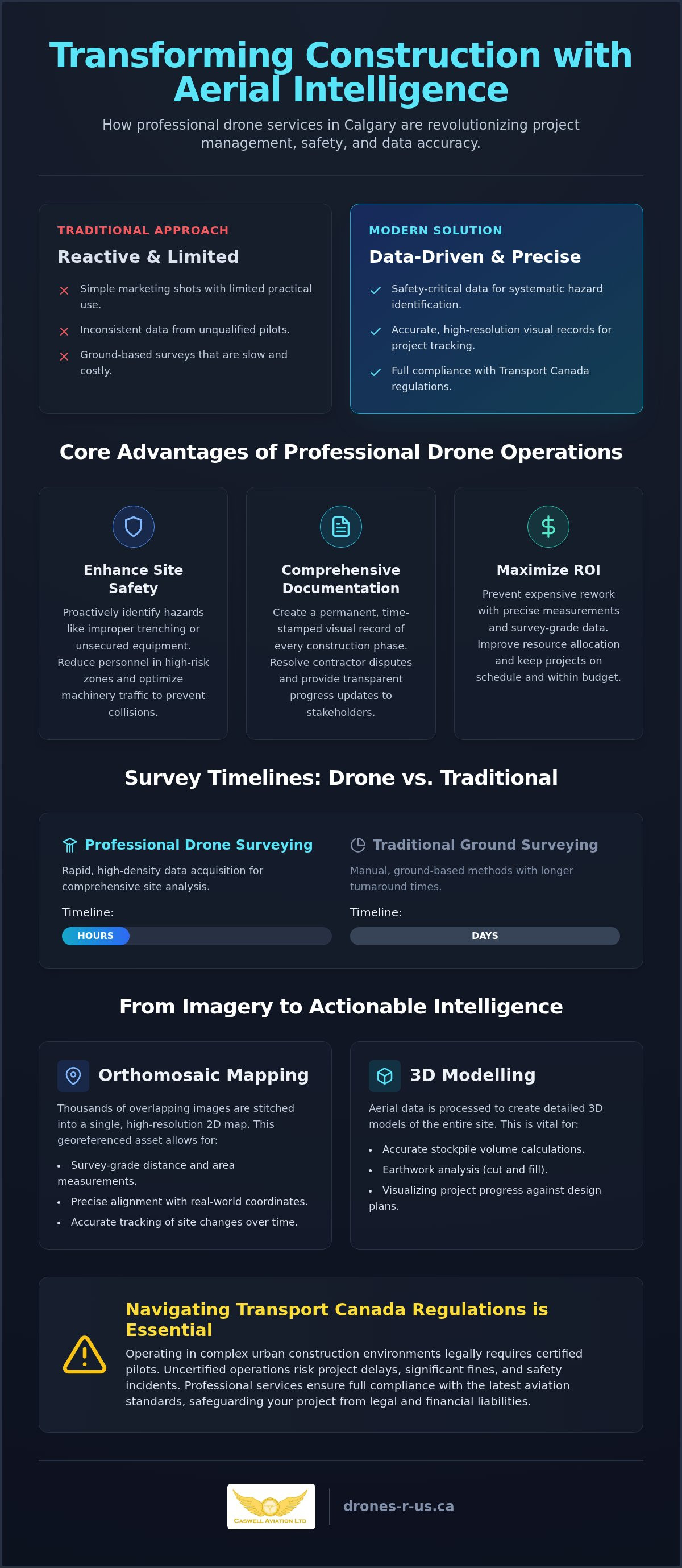
- Professional drone operations transition simple aerial imagery into safety-critical data used for systematic hazard identification and precise project tracking.
- Implementing construction site drone photography Calgary enables the use of orthomosaic mapping and 3D modelling for precise site-wide measurements and stockpile management.
- Aerial data acquisition reduces survey timelines from days to hours, providing a more cost-effective alternative to traditional ground-based surveying methods.
- Navigating Transport Canada regulations is essential for legal compliance, requiring a clear understanding of the certification levels needed for complex urban construction environments.
- Working with industry leaders who provide both operational services and professional training ensures your project benefits from advanced technical expertise and safety standards.
Why Drone Photography is Essential for Modern Construction Management
Modern construction management has moved beyond using drones for simple marketing shots. Professional construction site drone photography Calgary is now a systematic, technical process for gathering site-wide intelligence. By capturing high-resolution data from various altitudes, project managers can transform visual assets into safety-critical information. This transition allows for a proactive approach to risk management, where aerial imagery serves as a primary tool for identifying structural anomalies or logistical bottlenecks. When firms invest in professional construction site drone photography Calgary, they are not just buying photos; they are implementing a safety-critical data collection system.
The broad range of drone applications in construction includes everything from initial site surveys to final inspections. This systematic documentation helps reduce site-wide liability. Insurance providers often look favourably on projects that maintain rigorous visual records, as they provide clear evidence of safety protocols and progress. High-resolution visuals also foster transparency with stakeholders, providing them with a clear, birds-eye view of the project's health without requiring them to set foot on a busy job site. Companies looking for specialized Drone Aerial Photography and Video services benefit from pilots who understand the technical nuances of large-scale builds.
Enhancing Site Safety and Hazard Identification
Aerial perspectives allow safety officers to identify potential violations before they lead to site incidents. For instance, drones can spot improper trenching or unsecured equipment in areas that are difficult to reach on foot. By utilizing remote inspections, you reduce the need for personnel to enter high-risk or unstable zones. Monitoring the flow of heavy machinery from above also helps optimize traffic patterns, preventing congestion and reducing the risk of collisions in tight staging areas. This bird's-eye view is essential for maintaining a safe and organized work environment.
Comprehensive Visual Documentation for Timelines
Maintaining a permanent, time-stamped record of every construction phase is essential for long-term project integrity. These records provide indisputable visual evidence that can resolve contractor disputes regarding work completion or material placement. When you integrate this aerial data into modern project management software, it allows for real-time tracking against the original schedule. This level of documentation ensures that every phase of the build is documented, transparent, and legally defensible. It provides a level of certainty that ground-based photography simply cannot match.
Maximizing ROI with Construction Site Drone Photography in Calgary
Return on investment in the construction sector is increasingly tied to the quality of site data. Professional construction site drone photography Calgary provides high-density visual information that prevents expensive rework and schedule overruns. By utilizing orthomosaic mapping, project teams can take precise measurements directly from a digital interface. This process converts thousands of overlapping aerial images into a single, georeferenced 2D map with survey-grade accuracy. This level of detail allows for better resource allocation and more accurate progress tracking compared to traditional ground-based methods.
Maintaining high standards for these operations requires strict adherence to Transport Canada drone regulations. Compliance ensures that your data collection remains uninterrupted by legal complications or safety stand-downs. For pilots tasked with these long-duration mapping flights, using ergonomic equipment like Fitek Gear is essential. Professional harnesses allow for better controller stability and reduced operator fatigue, which directly translates to more consistent and precise data capture over large areas.
Orthomosaic Mapping and 3D Modelling
The difference between a simple aerial photo and a georeferenced orthomosaic map is the ability to extract actionable data. Georeferenced maps allow for precise distance and area measurements that align with real-world coordinates. This data enables 3D modelling, which is vital for volume calculations of stockpiles. Instead of relying on manual estimates for earthworks or gravel, managers receive exact figures that protect the project budget. 3D models also allow architects to compare "as-built" progress against the original "as-designed" CAD plans. Identifying a structural deviation early can save significant costs in demolition and reconstruction. Furthermore, these models serve as digital twins, providing a permanent record for facility management long after construction ends.
Streamlining Stakeholder and Investor Reporting
Stakeholder communication is often bogged down by lengthy, text-heavy reports that fail to convey the true state of a project. Professional construction site drone photography Calgary replaces these documents with intuitive, high-impact visual updates. Providing investors with a bird's-eye view of project milestones allows them to monitor progress without the logistical challenges of a physical site visit. This transparency builds confidence and streamlines the approval process for various build phases. Additionally, high-quality aerial video is an asset for future tendering. It showcases your firm's ability to manage complex sites with modern technology, giving you a competitive edge in future project bids.
If you're looking to enhance your project's data accuracy and reporting efficiency, integrating professional drone aerial photography and video is a pragmatic next step.
Comparing Drone Imagery to Traditional Site Surveys
Traditional surveying methods rely on sparse point collection. A surveyor typically walks a site with a GPS rover, capturing a few hundred points over several days. In contrast, professional construction site drone photography Calgary utilizes photogrammetry to capture millions of data points in a single afternoon. This massive increase in data density provides a granular view of the terrain that ground-based methods simply cannot match. While a manual survey might miss a small depression or a subtle pile of debris between points, an aerial scan captures every detail with centimetre-level precision. This ensures that the digital representation of your site is a true reflection of reality.
The speed of data acquisition is a primary differentiator for modern project managers. A project that takes a ground crew three days to survey can often be mapped by a drone in under two hours. While some industry competitors suggest helicopters offer speed for multiple sites, drones provide superior resolution and low-altitude flexibility that manned aircraft can't match. This efficiency reduces the cost-per-acre significantly. It also improves site safety by keeping personnel away from active work zones. You don't need to send staff into areas where heavy machinery is operating or onto unstable slopes. Aerial mapping is non-intrusive; it allows the build to continue without the downtime typically required for ground-based measurements.
Cost-Efficiency and Resource Allocation
Drones significantly reduce the labour hours required for comprehensive site audits. Instead of paying for a large crew to spend days on-site, a single pilot can execute the mission. This lower cost allows for more frequent updates. Rather than waiting for a monthly survey, managers can request weekly scans to monitor progress. This frequency ensures that any deviations are caught immediately, allowing for better resource allocation and preventing expensive delays. By identifying issues early, you avoid the high costs of corrective construction later in the project timeline.
Data Accuracy and Integration Capabilities
Modern construction site drone photography Calgary relies on Real-Time Kinematic (RTK) technology to ensure survey-grade results. RTK-enabled drones communicate with base stations to provide centimetre-level accuracy without the need for extensive ground control points. This high-quality data is ready for immediate use in professional workflows. It integrates seamlessly into CAD and BIM software environments, allowing engineers to overlay current site conditions on top of original plans. Traditional photography lacks the georeferenced metadata required for these engineering tasks. Without this metadata, photos are just pictures; with it, they are precise measuring tools. For those looking to implement these systems, professional drone training ensures your team can handle this complex data with precision.
Navigating Transport Canada Regulations for Construction Site Operations
Compliance with federal aviation law isn't optional for any commercial aerial operation. For construction site drone photography Calgary, this means every pilot must hold a valid certificate issued by the federal government. Operating a drone for business purposes without the correct Transport Canada drone certification is illegal and exposes project managers to significant liability. Beyond the legal requirements, professional pilots must maintain comprehensive liability insurance and adhere to site-specific safety protocols that align with existing occupational health and safety standards. This regulatory framework ensures that your project remains protected from both physical incidents and legal penalties.
Understanding Advanced and Complex Operations
Urban construction environments present unique challenges that typically move a mission from Basic to Advanced status. Most projects in developed areas require an Advanced Drone Certificate because the flight path often occurs within 30 metres of bystanders or inside controlled airspace. Flying near airports or hospital helipads requires specific NAV CANADA authorizations, which only advanced pilots can obtain. Achieving this status involves passing a rigorous online exam and completing one of the mandatory RPAS flight reviews conducted by a qualified reviewer. This process ensures the pilot possesses the practical skills to manage technical failures or emergency procedures in high-stakes environments where precision is non-negotiable.
The Pilot’s Responsibility: Safety and Documentation
A professional pilot functions as the pilot-in-command, bearing full responsibility for the safety of the airspace and the people below. This role begins long before takeoff with a detailed site-wide risk assessment and a pre-flight checklist. In a construction zone, this includes identifying hazards like cranes, power lines, and active machinery. The pilot must also coordinate communication with site crews to ensure the drone's presence doesn't interfere with ground operations. Maintaining accurate flight logs and pilot recency records is a mandatory part of the regulatory framework. These documents provide a transparent audit trail that proves the operation remained compliant with all safety standards. Professional documentation is the hallmark of a veteran pilot who values discipline over speed.
Precision and safety are the foundations of any successful build. If your team needs to upgrade their skills or secure a compliant flight reviewer, you can book your Advanced Flight Review with our veteran instructors today. We provide the technical training required to ensure your operations meet the highest standards of Canadian aviation law.
Professional Aerial Imagery Solutions from Caswell Aviation
Caswell Aviation Ltd operates at the intersection of high-stakes aviation and modern construction technology. We don't just provide aerial data; we establish the safety and operational standards for the entire industry. This dual role as a service provider and a Transport Canada-qualified training centre gives our partners a distinct advantage. When you engage us for construction site drone photography Calgary, you're working with pilots who also serve as professional flight reviewers and instructors. This deep expertise ensures every mission is executed with technical precision and total regulatory compliance.
Our approach focuses on long-term project success. While high-end imagery provides immediate value, we also offer the training required for firms to bring these capabilities in-house. We advocate for a holistic strategy that combines professional-grade data collection with a culture of aviation discipline. This ensures that your team isn't just flying drones, but managing a sophisticated aerial data system. By combining our specialized services with internal capacity building, your firm can maintain a competitive edge in an increasingly digital industry.
Certified Imagery and Site-Specific Training
We provide custom aerial photography and video packages designed specifically for Canadian construction standards. These deliverables range from high-resolution progress photos to complex 3D models and orthomosaic maps. For firms looking to internalize these operations, we offer both in-person and online training options. Our consultation services also guide large-scale industrial projects through the requirements for Level 1 Complex certification. This ensures your internal teams are prepared for the most demanding operational environments in the country, from high-density urban builds to remote infrastructure projects.
Ergonomic Excellence with Fitek Gear
Precision in the field requires more than just a capable aircraft; it requires a pilot who can maintain absolute control for extended periods. We believe a professional drone harness for smart controllers is a safety requirement rather than a simple accessory. During multi-hour site mapping missions, pilot fatigue becomes a genuine safety risk. Fitek Gear is engineered to distribute the weight of heavy smart controllers across the torso, reducing strain on the neck and shoulders.
This ergonomic support allows for steadier, more precise control during high-resolution data capture. It's particularly vital when operating in challenging Canadian weather conditions where wind and cold demand a pilot's full attention. By utilizing professional-grade harnesses, your operators can focus entirely on the mission at hand, ensuring the data captured is consistent and accurate. Investing in the right gear is an investment in site safety and data integrity.
Future-Proofing Your Construction Projects with Aerial Intelligence
The integration of professional construction site drone photography Calgary marks a significant shift in how projects are managed and secured. By moving beyond simple imagery toward high-density orthomosaic mapping and 3D modelling, your firm can achieve survey-grade accuracy while reducing site-wide liability. Maintaining strict Transport Canada compliance and utilizing ergonomic tools like Fitek Gear ensures that your aerial operations remain both legal and efficient throughout the project lifecycle.
Caswell Aviation Ltd provides the technical authority required to manage these complex missions. With Transport Canada Advanced Flight Reviewers on staff and deep expertise in Level 1 Complex operations, we offer a level of precision that hobbyist pilots cannot match. Whether you need comprehensive visual documentation or professional training to build your internal capacity, we are ready to assist. Book your professional construction site imagery or training with Caswell Aviation Ltd today to ensure your next project is backed by industry-leading expertise. We look forward to helping you elevate your site standards and project transparency.
Frequently Asked Questions
Do I need a special license to fly a drone on a construction site in Canada?
Yes, any person operating a drone for commercial purposes in Canada must hold a Pilot Certificate from Transport Canada. For most urban projects, an Advanced Pilot Certificate is mandatory because these sites often fall within controlled airspace or near bystanders. Utilizing professional construction site drone photography Calgary ensures that your pilot has the necessary legal standing and training to operate safely and legally within these complex environments.
What is the difference between an orthomosaic map and a regular aerial photo?
A regular aerial photo is a single perspective of a specific area. An orthomosaic map is a georeferenced image created by stitching together hundreds of overlapping photos. These maps are corrected for lens distortion and topographic variations to ensure a consistent scale across the entire site. This allows project managers to perform precise measurements of distance and area directly from the digital file, which is not possible with standard photography.
How much does construction site drone photography typically cost?
The cost of aerial services depends on several factors, including the size of the project, the frequency of flights, and the required data outputs. Basic visual updates are generally less expensive than technical deliverables like 3D modelling or orthomosaic mapping. While industry rates for professional pilots vary based on expertise and equipment, investing in a qualified operator prevents the significant costs associated with data errors or regulatory fines.
Can drones fly in controlled airspace over a city construction project?
Drones can operate in controlled airspace, but the pilot must hold an Advanced Pilot Certificate and obtain specific authorization from NAV CANADA. This process involves coordinating with air traffic control to ensure the flight does not interfere with manned aviation. Professional operators handle these authorizations as part of their pre-flight planning, ensuring that construction site drone photography Calgary remains compliant and safe even in busy urban environments.
What are the insurance requirements for commercial drone pilots in Canada?
Transport Canada does not strictly mandate liability insurance for all drone operations, but it is an essential requirement for commercial work on construction sites. Most project owners require pilots to carry at least $1 million to $5 million in specialized drone liability insurance. This coverage protects against property damage and bodily injury, providing a necessary layer of financial security for both the pilot and the contracting firm.
How often should I have my construction site photographed from the air?
The frequency of aerial documentation is determined by the project's pace and reporting requirements. Many firms opt for weekly or bi-weekly flights to track progress against the schedule and monitor material stockpiles. For long-term documentation, a monthly flight may suffice to provide stakeholders with a high-level overview. Consistent data collection allows for better chronological records, which are invaluable for resolving contractor disputes or identifying safety trends over time.
What happens if a drone pilot is not Transport Canada certified?
Hiring an uncertified pilot is a violation of Canadian aviation regulations and carries significant risks. Transport Canada can issue substantial fines to both the pilot and the company that hired them. Additionally, most insurance policies are voided if the operator does not hold the proper certification. Operating without a certificate compromises site safety and exposes your firm to legal liabilities that far outweigh the cost of hiring a professional.
Can drone data be integrated into my existing BIM or CAD software?
Yes, professional drone data is designed for seamless integration into modern BIM and CAD software. Standard outputs such as georeferenced TIFFs and 3D point clouds allow engineers to overlay current site conditions onto original design plans. This capability is essential for identifying structural deviations and managing as-built documentation. Using high-quality aerial data ensures that your digital twin remains accurate and useful for long-term facility management.
Leave a comment