

Professional Aerial Inspection Services: A 2026 Reference Guide to Standards and Efficiency
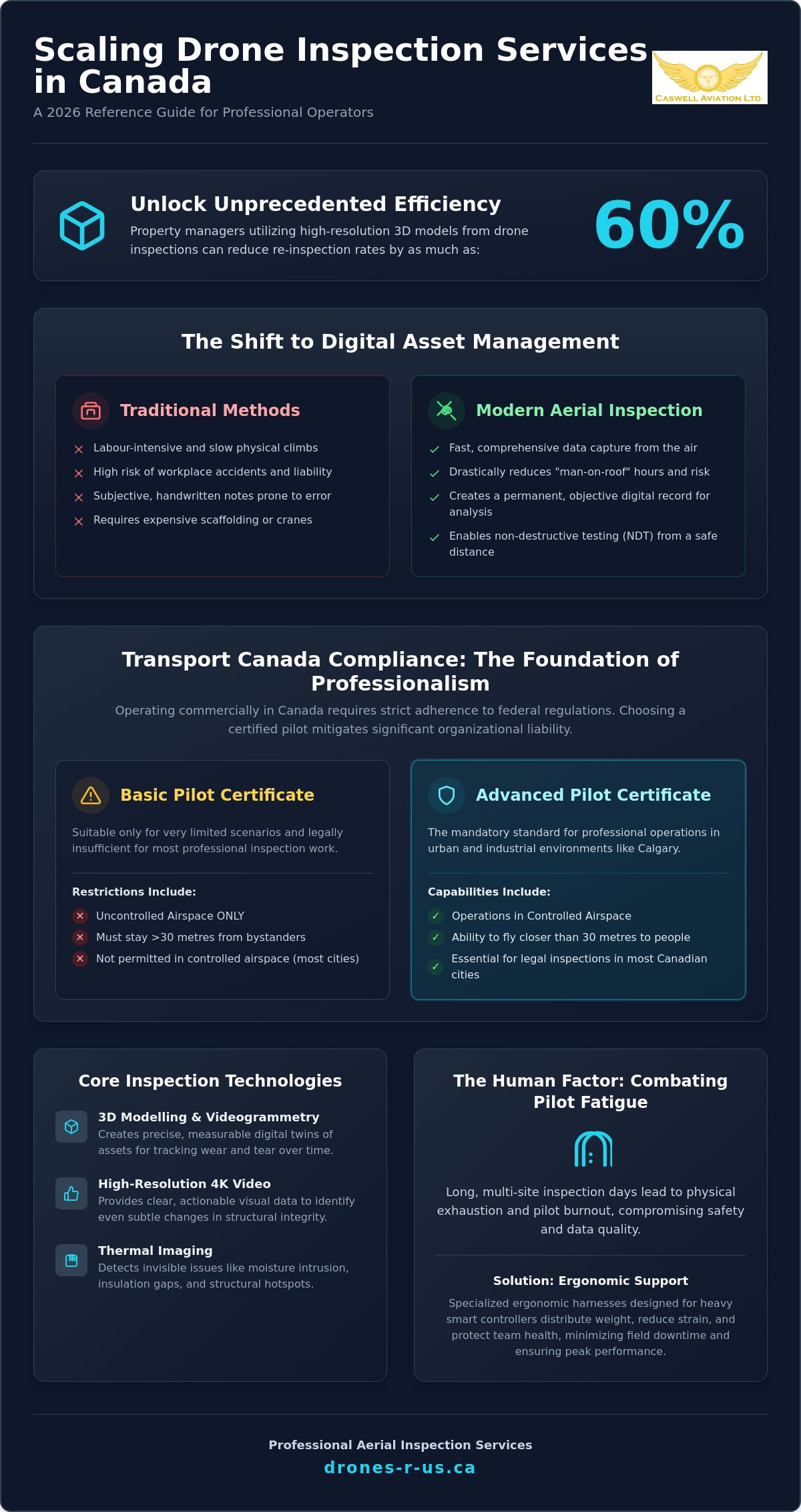
Did you know that property managers utilizing high-resolution 3D models can reduce their re-inspection rates by as much as 60%? For those providing drone roof inspection services, this statistic highlights the growing demand for precision and professional-grade data in a competitive market. Most operators realize that capturing images is only the first step. The real difficulty lies in maintaining strict Transport Canada compliance while managing the physical exhaustion that often sets in during complex, multi-site inspection days.
At Caswell Aviation Ltd, we understand that you want to deliver high-resolution, actionable data without the headache of regulatory confusion or pilot burnout. This 2026 reference guide provides the technical and ergonomic essentials you need to scale your operations efficiently across Canada. You'll learn about the latest Advanced certification requirements, the shift toward thermal imaging and videogrammetry, and how professional gear like ergonomic harnesses can protect your team's health. We've organized this information to help you achieve full compliance and minimize field downtime, ensuring your aerial services remain both profitable and safe.
Key Takeaways
- Understand why a Transport Canada Advanced Pilot Certificate is mandatory for operations in controlled airspace and how it mitigates organizational liability.
- Discover how transitioning to digital data collection through thermal imaging and 3D modelling improves accuracy for industrial and commercial building assessments.
- Identify the specific standards required for a professional drone roof inspection Calgary to ensure you receive high-resolution, actionable data from every mission.
- Learn how to combat pilot fatigue during long field days by utilizing specialized ergonomic harnesses designed for heavy smart controllers.
- Evaluate the role of professional flight reviews and training programs in scaling your internal aerial inspection capabilities with safety and precision.
Understanding the Value of Aerial Inspection Services
Aerial inspections represent a sophisticated application of unmanned aerial vehicle technology, technically classified as Remotely Piloted Aircraft Systems (RPAS). This technology replaces the traditional, labour-intensive method of physical climbs with advanced sensors that capture comprehensive data from the air. For many commercial property managers, a drone roof inspection Calgary service provides a level of detail that was previously impossible to achieve without expensive scaffolding or industrial cranes. By removing the need for human personnel to occupy high-risk positions, companies realize significant gains in both operational speed and data quality.
The transition from manual inspections to digital data collection creates a foundation for repeatable, objective analysis. Unlike a technician's handwritten notes, which can vary based on individual perspective or fatigue, aerial imagery produces a permanent digital record. This capability allows for precise tracking of wear and tear over time. You can compare images from different years to identify subtle changes in structural integrity, ensuring that maintenance decisions are based on empirical evidence rather than rough estimates. This bird's-eye perspective offers a holistic view of an asset, revealing patterns of damage or drainage issues that are often missed from the ground or during a standard walk-through.
The Shift to Digital Asset Management
Modern asset management relies on the integration of high-resolution 4K video and thermal sensors to identify anomalies before they become catastrophic failures. These sensors detect moisture intrusion, insulation gaps, and structural hotspots that remain invisible to the naked eye. Professionals now integrate this drone-captured data directly into corporate asset management workflows. This systematic process allows for preventative maintenance scheduling based on actual condition reports. It helps organizations optimize their long-term capital expenditure by addressing minor issues before they require full-scale replacements.
Safety and Risk Mitigation Standards
Safety remains the primary driver for adopting aerial technology in industrial environments. By reducing "man-on-roof" or "man-on-scaffold" hours through remote sensing, organizations drastically lower their liability and the potential for workplace accidents. Pilots can inspect hazardous areas, such as high-voltage lines, chemical vents, or unstable structures, from a safe standoff distance. Aerial inspection is formally defined as a non-destructive testing (NDT) method because it allows for thorough structural evaluation without causing physical impact or damage to the asset. This approach ensures that a drone roof inspection Calgary project remains efficient while maintaining the highest safety standards for all personnel on the job site.
Transport Canada Compliance: The Foundation of Professional Inspections
Operating a drone for commercial purposes in Canada isn't just about pilot skill; it's about legal adherence to Transport Canada drone regulations. For any drone roof inspection Calgary project, the location usually falls within controlled airspace due to the proximity of the Calgary International Airport and Springbank Airport. This environment mandates that the pilot holds an Advanced Pilot Certificate. Hiring an uncertified operator doesn't just result in poor data quality; it exposes your organization to significant liability and heavy federal fines. A certified professional acts as a safety safeguard, ensuring that all flight operations meet rigorous federal standards before the aircraft even leaves the ground.
The distinction between Basic and Advanced operations is vital for industrial and residential sites alike. Basic certificates are restricted to uncontrolled airspace and require the pilot to stay at least 30 metres away from bystanders. In contrast, urban environments and complex industrial facilities frequently require closer proximity to buildings and people. Without an Advanced certificate and the appropriate flight permissions, an operator is legally unable to perform most inspections in Calgary's residential or commercial hubs. For a deeper look at these specific requirements, you can read The Complete Guide to Transport Canada Drone Certification. Ensuring your pilot is properly rated protects your project from being grounded by regulatory authorities.
Advanced and Level 1 Complex Certification
A "Complex" operation typically involves flying within 30 metres of people or operating in heavily restricted zones. Maintaining these high operational standards requires regular professional flight reviews to verify technical competency. Because Caswell Aviation operates as a dedicated training provider, our background ensures that pilots are prepared for the unpredictable variables of real-world industrial sites. This veteran-mentor approach to training guarantees that every mission is executed with the discipline required for high-stakes environments.
Regulatory Recency and Safety Documentation
Pilot certificates remain valid only if the holder meets specific recency requirements. In Canada, pilots must complete a recurrent training activity every 24 months to keep their certificate valid. Professional reporting also depends on meticulous site surveys and flight logs, which provide a legal paper trail for every inspection conducted. You can stay updated on the latest 2026 rules by reviewing our guide on Drone Regulations in Canada. If you're planning a project and need to verify compliance standards, our team can help you review your operational requirements to ensure a safe, legal flight.
Critical Applications for Drone-Based Inspections
The versatility of Remotely Piloted Aircraft Systems (RPAS) allows for high-precision data collection across several sectors. While a drone roof inspection Calgary service is a common request for residential and commercial buildings, the technology extends into heavy industrial and infrastructure monitoring. For bridges, pipelines, and power lines, drones provide a safe method to monitor structural health and identify corrosion or mechanical wear. These missions often take place in environments where traditional access is either too dangerous or logistically impossible. By deploying drones, organizations can maintain continuous oversight of their most critical assets without pausing operations.
In the commercial real estate sector, detailed assessments of facades and building envelopes are now standard. Drones capture high-resolution imagery that reveals cracks, spalling, or drainage issues that ground-level observations miss. Construction teams also utilize this technology for progress tracking through orthomosaic mapping and volumetric analysis. These tools allow project managers to calculate the volume of stockpiles or verify that site grading matches the original design specifications. In the telecommunications industry, drones facilitate thorough tower inspections. Technicians can identify equipment failures or alignment issues without the need for dangerous, time-consuming climbs.
Thermal and Infrared Analysis
Thermal sensors provide a layer of data that visual cameras cannot replicate. In Calgary's fluctuating climate, detecting moisture entrapment in flat roofs is essential for preventing long-term structural damage. Radiometric sensors capture precise temperature measurements, allowing professionals to identify heat loss in building envelopes or electrical "hot spots" in industrial machinery. This data is invaluable for preventative maintenance. It allows you to pinpoint exact areas of concern, ensuring that repairs are targeted and cost-effective rather than based on broad generalizations.
High-Resolution Visual Mapping
Visual mapping transforms raw images into actionable 2D maps and 3D models. These digital twins are used for site planning and provide stakeholders with clear, visual updates on project status. By documenting "as-built" conditions, companies can compare current site progress directly against original blueprints to identify discrepancies early. The level of detail available is exceptional. High-powered zoom lenses allow for bolt-level inspections from a distance, which ensures that structural fasteners are secure without requiring a physical climb. This combination of macro-level mapping and micro-level detail makes aerial photography an essential tool for modern asset management.
Maximizing Field Efficiency with Ergonomic Pilot Gear
High-stakes aerial inspections require more than just technical certification and high-resolution sensors. They require physical endurance from the operator. Pilot fatigue is a significant but often overlooked factor that directly impacts inspection accuracy and site safety. During a full day of performing a drone roof inspection Calgary project, a pilot may spend several hours staring at a screen while supporting the weight of a heavy smart controller. When physical exhaustion sets in, fine motor control diminishes and the likelihood of missing a critical structural defect increases. Maintaining a high standard of data collection requires tools that support the pilot's physical well-being throughout the entire mission.
Standard neck straps are fundamentally insufficient for professional-grade hardware. Most smart controllers used in industrial settings weigh significantly more than hobbyist remotes. A simple strap concentrates this entire load on the C7 vertebrae, leading to chronic neck strain and shoulder tension. This discomfort forces pilots to take frequent breaks, which increases field downtime and reduces overall operational efficiency. Professional operators realize that the right support system is a prerequisite for success. For a detailed comparison of available options, you can consult our guide on Choosing the Best Drone Harness for Smart Controllers.
The Ergonomics of Long-Duration Flights
Effective ergonomics start with weight distribution. A professional harness, such as those from Fitek Gear, redistributes the controller's weight across the shoulders and upper back. This stability allows for improved fine motor control, which is essential when navigating a drone close to building envelopes or industrial assets. A secure harness also provides "hands-free" capability. This feature allows pilots to safely manage site paperwork, adjust PPE, or consult a tablet without the risk of dropping expensive flight hardware. These small efficiencies accumulate over a long day, resulting in more completed inspections with less physical toll on the team.
Fitek Gear for Professional Smart Controllers
Fitek Gear is the established professional standard for pilots who utilize DJI Smart Controllers and other rugged, enterprise-grade hardware. These harnesses are built to withstand the demanding conditions of Canadian field environments, from the high winds of the prairies to the temperature fluctuations of the Alberta foothills. Durability is a core requirement; professional gear must survive constant use in dusty, industrial settings without failure. Experienced pilots view ergonomic equipment not as a luxury, but as a critical investment in safety and long-term career health. If you are looking to upgrade your field kit, you can explore our range of Fitek Gear harnesses to find the right fit for your specific controller model.
Implementing Professional Aerial Solutions for Your Operations
Deciding between hiring a third-party service provider or building an in-house drone department is a strategic choice for many Canadian firms. For organizations navigating these complex transitions, Formatour Incorporated offers advisory services focused on strategic transformation and operational performance. For a one-off drone roof inspection Calgary project, hiring an external professional is often the most cost-effective route. It eliminates the immediate need for hardware investment, specialized insurance, and ongoing pilot training. However, organizations with high-frequency inspection needs in the industrial or commercial sectors often realize long-term benefits from developing internal capabilities. This transition requires a structured approach to training and certification to ensure safety standards remain consistent across all field operations.
Caswell Aviation Ltd supports both operational models. We provide professional aerial imagery for immediate project needs while offering the technical training required to build a competent in-house team. This dual approach allows you to scale your aerial program at a pace that matches your budget and project volume. When you choose to build internally, we act as a veteran mentor to help you establish a culture of discipline and compliance.
Selecting the right partner for your aerial operations is critical for maintaining site safety. Use this checklist to evaluate potential providers or to audit your own internal department:
- Certification: Verify valid Transport Canada Advanced Pilot Certificates for all operators in controlled airspace.
- Insurance: Confirm specialized RPAS liability insurance with coverage appropriate for industrial sites.
- Data Quality: Request samples of high-resolution 3D models, orthomosaics, or radiometric thermal reports.
- Safety Gear: Ensure pilots utilize professional ergonomic harnesses to prevent fatigue during long drone roof inspection Calgary missions.
- Documentation: Review their site survey templates and flight logging procedures for regulatory compliance.
Customized Training for Corporate Teams
Corporate teams in utilities or the oil and gas sector require specialized instruction that addresses their specific industrial demands. We tailor our drone courses to go beyond basic flight skills, focusing on mastering complex flight manoeuvres in high-interference environments. In-person training is particularly effective for these teams; it allows for real-time feedback from a qualified instructor. This hands-on experience is the most reliable way to prepare your personnel for the Transport Canada Advanced written exam and the subsequent flight review required for certification.
Next Steps for Your Inspection Project
Starting an aerial program involves navigating a complex set of hardware, software, and regulatory requirements. We provide consulting services to help you select the right tools and establish compliant flight operations from day one. If your team has already completed their online studies, you can book a professional flight review to finalize their Advanced certification. This step ensures that your pilots meet federal standards before they begin high-stakes missions. To discuss your specific project needs or training requirements, you can Contact Caswell Aviation Ltd for Professional Drone Services.
Advancing Your Aerial Operational Standards
Mastering the complexities of aerial inspections in 2026 requires a synergy of technical skill, regulatory discipline, and proper equipment. We've explored how Transport Canada Advanced certification serves as the legal foundation for any professional drone roof inspection Calgary project, ensuring that operations in controlled airspace remain safe and compliant. By prioritizing high-resolution data and pilot ergonomics, you protect both your physical assets and your team's long-term health. These standards aren't just suggestions; they're the prerequisites for delivering reliable, actionable results in a high-stakes environment.
As a veteran-led aviation team and a Transport Canada Advanced training provider, Caswell Aviation is committed to raising the bar for industry standards across Canada. Whether you're looking to outsource your imagery needs or require professional flight reviews to certify an in-house department, we provide the expertise needed to succeed. We're also proud to be an official Fitek Gear retailer, helping pilots maintain precision through ergonomic support that prevents fatigue during long field missions. Building a safe, efficient drone program is a methodical process, and we're here to guide you through every technical and regulatory requirement.
Ready to elevate your inspection capabilities? Book your Transport Canada Flight Review or Aerial Service today and ensure your operations are built on a foundation of reliability and precision. We look forward to helping you achieve your operational goals with safety and confidence.
Frequently Asked Questions
What is the difference between basic and advanced aerial inspections in Canada?
The primary difference lies in the category of airspace and the proximity to bystanders. Basic operations are restricted to uncontrolled airspace and require the pilot to maintain a 30-metre distance from any person not involved in the flight. Advanced operations allow for flight in controlled zones, such as those found throughout Calgary, and permit flying closer to people. To operate in these areas, a pilot must hold an Advanced Pilot Certificate and have passed a professional flight review.
Do I need a special permit to fly a drone for building inspections in a city?
You don't necessarily need a one-time permit for every flight, but you do need the correct certification level. Most urban areas in Canada are classified as controlled airspace, which means a drone roof inspection Calgary project must be conducted by a pilot with an Advanced Certificate. The pilot is responsible for coordinating with NAV CANADA and following all local bylaws. Operating without these credentials in a city environment can result in significant federal fines and legal liability.
How much do professional aerial inspection services cost?
Pricing for aerial inspections depends on several variables, including the total square footage of the structure and the complexity of the surrounding airspace. Higher costs are typically associated with missions that require specialized sensors, such as thermal imaging for moisture detection, or those that require extensive data processing for 3D modelling. You should always request a detailed quote that includes the cost of site surveys, flight operations, and the final technical report.
What qualifications should I look for when hiring a drone inspection company?
You should verify that the pilot holds a valid Transport Canada Advanced Pilot Certificate and carries specialized drone liability insurance. It's also important to confirm that the operator has met their 24-month recency requirements as mandated by federal law. Ask for proof of experience in your specific industry, whether that is residential real estate or heavy industrial infrastructure, to ensure they understand the technical requirements of your project.
Can drones perform inspections in cold Canadian winter weather?
Drones can operate in cold weather, but the pilot must take specific precautions regarding battery health and equipment ratings. Professional enterprise-grade drones often feature self-heating batteries designed for Alberta's winter conditions. However, flight times are usually shorter in low temperatures, and pilots must avoid flying in active precipitation or high winds that could compromise the safety of the aircraft or the quality of the data.
How long does a typical aerial roof inspection take to complete?
A standard residential roof inspection usually takes between 20 to 45 minutes of flight time once the pilot has completed the initial site survey. Large commercial warehouses or complex industrial facilities may require several hours or even multiple days to capture every angle of the building envelope. The total time on-site also includes the setup of safety equipment and the calibration of sensors to ensure the data is accurate and actionable.
What kind of data or reports will I receive after an aerial inspection?
Clients typically receive a package containing high-resolution 4K imagery and video footage of the entire structure. Depending on the project scope, you may also receive a professional inspection report that highlights specific defects or areas of concern. Advanced services can provide 3D digital twins, orthomosaic maps, or radiometric thermal data that identifies heat loss and moisture entrapment within the roof or walls.
Leave a comment