

Professional Drone Infrastructure Inspection: A 2026 Guide to Thermal and Aerial Solutions
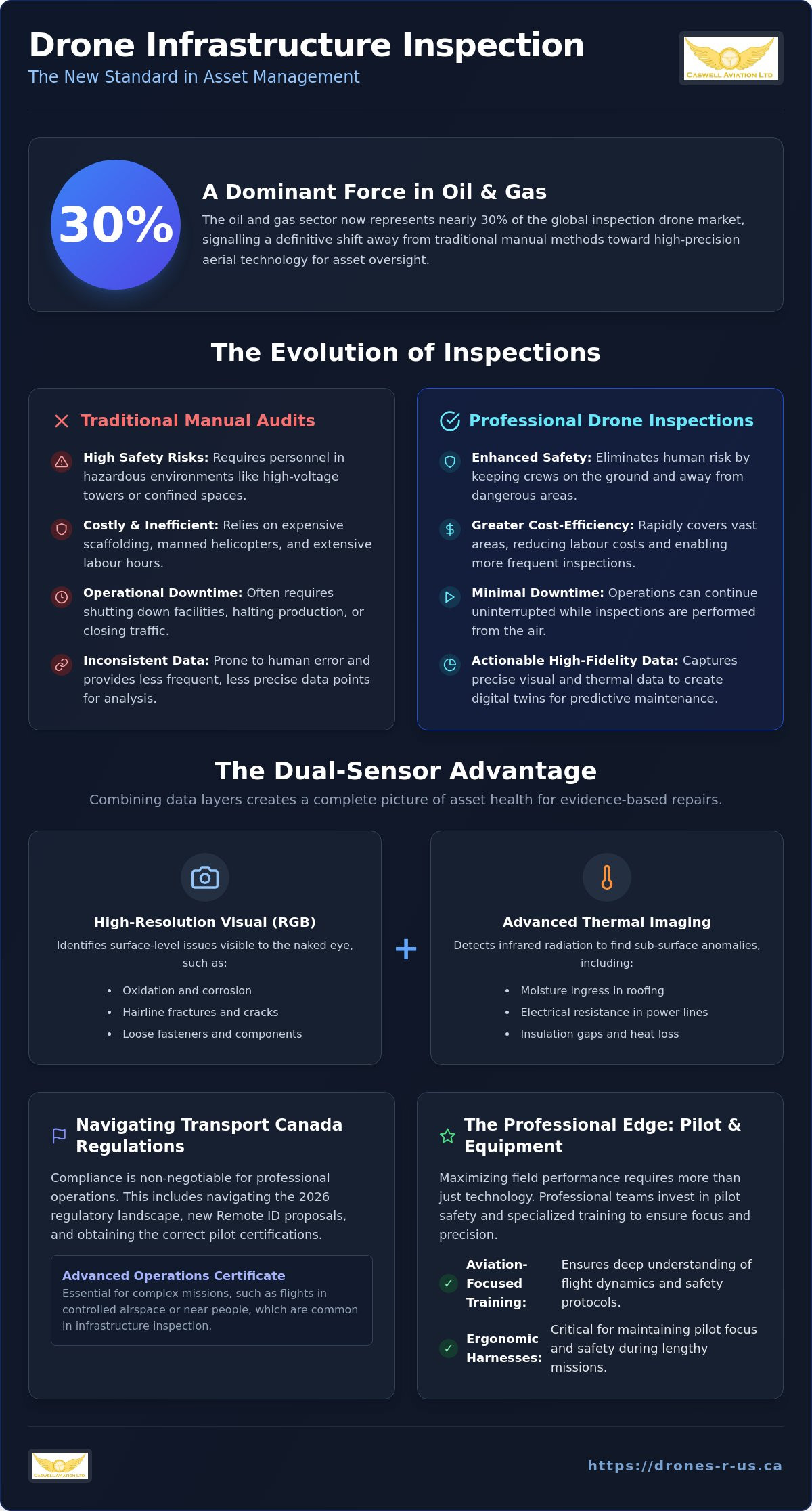
The oil and gas sector now accounts for nearly 30% of the global inspection drone market, a clear indicator that traditional manual methods are no longer the industry standard. If you manage assets in Alberta, you already know that sending crews up scaffolding or into confined spaces is a costly, high-risk endeavour that often leads to inconsistent data. Utilizing professional drone infrastructure inspection Calgary services allows you to replace these dangerous tasks with high-precision aerial technology that delivers immediate, actionable results.
This guide explains how to integrate advanced thermal imaging and visual data sets to enhance asset safety while maintaining strict operational efficiency. You'll learn how to navigate the 2026 Transport Canada landscape, including the new Remote ID proposals and the nuances between Advanced and Basic certifications. We'll outline the specific technical requirements and pilot training necessary to ensure your infrastructure remains secure, compliant, and functional throughout the year.
Key Takeaways
- Learn how professional drone infrastructure inspection Calgary services reduce operational downtime and eliminate the safety risks associated with manual structural audits.
- Discover how thermal imaging identifies sub-surface defects and heat anomalies in critical assets such as power lines and industrial roofing.
- Understand the regulatory requirements for Advanced and Level 1 Complex flight operations to ensure your team remains compliant with Transport Canada standards.
- Identify the importance of specialized pilot equipment, such as ergonomic harnesses, to maintain focus and safety during lengthy inspection missions.
- Evaluate the benefits of aviation-focused training and professional aerial imagery to secure high-resolution data for long-term asset management.
The Evolution of Infrastructure Inspection via Remotely Piloted Aircraft Systems (RPAS)
By 2026, the transition to Remotely Piloted Aircraft Systems (RPAS) for structural oversight has moved from an experimental phase to a professional standard for asset managers across Canada. Traditional manual inspections are increasingly viewed as obsolete because they rely on physical climbing, scaffolding, or expensive manned helicopter flights. These methods are inherently slow and introduce unnecessary human risk. In contrast, a drone infrastructure inspection Calgary team can deploy in minutes to capture high-fidelity data. This speed allows for the rapid creation of digital twins, which are precise 3D models used for predictive maintenance and structural analysis.
Safety remains the primary driver for this technological shift. Removing personnel from hazardous environments, such as high-voltage transmission towers or confined pipeline corridors, significantly reduces liability and operational risk. The cost-efficiency is equally compelling. Inspection drones can cover miles of pipeline or complex bridge spans in a fraction of the time required for ground crews. This efficiency translates to lower labour costs and more frequent data collection cycles, ensuring that structural integrity is monitored with a level of consistency that was previously impossible to achieve.
Visual vs. Thermal Data Collection
Professional drone infrastructure inspection Calgary operations utilize a dual-sensor approach to capture a complete picture of asset health. High-resolution RGB cameras provide the visual clarity needed to identify surface-level issues like oxidation, hairline fractures, or loose fasteners. However, visual data alone is often insufficient. Thermal sensors detect infrared radiation to find anomalies invisible to the human eye. These include moisture ingress in roofing, electrical resistance in power grids, or insulation gaps in industrial kilns. Combining these data layers creates a comprehensive report that allows engineers to prioritize repairs based on technical evidence rather than visual guesswork.
Impact on Operational Downtime
One of the most significant advantages of RPAS technology is the reduction of facility closures. Traditional inspections often require shutting down traffic on bridges or halting production in manufacturing plants to accommodate inspectors. Drones operate independently of these constraints. They provide rapid deployment for emergency assessments after extreme weather events, ensuring that infrastructure is safe for use without lengthy delays. This preventative monitoring cycle offers a high long-term ROI by identifying minor faults before they escalate into catastrophic failures. Asset managers can now realize significant savings by shifting from reactive repairs to a structured, drone-led maintenance schedule.
Leveraging Thermal Drone Inspection for Critical Asset Management
Thermal drone inspection serves as a sophisticated method for detecting heat signatures that indicate underlying structural or mechanical defects. This technology captures infrared radiation to visualize temperature variations across an asset's surface. Thermal inspection is a non-destructive testing (NDT) method that evaluates the integrity of an asset without causing physical damage. In the context of drone infrastructure inspection Calgary, these sensors are indispensable for auditing solar farms, monitoring high-voltage power lines, and assessing the thermal envelope of commercial buildings.
While drones focus on the exterior thermal envelope, internal climate systems require specialized care; to keep your residential environment efficient, you can discover Caribbean Heating & Cooling for expert HVAC installation and maintenance.
Identifying insulation gaps and moisture intrusion early prevents costly structural failures. For example, solar farm audits use thermal data to find hot spots or dead cells that reduce energy output. Similarly, power line monitoring detects resistance-related heating in connectors before they lead to grid outages. If you require high-resolution data for these applications, professional drone aerial photography and video services can provide the technical clarity needed for informed decision-making.
Detecting Structural Heat Signatures
Structural heat signatures provide a window into the internal condition of an asset. Mechanical components like bearings or motors often generate excess heat due to friction well before a total breakdown occurs. In the building sector, thermal cameras identify water ingress in flat roofing systems through the principle of evaporative cooling. Trapped moisture retains heat differently than dry insulation; this contrast becomes highly visible during the thermal crossover periods at dawn or dusk. Pilots must understand emissivity, which is the efficiency with which a surface emits thermal energy. Reflective surfaces like polished metal can produce false readings. This requires an experienced operator to adjust camera angles and settings for accurate data collection.
The Role of Radiometric Data
Professional thermal inspections go beyond simple visual maps. While a standard thermal image shows relative temperature differences, radiometric data provides a specific temperature value for every pixel. This per-pixel metadata is essential for engineering reports that require precise measurements to meet safety standards. Utilizing radiometric data sets allows analysts to quantify the severity of a defect during post-processing. Specialized software is necessary to interpret these sets and generate comprehensive health reports. Maintaining this level of technical precision is a requirement for missions that fall under the latest Transport Canada drone regulations, ensuring that all data captured is both legally compliant and technically sound.
Navigating Transport Canada Regulations for Advanced Infrastructure Missions
Operating a drone for structural audits in Alberta requires strict adherence to Part IX of the Canadian Aviation Regulations. Because most industrial assets are located within controlled airspace or near populated areas, the Advanced Pilot Certificate is a mandatory requirement. For a professional drone infrastructure inspection Calgary, pilots must demonstrate a high level of technical competency to ensure the safety of both the public and the critical utilities they are monitoring. Compliance isn't just a legal hurdle; it's a foundational element of professional risk management that protects your organization from significant liability.
High-risk missions often involve flying within 30 metres of bystanders or directly over people. These scenarios require a Level 1 Complex declaration from the drone manufacturer and specific pilot certifications. Understanding these tiers is essential for asset managers who need to verify that their service providers are legally authorized to perform the work. If you're building an internal team, staying updated on Transport Canada drone certification requirements is the first step toward operational readiness.
Achieving Advanced and Complex Certification
The path to becoming a professional inspector starts with the Advanced written exam. This test covers topics ranging from meteorology to complex flight theory. Once the exam is passed, candidates must complete an in-person Flight Review. Caswell Aviation Ltd provides these professional reviews to validate a pilot's ability to handle emergency procedures and site surveys. Remember that certification is not a one-time event. Pilots must complete a recurrent training activity every 24 months to maintain their recency. This ensures that every operator remains proficient in the latest safety protocols and regulatory changes.
Operating in Controlled Airspace
Infrastructure near Calgary International Airport or within the city centre requires direct coordination with NAV CANADA. Pilots must secure a flight authorization before takeoff, a process that has become more streamlined with the use of the NAV Drone and RPA Wilco applications. These tools allow for precise mission planning and real-time communication with air traffic control. Safety protocols during drone infrastructure inspection Calgary must also account for electromagnetic interference near high-voltage lines. Establishing clear "no-fly" zones and maintaining a visual line of sight are non-negotiable standards for missions involving critical utilities or heavy machinery.
Maximizing Field Performance: Ergonomics and Pilot Safety
Professional drone infrastructure inspection Calgary missions often require pilots to remain on-site for 8 to 10 hour shifts. Carrying a high-resolution smart controller for these extended periods creates significant physical strain on the neck and upper back. The physical toll includes muscle tension and reduced circulation in the hands, which can impair the fine motor skills required for delicate flight manoeuvres. Standard neck straps are insufficient for this workload. They concentrate the entire weight of the device on a single point of the cervical spine. This imbalance leads to chronic fatigue, which is a leading contributor to operational errors during high-stakes structural audits.
The Benefits of Fitek Gear Drone Harnesses
Utilizing a professional drone harness for smart controller ensures even weight distribution across the shoulders and torso. This ergonomic support is critical for pilots using heavy DJI Enterprise or Autel smart controllers that often weigh over 1 kilogram. By stabilizing the remote interface, the harness allows for greater stick precision. This precision is vital when navigating a drone within close proximity to bridge trusses or high-voltage transmission lines. Fitek Gear is designed to withstand the rugged conditions of the Canadian field, including high-wind environments and freezing temperatures that can affect material flexibility.
Pilot Endurance and Mission Success
Comfort correlates directly to reduced pilot error and improved mission success rates. During multi-battery missions, managing the cumulative weight of hardware is a safety requirement. A fatigued pilot is less likely to notice subtle technical anomalies or environmental hazards. In professional aviation, ergonomic equipment is considered a standard component of pilot personal protective equipment (PPE). It sits alongside high-visibility vests and safety boots as a necessary tool for risk mitigation. For any drone infrastructure inspection Calgary project, the focus must remain on the data and the safety of the surrounding environment. Professional teams prioritize pilot health to ensure that the final data output is not compromised by human exhaustion.
If you are looking to equip your team with professional-grade support, you can browse our selection of Fitek Gear harnesses designed specifically for long-form missions.
Selecting Professional Aerial Imagery and Training Partners
Choosing a partner for drone infrastructure inspection Calgary requires an evaluation of their aviation background rather than just their camera specifications. Many retail-led instruction centres focus on basic flight mechanics but lack the technical depth required for industrial safety standards. An aviation-backed training provider understands the regulatory environment and the specific risks associated with flying near critical infrastructure. This expertise ensures that your data is captured legally and safely, providing a reliable foundation for your structural health reports. Selecting a partner with a culture of discipline is the most critical decision for any asset manager.
Professional aerial imagery services should offer more than just raw footage. They must provide turnkey solutions that include processed data sets ready for engineering analysis. This includes high-resolution visual imagery and radiometric thermal data that can be integrated into existing asset management software. By utilizing an expert mentor for your training and imagery needs, you ensure that your drone operations contribute directly to operational efficiency rather than becoming a technical burden.
Caswell Aviation Ltd: Your Master Practitioner in RPAS
Caswell Aviation Ltd combines technical flight reviews with extensive real-world inspection experience. We offer customized training programmes specifically designed for corporate engineering teams who need to integrate RPAS into their existing workflows. Our drone aerial photography and video services deliver high-quality content tailored to specific structural requirements. This master practitioner approach ensures that every mission is executed with the discipline of a veteran aviator, resulting in superior data quality and strict regulatory compliance. We position ourselves as a stable partner for organizations that value precision over flashy marketing.
Building Your Internal Drone Programme
Many organizations eventually transition from outsourcing to building an internal pilot team to maximize long-term cost-efficiency. This transition requires a structured approach to equipment procurement and pilot certification. A successful internal programme relies on the following pillars:
- Obtaining Advanced Pilot Certificates and Level 1 Complex flight reviews for all operators.
- Standardizing on industrial-grade hardware equipped with radiometric thermal sensors.
- Equipping pilots with ergonomic tools, such as Fitek Gear harnesses, to maintain focus during long shifts.
- Establishing a recurrent training schedule to meet Transport Canada recency requirements every 24 months.
Ongoing support and advanced training are essential for managing complex missions as your programme scales. Furthermore, if you require assistance with the documentation needed for funding or procurement, Dynamic Contracts Consultants LLC provides specialized proposal and grant writing services to support your growth. If you are ready to enhance your asset management strategy, booking a professional consultation is the logical next step for corporate drone integration. Our team at Caswell Aviation Ltd is prepared to guide you through the technical and regulatory prerequisites to ensure your drone infrastructure inspection Calgary operations are safe, efficient, and fully certified.
Securing the Future of Structural Asset Management
The integration of RPAS technology into structural maintenance is no longer a luxury but a requirement for modern asset management. Prioritizing high-resolution thermal data and ergonomic pilot support allows your organization to significantly reduce operational downtime while enhancing safety. Navigating the technical and legal complexities of drone infrastructure inspection Calgary requires a partner who understands the nuances of Transport Canada regulations and the demands of industrial environments. Precision in data collection is the only way to ensure long-term structural integrity.
Caswell Aviation Ltd serves as your expert mentor in this transition. With a Transport Canada Advanced Flight Reviewer on staff and deep expertise in Level 1 Complex operations, we provide the authoritative guidance your team needs to remain compliant. As a specialized Fitek Gear distributor, we also ensure your pilots have the ergonomic support necessary for mission success. Whether you require turnkey aerial imagery or comprehensive corporate training, we're here to support your specific operational goals.
Contact Caswell Aviation Ltd for Professional Training and Aerial Services to begin building a safer, more efficient inspection programme today. We look forward to helping you master the next generation of aerial technology.
Frequently Asked Questions
What is the difference between visual and thermal drone inspections?
Visual drone inspections use high-resolution RGB cameras to identify surface-level defects like structural cracks, loose fasteners, or corrosion. Thermal inspections capture infrared radiation to detect temperature anomalies that indicate moisture ingress, insulation failures, or electrical resistance. Combining both sensors provides a more complete assessment of an asset's health than either method could achieve alone.
Do I need an Advanced Transport Canada certificate for infrastructure inspection?
Yes, an Advanced Pilot Certificate is required for any drone infrastructure inspection Calgary mission conducted in controlled airspace or within 30 metres of bystanders. Most structural assets in urban or industrial corridors fall under these specific categories. Pilots must pass the Advanced written exam and complete an in-person Flight Review to operate legally in these complex environments.
How much does a professional drone infrastructure inspection cost in Canada?
The cost of a professional inspection depends on the complexity of the asset, the geographic location, and the specific sensors required for the mission. Factors such as flight duration, data processing requirements, and the level of operational risk also influence the final investment. It's best to request a customized quote to ensure all technical and regulatory requirements are covered for your specific site.
Can drones inspect infrastructure in controlled airspace?
Drones can operate in controlled airspace provided the pilot holds an Advanced certificate and obtains a flight authorization from NAV CANADA. Professional operators use tools like the NAV Drone app to coordinate directly with air traffic control. This coordination ensures that infrastructure inspections near airports or city centres are conducted without compromising the safety of manned aviation.
What are the benefits of using a Fitek Gear harness for inspections?
A Fitek Gear harness improves mission safety by distributing the weight of a smart controller across the pilot's shoulders and torso. This prevents neck strain and reduces physical fatigue during long-form inspections that can last several hours. By stabilizing the remote interface, the harness also allows for more precise stick movements, which is critical when flying in close proximity to sensitive structural components.
How long does it take to get a Level 1 Complex drone certification?
Obtaining a Level 1 Complex drone certification involves manufacturer declarations and specific pilot training. While an Advanced certificate can be earned relatively quickly, the turnaround times for Transport Canada to process complex applications depend on current departmental volumes. It's recommended to start the certification process several weeks before a planned mission to ensure all regulatory paperwork is finalized.
What industries benefit most from thermal drone imaging?
The oil and gas industry benefits significantly from thermal imaging for pipeline leak detection and facility monitoring. Other key sectors include commercial roofing for moisture audits and utility providers for power line inspections. Utilizing drone infrastructure inspection Calgary services in these industries allows for the early identification of heat-related defects that remain invisible to the naked eye.
How do drones handle weather conditions during Canadian inspections?
Professional drones used for Canadian inspections are designed to handle moderate wind and cold temperatures, but they have specific operational limits. Pilots must monitor battery temperatures and wind speeds to ensure safe flight. While some aircraft have high IP ratings for moisture resistance, most missions are scheduled during clear weather to ensure the highest possible quality of visual and thermal data.
Leave a comment