

Professional Aerial Imagery Services in Canada: A 2026 Buyer’s Guide
Hiring a hobbyist with a drone for a commercial site isn't just a risk to your project's data quality; it's a direct liability under Transport Canada’s 2026 regulatory framework. You likely realize that precision data is now the standard for industrial and creative projects, but finding reliable aerial imagery services in Canada remains difficult when uncertified operators saturate the market. It's frustrating to receive raw files that don't align with your existing CAD or GIS workflows, or worse, to discover your provider lacks the necessary certification for complex environments.
This guide provides a clear path to evaluating providers based on technical merit and safety standards. You'll learn exactly how to verify pilot credentials, understand the value of high-resolution orthomosaics, and ensure your data collection is both cost-effective and fully compliant with the latest aviation laws. We will examine the essential criteria for choosing a partner who can translate raw flight data into actionable professional insights.
Key Takeaways
- Understand the practical differences between satellite imagery, manned aircraft, and RPAS to choose the most precise data collection method for your specific project needs.
- Learn to evaluate technical benchmarks like Ground Sampling Distance (GSD) to guarantee that your high-resolution data meets professional industry standards for clarity.
- Identify the essential criteria for selecting professional aerial imagery services in Canada, focusing on Transport Canada compliance and advanced operational certifications.
- Realize the cost-saving benefits of drone-based data collection for site inspections and infrastructure monitoring compared to traditional manned aviation methods.
- Gain a clear understanding of the 2026 regulatory environment to ensure your flight operations are safe, legal, and managed by qualified practitioners.
Navigating the Landscape of Aerial Imagery Services in Canada
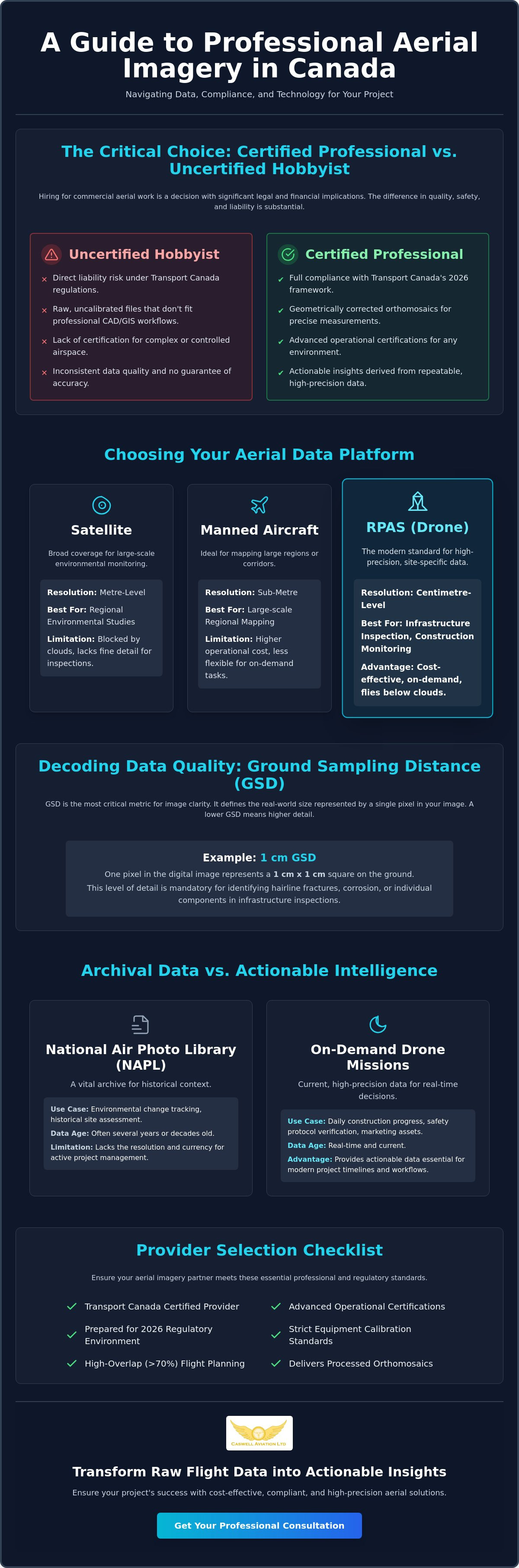
The term aerial imagery services Canada describes a range of professional data collection methods used to capture high-resolution visual information from an elevated perspective. While the history of aerial photography began with fixed-wing aircraft and specialized film cameras, the modern industry is defined by digital precision and rapid deployment. Commercial operators now categorize these services based on the platform used: satellites, manned aircraft, or Remotely Piloted Aircraft Systems (RPAS).
In 2026, drone technology has become the standard for projects requiring centimetre-level accuracy. Manned aircraft remain useful for large-scale regional mapping, but they cannot match the cost-efficiency or resolution of a drone for site-specific work. We have seen a significant shift from using imagery as a historical reference to using it as a tool for active project management. Instead of reviewing a site once a year, project managers now use frequent flights to monitor daily construction progress and verify safety protocols.
Satellite vs. Drone Imagery: Which Do You Need?
Choosing the right platform depends on your required level of detail. Satellites provide metre-level resolution, which works well for broad environmental studies but fails to capture the fine details needed for infrastructure inspections. Professional drones deliver centimetre-level clarity, allowing you to see individual bolts on a bridge or cracks in a paved surface. Drones also solve the problem of atmospheric interference. While clouds often block satellite sensors, a drone flies below the cloud base to ensure data is collected on schedule. For smaller geographic areas, on-demand drone missions offer better value than high-resolution satellite tasking.
The Role of the National Air Photo Library
The National Air Photo Library (NAPL) is a vital resource for understanding the past. It contains over 6 million images dating back to the 1920s, providing a comprehensive record of Canada's landmass. These archives are indispensable for environmental change tracking and historical site assessments during the due diligence phase of a project.
Government archives are not designed for active project needs. The data is often several years old and lacks the resolution required for modern engineering or construction modelling. When your workflow demands real-time precision or high-quality marketing assets, a custom mission is necessary. Specialized Drone Aerial Photography and Video provides the current, actionable data that historical archives cannot supply. This distinction is critical for maintaining project timelines and ensuring all stakeholders have access to accurate, up-to-date information.
Technical Standards for High-Resolution Aerial Data
Professional data collection is defined by its precision and repeatability. When you contract aerial imagery services Canada, the value isn't found in the raw photographs themselves, but in the mathematical accuracy of the final dataset. Achieving this requires a rigorous adherence to technical benchmarks that separate industrial-grade results from casual photography. Professional pilots organize flight paths using high-overlap grid patterns, often exceeding 70% front-lap and side-lap, to ensure every feature is captured from multiple perspectives. This redundancy is the foundation of accurate photogrammetry and 3D modelling.
The distinction between raw imagery and processed deliverables is significant. Raw files are individual snapshots with inherent perspective distortion. Deliverables like orthomosaics are geometrically corrected so the scale is uniform across the entire image. This allows project managers to treat the map as a reliable document for measuring distances, areas, and volumes with confidence. Reliability in these outputs is only possible when working with a Transport Canada Certified Provider who maintains strict equipment calibration and flight standards.
Understanding GSD and Spatial Accuracy
Ground Sampling Distance, or GSD, is the most critical metric for image clarity. It represents the distance between the centres of two consecutive pixels measured on the ground. For example, a GSD of 1cm per pixel means that one pixel in your digital image represents exactly one square centimetre of physical space. For high-stakes infrastructure inspections, a lower GSD is mandatory to identify hairline fractures or corrosion. To achieve this, professional systems utilize Real-Time Kinematic (RTK) technology. RTK provides centimetre-level spatial precision by correcting GPS signals in real time, ensuring that every data point is anchored to its exact geographical coordinate.
Common Deliverables: From Photos to Photogrammetry
A professional mission produces a variety of specialized outputs tailored to specific industry needs. 2D orthomosaic maps provide a "top-down" view that serves as a current site plan for construction or land development. For engineering applications, 3D point clouds and Digital Surface Models (DSM) offer a detailed representation of terrain and structures, which is essential for drainage analysis or earthwork volume calculations. Beyond technical data, creative deliverables like stabilized 4K video remain the standard for corporate storytelling and stakeholder engagement. If your internal team is looking to master these technical requirements, completing Advanced & Level 1 Complex Flight Reviews is a necessary step to ensure your operations meet these national standards.
Core Commercial Applications for Aerial Imagery
Professional drone operations have moved beyond simple photography. Today, aerial imagery services Canada serve as a critical bridge between physical sites and digital management systems. While the technical standards discussed earlier provide the foundation, the practical application varies significantly between creative and technical disciplines. Creative media focuses on visual impact and brand engagement, whereas technical geospatial imagery prioritizes measurable accuracy and data integration. Understanding this distinction is vital for businesses looking to maximize their return on investment.
Adopting drone-based data collection often results in a direct reduction in operational costs. Traditional methods, such as using manned helicopters or manual ground surveys, are time-consuming and often require site shutdowns. Drones allow for continuous monitoring without interrupting daily workflows. This efficiency translates to faster project completion and more accurate budgeting for large-scale industrial operations. When companies realize these efficiencies, they often move from occasional use to integrated, daily data collection.
Construction and Infrastructure Monitoring
The construction industry is currently the largest adopter of professional drone technology. Drones provide a safer and faster method for inspecting critical infrastructure like bridges, communications towers, and industrial roofs. Instead of deploying teams on ropes or in bucket trucks, a pilot can capture high-resolution imagery from a safe distance. For site managers, drone data is particularly useful for stockpile management. By using photogrammetry, operators can calculate the volume of materials on-site with high precision in a fraction of the time required for traditional surveying.
Construction firms utilize weekly orthomosaics to overlay current site conditions against CAD designs, allowing project managers to identify deviations immediately and reduce project delays. This proactive approach ensures that errors are caught before they become expensive structural issues. Many firms now choose to integrate professional Drone Aerial Photography and Video into their weekly reporting to keep stakeholders informed of progress through clear, visual evidence.
Real Estate and Corporate Media
In the competitive real estate market, aerial perspectives are no longer optional for high-end listings. Aerial imagery provides a sense of scale and context that ground photography cannot match. It allows potential buyers to see the entire property boundary, the layout of the neighbourhood, and the proximity to local features. Integrating these views into corporate brand stories also helps companies project a modern, sophisticated image. For professionals looking to refine their skills in this area, Mastering Advanced Aerial Photography Techniques for Real Estate in 2026 offers specific guidance on capturing high-impact visuals.
As these applications become more common, many organizations are developing internal drone programs. This shift requires a commitment to professional education. Providing Online Drone Courses and InPerson Training ensures that internal teams operate with the same discipline and regulatory knowledge as veteran practitioners. This cultural shift toward safety and precision is what ultimately defines a successful aerial program.
Compliance and Safety: Selecting a Transport Canada Certified Provider
Operating a commercial drone in Canada is a regulated aviation activity, not a casual photography session. For any drone weighing between 250 grams and 25 kilograms, federal law requires a Pilot Certificate. When you evaluate aerial imagery services Canada, compliance should be your first point of verification. Hiring an uncertified pilot exposes your business to significant legal and financial liability. If an incident occurs and the operator is found to be flying without the proper credentials or in violation of airspace rules, your corporate insurance may be voided, leaving your organization responsible for damages.
Verification of a provider is a straightforward process. You should request to see the operator's Pilot Certificate and proof of drone registration, which carries a $10 fee as of April 1, 2025. A professional practitioner will also provide a record of recurrent training. While certificates do not expire, pilots must complete a recurrent training activity every 24 months to remain compliant. Checking these documents ensures you are partnering with someone who respects the discipline of the Canadian aviation system.
The Importance of Advanced Certification
Transport Canada distinguishes between Basic and Advanced operations. Basic certification is limited to uncontrolled airspace and requires pilots to stay at least 30 metres away from bystanders. However, most commercial projects in urban centres or near industrial sites require Advanced certification. This allows for flight in controlled airspace and closer proximity to people. As of November 4, 2025, new regulations for lower-risk beyond-visual-line-of-sight (BVLOS) operations are also in effect, requiring pilots to be at least 18 years old and have completed 20 hours of ground school. For a deeper dive into these requirements, read The Complete Guide to Transport Canada Drone Certification in 2026.
Safety Protocols and Risk Management
A "Master Practitioner" approach to flight involves more than just stick skills. It requires a methodical commitment to safety protocols. Professional providers use standardized pre-flight checklists and conduct thorough site surveys before the aircraft ever leaves the ground. This process includes monitoring weather conditions and coordinating with NAV CANADA for airspace authorization when necessary. Furthermore, specialized liability insurance is a non-negotiable requirement for professional missions. Standard general liability policies often exclude aviation, so ensure your provider carries a dedicated RPAS (Remotely Piloted Aircraft System) policy.
To ensure your project is handled with this level of technical and legal rigor, consider booking your mission with a provider that prioritizes Advanced & Level 1 Complex Flight Reviews to maintain the highest operational standards.
Professional Aerial Solutions by Caswell Aviation Ltd
Caswell Aviation Ltd has established itself as a national leader in the sector by blending decades of aviation experience with modern RPAS technology. We take a "Master Practitioner" approach to every mission, ensuring that technical skill is always balanced with rigorous regulatory expertise. When businesses require aerial imagery services Canada, they need more than a pilot; they need a partner who understands the complex intersection of technical data and federal law. Our team doesn't just operate equipment; we manage the entire flight environment to ensure every data point is accurate and every mission is compliant.
There is a unique synergy between our educational programs and our high-end imagery services. Because we are responsible for training the next generation of pilots, we maintain a standard of excellence that exceeds basic industry requirements. This dual role as both an educator and a service provider means our methodology is constantly refined by the latest Transport Canada standards and technical advancements. We apply the same discipline to our Drone Aerial Photography and Video missions that we teach in our advanced flight reviews, providing a level of reliability that only a veteran mentor can offer.
Customized Imagery and Videography Services
Every project begins with a comprehensive brief to align our flight operations with your specific desired outcomes. We don't believe in a one-size-fits-all approach. Whether you need high-resolution orthomosaics for a 500-acre construction site or cinematic 4K video for a corporate brand story, we tailor our sensor selection and flight paths accordingly. Our experience allows us to operate effectively in complex environments across Canada, from congested urban centres to remote industrial facilities. For organizations ready to commission a mission, you can visit Caswell Aviation Ltd to start the consultation process.
The Professional Edge: Training and Equipment
Our role as a provider of Advanced & Level 1 Complex Flight Reviews gives us a distinct professional edge. We understand the nuances of the Canadian aviation landscape because we help define the standards for other pilots. This deep knowledge of the system ensures that your project never faces delays due to regulatory oversights. To learn more about these standards, read What is a Drone Flight Review in Canada? A Professional Guide for 2026.
Consistency in data collection also depends on pilot focus and ergonomic support. During long imagery flights, even minor physical fatigue can impact the precision of the flight path. We utilize professional-grade gear, such as Fitek Gear Drone Harnesses for Smart Controllers, to ensure our pilots remain comfortable and focused on the telemetry throughout the mission. This commitment to professional equipment and ergonomic standards is a key part of our strategy to deliver the highest-quality aerial imagery services Canada has to offer. By prioritizing both human factors and technical precision, we provide our clients with a stable, reliable, and deeply knowledgeable partnership.
Advancing Your Project with Professional Precision
The transition to high-resolution data collection represents a fundamental shift for Canadian industrial and creative sectors. You now have the capability to move beyond static historical archives and embrace real-time, centimetre-level precision for active project management. Selecting the right partner for aerial imagery services Canada requires a strict focus on technical accuracy and absolute regulatory compliance. By prioritizing providers who understand both the physics of flight and the requirements of the law, you protect your organization from liability while gaining actionable insights.
Caswell Aviation Ltd offers a unique combination of field experience and educational authority. As Transport Canada Advanced Certified Pilots and professional flight reviewers, we bring a culture of discipline to every mission. Our expertise as specialized retailers of ergonomic Fitek Gear further ensures that our pilots maintain the focus necessary for high-stakes data collection. Book Professional Aerial Imagery Services with Caswell Aviation Ltd today to ensure your next mission is executed with master-level precision. We look forward to helping you realize the full potential of your aerial data strategy.
Frequently Asked Questions
Is a special licence required for commercial aerial imagery in Canada?
Yes, a Pilot Certificate is mandatory for all commercial drone operations in Canada involving aircraft weighing between 250 grams and 25 kilograms. Operators must hold either a Basic or Advanced certificate depending on the specific airspace and the proximity of the flight to bystanders. Professional providers also ensure their drones are registered with Transport Canada and maintain a record of recurrent training every 24 months to remain compliant with federal aviation regulations.
How much do professional aerial imagery services typically cost?
Rates for aerial imagery services Canada vary based on the mission complexity, the required resolution, and the type of processed deliverables requested. While government archives like Natural Resources Canada provide historical digital photos at fixed rates per image, commercial providers typically structure fees by the hour or by the project. Factors such as the need for specialized sensors, RTK precision, or complex 3D modelling will influence the final cost of a professional mission.
Can drones fly in controlled airspace for photography missions?
Drones can operate in controlled airspace provided the pilot holds an Advanced Pilot Certificate and receives authorization from NAV CANADA. This process involves a formal request through the NAV Drone platform and adherence to specific altitude and lateral limits. Professional operators handle all airspace coordination and communication with air traffic control to ensure the mission is conducted safely without interfering with manned aviation, a commitment to safety shared by professional flight organizations such as UK Skydiving.
What is the difference between an orthomosaic and a regular aerial photo?
An orthomosaic is a map-accurate image composed of many overlapping photos that have been geometrically corrected to remove perspective distortion. Unlike a regular aerial photo, which has a varying scale depending on the terrain and camera angle, an orthomosaic has a uniform scale across the entire image. This allows project managers to use the file for precise measurements of distance, area, and volume directly within CAD or GIS software.
How long does it take to receive the final aerial imagery deliverables?
Final deliverables are typically provided within 24 to 72 hours after the flight is completed. While raw 4K video or high-resolution photographs can be transferred almost immediately, processed data like 3D point clouds and orthomosaic maps require significant processing time. This ensures that the photogrammetry software correctly aligns thousands of data points to meet professional accuracy standards.
What happens if the weather is poor on the day of the scheduled flight?
Missions are rescheduled if weather conditions, such as high winds, rain, or low cloud cover, exceed the safety parameters of the aircraft. Professional pilots monitor aviation weather forecasts continuously and will make a final "go or no-go" decision based on real-time site conditions. Rescheduling ensures the safety of the equipment and guarantees that the collected imagery is clear and free from environmental interference.
Do I need to be on-site during the aerial imagery mission?
You don't need to be physically present on-site as long as the pilot has been provided with a clear mission brief and any necessary site access permissions. Most professional providers conduct a remote site survey and coordinate with site supervisors before arrival. This allows the flight team to focus on the technical execution of the flight and the safety of the surrounding environment.
What is the maximum resolution a drone can provide for mapping?
Modern drone systems can provide a Ground Sampling Distance (GSD) as fine as 1 centimetre per pixel, depending on the flight altitude and sensor quality. This centimetre-level resolution is significantly more detailed than the 20-centimetre or 30-centimetre resolution typically found in regional government imagery programs. This high level of detail is essential for infrastructure inspections where identifying small defects is a primary project requirement.
Leave a comment