

How to Price Drone Photography and Mapping Services in Canada (2026)
Most drone pilots in Canada aren't actually charging for their flight time; they're accidentally paying their clients for the privilege of working. It's a common frustration to watch unlicensed hobbyists undercut your quotes while you struggle to account for the true cost of Transport Canada compliance and intensive post-processing. You realize that capturing the data is only a small fraction of the job, yet many professionals still find it difficult to determine how to price drone photography services Canada in a way that ensures long-term sustainability.
We agree that your expertise, certification, and high-end equipment deserve a return that reflects your professional status. This article promises to help you master the specific formulas and regulatory factors required to set profitable, competitive rates for aerial services across the country. We will provide a clear framework for project-based pricing, explain how to justify higher rates through safety compliance, and share a professional method for quoting complex mapping jobs that accounts for every hour spent at the computer. By the end of this guide, you'll have the tools to organize your business around precision and profitability.
Key Takeaways
- Identify your fixed operational costs, including Transport Canada registration and equipment depreciation, to establish a baseline for long-term profitability.
- Compare the benefits of hourly rates for short inspections against day rates for large-scale commercial deployments to determine the most efficient pricing model.
- Learn how to price drone photography services Canada by differentiating between creative imagery and the technical complexity of survey-grade mapping data.
- Leverage your Advanced Operations certification and safety compliance as premium levers to justify higher rates for missions in controlled airspace.
- Develop professional quotations that itemize technical and regulatory value to avoid under-quoting and secure high-value contracts.
Establishing Your Operational Cost Baseline
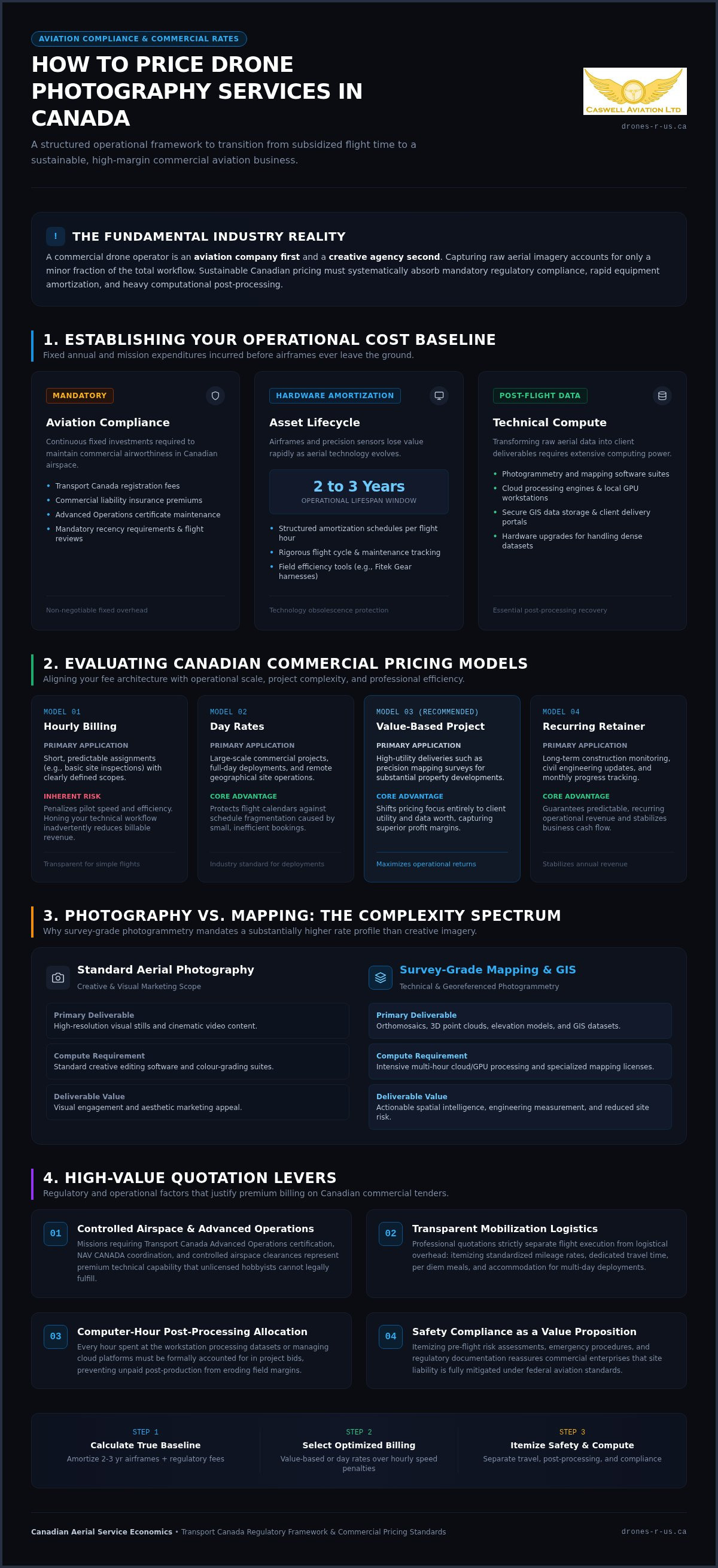
Setting a profitable rate begins with a thorough understanding of your internal expenses. Many operators overlook the reality that their business is an aviation company first and a creative agency second. To determine how to price drone photography services Canada, you must first realize that your baseline is built on identifying fixed annual costs that exist regardless of how many hours you spend in the air. These include mandatory Transport Canada registration fees, commercial liability insurance premiums, and the costs associated with maintaining your Advanced Operations certificate. Professional training is a recurring investment, as recency requirements and flight reviews ensure you remain compliant with current Canadian aviation regulations.
Equipment and Asset Depreciation
High-performance airframes and specialized sensors represent significant capital investments that lose value with every flight hour. Professional pilots use a structured amortization schedule to spread the cost of these assets over their expected operational life, which is typically two to three years for rapidly evolving technology. You must also account for field accessories that directly impact your output and mission safety. For instance, using ergonomic Fitek Gear harnesses allows for longer, more comfortable flight durations, which increases your daily efficiency on complex job sites. Equipment lifecycle management involves a systematic approach to tracking flight cycles and maintenance intervals to ensure every asset remains airworthy and financially viable.
Software and Post-Processing Overhead
Data collection is only half the battle. The technical complexity of drone photogrammetry and mapping requires significant computing power and specialized software suites. Whether you opt for cloud-based processing platforms or high-end local hardware, these subscription and maintenance fees must be recovered through your project quotes. Secure data storage and client delivery portals also add to your monthly overhead. When you calculate how to price drone photography services Canada, you'll need to allocate a portion of every invoice to cover these licensing fees and the hardware upgrades necessary to handle large-scale GIS datasets. Professional results depend on professional tools, and your pricing must reflect the cost of maintaining this technical edge.
Evaluating Competitive Pricing Models for the Canadian Market
Selecting the right billing structure is a critical step in maintaining professional stability. When you evaluate how to price drone photography services Canada, you'll find that your choice of model often dictates your long-term profitability. Hourly rates are generally the best fit for short, predictable assignments like basic site inspections where variables are limited. Conversely, day rates are the industry standard for large-scale commercial projects or remote deployments. This approach protects your schedule from being fragmented by small, inefficient bookings. You might also consider project-based pricing to align your fee with the specific value delivered, or retainer models to secure recurring revenue for monthly progress tracking.
When to Use Project-Based vs. Hourly Rates
Hourly billing offers transparency but can unintentionally penalize your efficiency. If you've invested in professional online drone courses to sharpen your technical workflow, you shouldn't be paid less simply because you can complete a mission faster than a novice. Value-based pricing shifts the focus to the client's outcome. A precision mapping survey for a large development carries significantly more risk and utility than a standard aerial photo. Charging based on the complexity and the data's worth ensures you maintain higher margins while serving a national Canadian client base that expects professional results.
Calculating Travel and Mobilization Fees
Professional quotations must account for the logistical costs of moving gear and personnel. Mobilization fees should standardize mileage rates and travel time for any mission outside your immediate operational area. For multi-day deployments, you'll need to factor in accommodation and per diem costs to cover meals and lodging. Transparent communication is vital here. Ensure your quote clearly separates these expenses from your professional service fee. Every mission requires meticulous pre-flight planning to comply with Transport Canada drone safety regulations, and this administrative time is a legitimate part of your mobilization overhead.
Photography vs. Mapping: Adjusting Rates for Technical Complexity
Distinguishing between creative visuals and technical data collection is a fundamental requirement for any professional determining how to price drone photography services Canada. Creative imagery focuses on composition, lighting, and aesthetics, while mapping demands survey-grade precision and absolute accuracy. This technical rigour justifies a significant price gap. For instance, agricultural and environmental projects often utilize a price-per-hectare model. This approach accounts for the vast areas covered and the standardized nature of the data required for year-over-year comparisons.
Mapping missions carry specific operational risks that standard photography does not. Automated flight grids require high battery discharge rates and constant sensor activity, which accelerates equipment wear and tear. You aren't just selling a photo; you're selling a functional dataset. This "Data Premium" covers the complex processing required to deliver orthomosaics, 3D models, and point clouds. When establishing these specialized rates, refer to professional guidance on setting service pricing and cost baselines to ensure your technical overhead and processing time are fully recovered.
Pricing Professional Drone Mapping Jobs
Ground Sampling Distance (GSD) is a primary driver of mapping costs. A requirement for higher resolution forces the drone to fly at a lower altitude, which increases the number of flight lines and total images captured. This directly impacts your field time and the subsequent hours spent in post-processing. Additionally, you must factor in the deployment of Ground Control Points (GCPs). Measuring these points with high-precision GPS units adds significant labour but ensures the spatial accuracy your clients expect. Specialized deliverables, such as volumetric analysis for construction or thermal mapping for utilities, should be treated as high-value additions to your base mapping rate.
Standardizing Aerial Photography Packages
Creative services are often more effective when presented as tiered packages. Real estate and marketing clients appreciate knowing exactly what they'll receive for their investment. However, you must manage scope creep by clearly defining the number of edited photos and the length of the final video in your contract. If you're looking for inspiration on how to structure these creative offerings, this corporate drone video guide offers a professional perspective on deliverables. By standardizing your photography packages, you simplify the sales process while protecting your time from repetitive revision requests.
Factoring in Aviation Compliance and Regulatory Overhead
Professional aviation requires more than just technical skill; it demands a commitment to a rigorous regulatory framework. When you evaluate how to price drone photography services Canada, you must account for the administrative and financial weight of maintaining compliance. This includes the time spent coordinating with NAV CANADA for flight authorizations and the costs of specialized insurance. While basic liability insurance is a standard requirement, hull insurance for expensive airframes adds another layer of protection that should be reflected in your rates. You're not just charging for the flight, but for the extensive preparation and legal standing that make the mission possible.
Maintaining your status as a professional pilot also involves recurring costs that must be recovered. Transport Canada requires pilots to maintain recency through various methods, including mandatory flight reviews every 24 months. These reviews ensure you remain current with evolving safety standards and operational procedures. Failing to bake these recurring educational and certification costs into your project fees will eventually erode your business's sustainability.
The Value of the Advanced Pilot Certificate
Holding an Advanced Operations certificate opens doors to high-value contracts in controlled airspace and urban environments. You can justify a premium rate for these missions because they require a level of training and risk management that basic operators cannot provide. It's your responsibility to educate clients on the legal necessity of hiring certified Transport Canada pilots for work near people or in restricted zones. Leveraging a Level 1 Complex status is particularly effective for winning industrial and infrastructure contracts, as these clients prioritize safety and regulatory adherence over the lowest possible bid.
Managing Risk and Safety Premiums
Complex missions in high-density areas or regions with significant electromagnetic interference require additional resources. You should apply a specific risk premium when a site's environment increases the likelihood of equipment fatigue or operational difficulty. This might include the cost of a dedicated Visual Observer (VO) to ensure clear communication and safety during the flight. Safety compliance is a non-negotiable part of a professional quote because it protects both the operator and the client from significant legal and financial liability. By itemizing these safety measures, you demonstrate that your pricing is rooted in discipline and professionalism.
If you need to update your credentials to access these high-value opportunities, consider booking one of our Advanced flight reviews to maintain your professional standing.
Developing Professional Quotations that Convert High-Value Contracts
A professional bid begins long before the drone leaves the case. Conducting a detailed needs assessment is the first step in protecting your margins and ensuring you don't under-quote a complex site. When you determine how to price drone photography services Canada, you must realize that a single price tag rarely captures the full scope of a commercial mission. Your final quotation should serve as a transparent roadmap of the project's value, itemizing costs across creative, technical, and regulatory categories. This structure helps the client understand they aren't just paying for a flight, but for a compliant aviation operation and precision data processing. By breaking down the bid, you demonstrate a level of discipline that unlicensed hobbyists cannot match.
The Anatomy of a Winning Drone Service Quote
A professional PDF proposal provides a physical anchor for your services and establishes your authority. It should include a clear "Terms and Conditions" section that specifically addresses the realities of Canadian flight operations. Weather-related rescheduling is a primary concern for any pilot. You must define what constitutes a "no-fly" day and how the costs of mobilization are handled if a mission is cancelled due to wind or precipitation. For extensive mapping projects, you should establish payment milestones that trigger at the completion of specific phases, such as the initial site survey and the final data delivery. This protects your cash flow and ensures the client remains engaged throughout the project lifecycle.
Communicating Value to the Client
Success in high-value contracting requires shifting the conversation from hardware to outcomes. Instead of discussing specific drone models, focus on how your actionable data and imagery solve the client's specific business problems. Use past performance or case studies to demonstrate the accuracy and reliability of your results. This evidence justifies your professional rates and positions you as a partner rather than just a vendor. Professionals who lead with expertise rather than the lowest price are more likely to secure multi-year service agreements. Occasionally, you may encounter clients with high-frequency needs. In these instances, you can build trust by recommending they invest in certified training for their own internal teams to handle basic tasks while you remain their primary resource for complex mapping and advanced flight reviews.
Securing Your Professional Future in Canadian Aviation
Mastering how to price drone photography services Canada is a process of transitioning from a hobbyist mindset to a disciplined aviation professional. You now realize that a profitable rate is built on a foundation of operational cost baselines and technical precision. By differentiating between standard creative imagery and high-value mapping data, you protect your margins and ensure your specialized equipment is properly amortized. Safety compliance and Advanced certification aren't just regulatory hurdles; they're your most effective levers for justifying premium rates in a competitive market.
As a specialized Fitek Gear retailer and team of Transport Canada Advanced and Level 1 Complex experts, we provide professional flight reviews for Canadian pilots to ensure you remain compliant. Advance your drone career with professional Transport Canada certification and training at Caswell Aviation Ltd. Your expertise deserves a rate that reflects the technical rigour of your work. Stay focused on precision, and your business will thrive.
Frequently Asked Questions
How much should a beginner drone pilot charge per hour in Canada?
Beginner pilots should base their rates on a cost-plus model rather than guessing. When determining how to price drone photography services Canada, you must account for your initial investment in training and equipment. While entry-level rates are typically lower than those of seasoned professionals, they must still cover your commercial insurance premiums and equipment depreciation. Failing to calculate these baseline costs leads to unsustainable business practices and accidental undercutting of the professional market.
Do I need a different price for drone mapping vs. drone photography?
Mapping requires a separate pricing structure due to its technical rigour and software requirements. Unlike creative photography, mapping involves capturing hundreds of overlapping images to create survey-grade deliverables. This process demands high-performance sensors and specialized photogrammetry software subscriptions. Pilots often charge a "data premium" for deliverables like orthomosaics and 3D models to recover the significant time spent in post-processing and the higher risk to equipment during automated flight grids.
Should I charge for drone flight time or the total time on site?
Professional pilots typically charge for the total time on site rather than just flight minutes. A mission includes site assessments, equipment setup, battery management, and mandatory safety briefings. Charging only for flight time ignores the administrative and safety tasks required by Transport Canada. Many operators utilize half-day or full-day rates to ensure that travel and preparation time are fully compensated, providing a more stable and predictable revenue model for the business.
How do I factor Transport Canada certification costs into my pricing?
You should treat certification as a recurring capital investment within your overhead. The cost of online courses, exams, and mandatory flight reviews every 24 months should be amortized across your annual project volume. Holding an Advanced Operations certificate is a premium lever. It allows you to operate in environments that basic pilots cannot access, which justifies a higher service rate for clients who require regulatory compliance and safety expertise for complex missions.
What is the standard cancellation fee for drone services due to weather?
Cancellation policies should be clearly defined in your professional contract to protect your schedule. Many Canadian operators charge a mobilization fee or retain a portion of the deposit if a mission is cancelled due to weather on short notice. Since pilots cannot control the environment, this fee covers the time spent on pre-flight planning and coordination with NAV CANADA. Establishing these terms early helps manage client expectations and ensures you are compensated for your preparation.
Is it better to offer fixed-price packages or custom quotes for mapping?
Custom quotes are generally superior for mapping projects because every site has unique variables. Factors such as terrain elevation changes, required Ground Sampling Distance (GSD), and the number of hectares to be covered directly impact your flight time and processing requirements. While fixed packages are efficient for standard real estate photography, the complexity of technical data collection usually requires a tailored bid to ensure all operational costs and data delivery requirements are accurately captured.
How do I account for post-processing time in my drone photography rates?
Post-processing is often the most time-intensive part of a project and must be built into your total fee. For standard photography, the ratio of editing time to flight time is usually lower than for mapping. When you calculate how to price drone photography services Canada, track your hours spent in software suites to ensure your hourly return remains profitable. Professional quotes should reflect the value of the final edited deliverables, not just the raw data captured.
Should I charge extra for flying in controlled airspace in Canada?
Flying in controlled airspace justifies a premium rate due to the increased administrative and regulatory burden. Operations in these areas require an Advanced Operations certificate and formal coordination with NAV CANADA for flight authorizations. This process adds significant pre-flight labour and requires a higher level of risk management. Clients typically understand that accessing restricted zones involves a level of professional expertise and legal standing that warrants an additional fee for the service.
Leave a comment