

Drone Photography for Construction in Calgary: A Professional Case Study on Progress Tracking
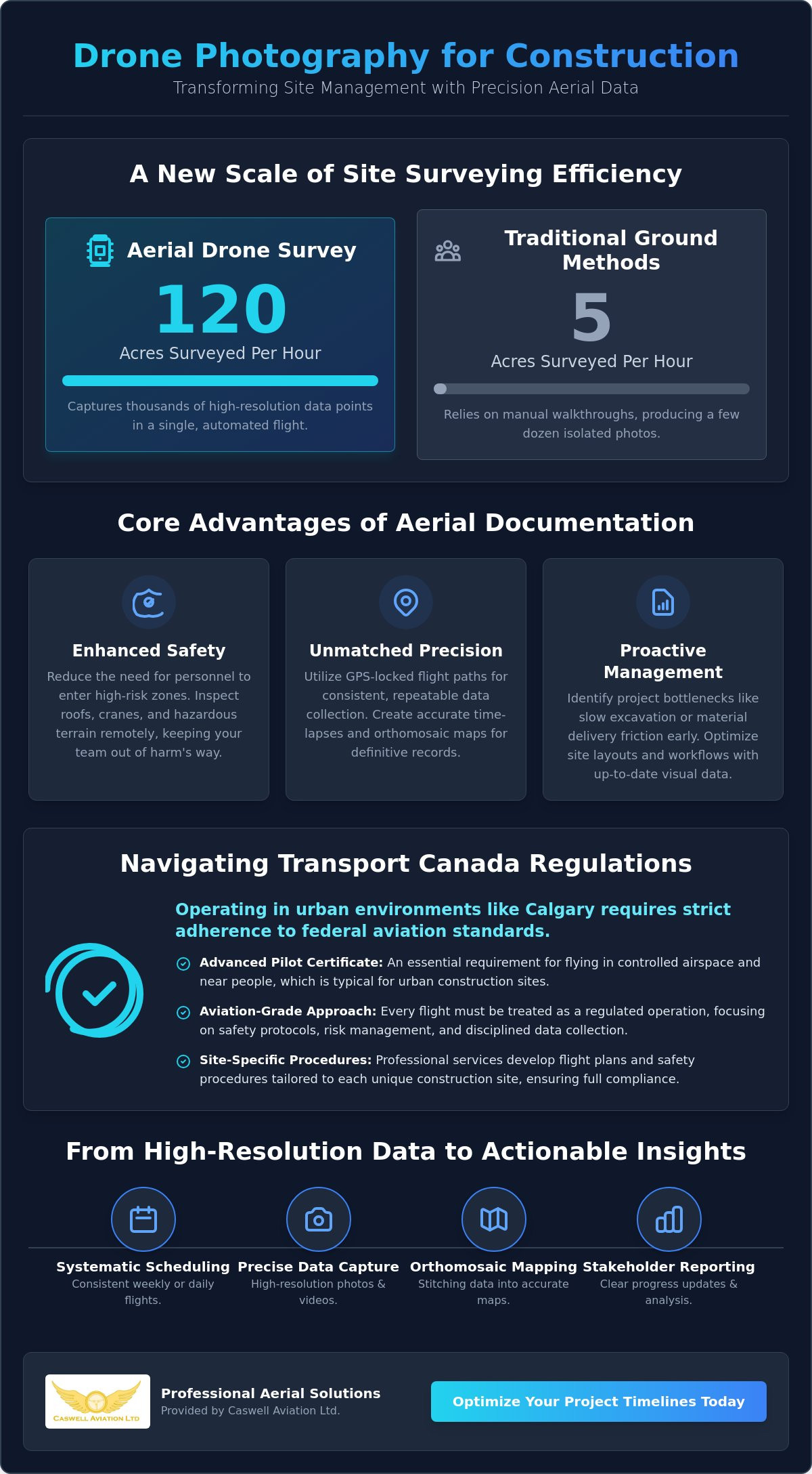
Research indicates that a drone can survey up to 120 acres in a single hour, which is a significant increase over the five acres typically managed by traditional ground methods. For project managers, adopting drone photography for construction Calgary is no longer about novelty; it's about replacing ground-level uncertainty with precision data. You likely recognize the frustration of monitoring a sprawling job site from the perimeter, especially when safety protocols and Transport Canada regulations create additional layers of complexity.
We'll demonstrate how professional aerial imagery transforms site management, ensures strict regulatory compliance, and optimizes project timelines across Canada. This article provides a clear look at how high-resolution progress photos and accurate volume mapping give stakeholders a definitive record of site activity. You'll discover how a disciplined, aviation-grade approach to data collection turns complex site monitoring into a predictable, professional, and highly efficient workflow. By focusing on standards and safety, we can help you bridge the gap between technical requirements and practical site results.
Key Takeaways
- Understand how systematic aerial documentation provides a comprehensive perspective of large-scale sites that traditional ground photography cannot achieve.
- Learn why thousands of high-resolution data points captured during a single flight offer superior site oversight compared to manual ground walkthroughs.
- Identify the specific Transport Canada requirements for urban sites and why an Advanced Pilot Certificate is essential for drone photography for construction Calgary.
- Discover the technical steps for ensuring map accuracy, including the use of Ground Control Points and consistent flight scheduling for reliable data.
- Explore how professional aviation-grade services combine flight training expertise with precise imagery delivery to optimize project timelines and manage risk.
Scaling Efficiency with Drone Photography for Construction in Calgary
Aerial progress tracking has evolved from a luxury into a systematic documentation tool essential for large-scale projects. In a city where development moves quickly, utilizing drone photography for construction Calgary allows project managers to replace fragmented ground-level snapshots with a cohesive, high-resolution overview. This birds-eye view captures spatial relationships that ground photography simply cannot match, such as the proximity of heavy machinery to utility lines or the exact footprint of material stockpiles. It provides a level of clarity that is impossible to achieve from the perimeter of a site.
Adopting an aviation-first mentality is critical for these high-stakes environments. It means treating every flight as a regulated operation rather than a hobbyist activity. By implementing professional aerial photography techniques, firms create a robust historical archive. This data serves as a definitive source of truth for stakeholder reporting and provides the necessary evidence for dispute resolution, should disagreements arise regarding project milestones or site conditions. For firms looking to integrate these standards, Caswell Aviation Ltd provides the technical expertise required to operate safely in complex urban environments.
The Shift from Periodic to Systematic Imagery
Traditional site monitoring often relied on monthly progress reports, which frequently missed the subtle shifts that lead to delays. Shifting to a systematic weekly or daily schedule provides a granular look at the site's evolution. This frequency allows project leads to identify bottlenecks early, such as slow excavation progress or logistical friction in material delivery. When you have a current map of the site, you can optimize where trailers and supplies are placed to maximize worker efficiency. It's a proactive way to maintain project timelines and keep stakeholders informed with factual, visual data. Drone photography for construction Calgary ensures that no phase of the build goes undocumented.
Reducing Site Inspection Risks
Safety is the foundation of any successful project. Drones provide a significant advantage by reducing the need for personnel to enter high-risk zones. Whether it's inspecting a high-rise roof or monitoring crane operations, remote aerial views keep supervisors out of harm's way. This approach doesn't just improve safety; it also streamlines the inspection process. Instead of spending hours climbing scaffolding or navigating hazardous terrain, a qualified pilot can capture the necessary data in minutes. This reduction in manual inspection hours offers clear cost-saving potential while ensuring that safety standards remain high across the entire site.
Comparative Analysis: Aerial Progress Photos vs. Traditional Site Inspections
Traditional site inspections rely on the physical presence of a supervisor walking the grounds with a camera or tablet. This method is inherently limited by the inspector's line of sight and the time required to navigate obstacles. In contrast, drone photography for construction Calgary utilizes automated flight paths to capture a comprehensive dataset from above. While a manual walkthrough might produce a few dozen isolated photos, a single drone mission generates thousands of high-resolution data points. These points are stitched into a single, cohesive record that offers far more than a simple visual check.
The difference in speed is measurable. Research shows that drones can survey up to 120 acres per hour, while traditional methods typically cover only about five acres in the same timeframe. This efficiency allows project managers to reallocate labour to more complex tasks. By using GPS-locked flight paths, we ensure that every photo is taken from the exact same coordinates and altitude every week. This consistency is vital for creating accurate time-lapse sequences that show the build's progression without the jarring shifts in perspective found in handheld photography. It's a disciplined approach that prioritizes precision over guesswork.
Data Accuracy and Orthomosaic Mapping
Engineers require more than just "pretty pictures" to make informed decisions. We provide orthomosaic mapping, which is a geometrically corrected aerial image where the scale is uniform. Unlike standard photos, these maps allow for precise distance and area measurements directly within CAD software. This shift from visual documentation to actionable site data means that volume calculations for stockpiles or site grading can be performed with high confidence. It's a professional standard that transforms a simple image into a technical asset.
Stakeholder Communication and Transparency
Project transparency is a primary concern for remote investors and municipal partners. Cloud-based aerial galleries allow stakeholders to view the site's status from anywhere in the world, which reduces the need for frequent travel. Professional-grade imagery also plays a critical role in municipal progress reports, providing clear evidence of regulatory compliance and milestone completion. If you're looking to enhance your project's transparency with high-resolution data, our drone aerial photography and video services provide the professional standard your stakeholders expect.
Navigating Transport Canada Regulations for Urban Construction Sites
Construction projects in a major city like Calgary present unique regulatory challenges that ground-based teams rarely have to consider. Unlike rural flights, urban drone photography for construction Calgary almost always falls under the "Advanced Operations" category. This classification is triggered when a drone is flown within 30 metres horizontally of bystanders or within controlled airspace. To operate legally in these environments, a pilot must hold a Transport Canada Advanced Pilot Certificate. This certification is a verification that the operator understands the complexities of the Canadian Aviation Regulations (CARs) and can manage the risks associated with flying near workers and infrastructure.
Regulatory compliance also extends to the equipment itself. Operators must use a compliant Remotely Piloted Aircraft System (RPAS) that the manufacturer has declared safe for advanced missions. Maintaining professional standards requires regular flight reviews. These reviews serve as a practical assessment to ensure the pilot remains proficient in emergency procedures and site-specific safety protocols. Choosing a partner who prioritizes these certifications protects your firm from significant fines. Corporations can face penalties of up to $5,000 for flying without a certificate or up to $15,000 for endangering people or aircraft. We prioritize a disciplined approach to ensure every flight meets these legal benchmarks.
Understanding Controlled Airspace in Canadian Cities
Calgary's urban landscape is dotted with controlled airspace zones due to the presence of the Calgary International Airport and numerous hospital heliports. Flying a drone within 5.6 kilometres of an airport or 1.9 kilometres of a heliport without authorization is a violation of federal law. Professional service providers manage this complexity by obtaining NAV CANADA authorization before every flight. This process involves submitting a detailed flight plan and coordinating with air traffic control. When you hire an expert, they handle all the regulatory paperwork and communication. This allows your team to focus on the build while we ensure the drone stays clear of manned aviation.
The Importance of Level 1 Complex Certification
For firms that want to bring these capabilities in-house or ensure their partners meet the highest possible standards, a Level 1 Complex drone certification Canada is the benchmark. This level of training allows for advanced operations in the most demanding environments. It requires a robust safety management system similar to those used in traditional aviation. At Caswell Aviation Ltd, we provide the specialized training and flight reviews necessary to realize these high standards. Our goal is to ensure that every mission is conducted with the discipline and thoroughness that high-stakes construction projects demand.
Best Practices for Organizing Aerial Data and Site Mapping
Capturing high-quality imagery is only the first stage of a professional workflow. To maximize the utility of drone photography for construction Calgary, the resulting data must be organized and processed with technical precision. This ensures that the information is not just a visual record but a reliable asset for engineering and project management. Following a structured set of best practices allows firms to maintain data integrity across the entire project lifecycle.
- Step 1: Establish Ground Control Points (GCPs). For survey-grade accuracy, you must place physical markers with known coordinates across the site. These points allow software to align aerial images with the real-world environment correctly.
- Step 2: Maintain Lighting Consistency. Schedule flights during the same time of day, or during the "golden hour," to ensure consistent shadow patterns. This uniformity is essential for creating clear time-lapse sequences and accurate orthomosaic maps.
- Step 3: Utilize Cloud-Based Hosting. Hosting 3D models and high-resolution panoramas on a cloud platform allows for instant sharing with remote stakeholders. This improves transparency and speeds up the decision-making process.
- Step 4: Integrate with BIM Workflows. Aligning aerial data with Building Information Modelling (BIM) allows for a direct comparison between the digital design and physical progress.
- Step 5: Prioritize Pilot Recency. Conducting regular flight reviews ensures that operators remain proficient in safety protocols and the latest regulatory requirements.
Pilot Readiness and Ergonomics in the Field
Professional drone operations on a busy construction site are physically demanding. Pilots often spend hours standing in challenging terrain while maintaining intense focus on their flight path. To manage this, many professionals use a drone harness for smart controller to distribute weight and provide essential stability. This ergonomic gear reduces physical fatigue and allows for the precise, fluid movements required for high-quality data capture. When an operator is comfortable and stable, the resulting imagery is consistently better. If you need to upgrade your field equipment, you can find professional Fitek Gear drone harnesses designed for long-duration missions.
Integrating Imagery with Project Management Software
Aerial data should be integrated directly into your existing project management tools. Tagging high-resolution photos to specific schedule milestones provides a visual confirmation of progress that text reports cannot replicate. This allows for a "Plan vs. Actual" visual comparison, helping project leads identify deviations from the original design early. Orthomosaic maps realize sub-centimetre accuracy in 2026, providing the technical precision required for modern engineering and volume calculations. This level of detail ensures that drone photography for construction Calgary remains a vital component of a data-driven job site.
Caswell Aviation Ltd: Professional Aerial Solutions for the Canadian Construction Sector
Caswell Aviation Ltd serves as a comprehensive resource for firms requiring aviation-grade data and reliable site documentation. We offer a dual-focus approach that combines professional imagery delivery with high-level technical training. This ensures that whether you outsource your project or manage it internally, the results meet the rigorous standards of the Canadian construction industry. Our commitment to safety culture and regulatory compliance makes us a stable partner for firms operating in Calgary and across multiple provinces. We provide the stability and technical authority needed to manage high-stakes aerial operations with precision.
Choosing a partner for drone photography for construction Calgary requires more than just looking at equipment. It requires a partner who understands the discipline of flight operations and the practical needs of a job site. We bring a culture of thoroughness to every mission, ensuring that data collection is performed without compromising site safety or regulatory standing. Our team operates as a veteran mentor for your project, bridging the gap between complex aviation rules and your daily construction goals.
From Pilot Training to Site Delivery
Many firms choose to build their own internal drone programs to maintain daily oversight of their assets. Caswell Aviation Ltd facilitates this transition by providing Transport Canada drone certification courses tailored to professional applications. We move beyond basic flight skills to focus on the technical requirements of construction site documentation and safety management. Understanding what is a drone flight review Canada and having an expert to guide your team through the process is invaluable for maintaining pilot recency. We provide the training necessary for your staff to become certified, capable, and compliant operators.
Why Safety and Standards Matter for Construction
In a sector where precision is non-negotiable, your aerial partner must act with the discipline of a master practitioner. We prioritize a long-term partnership approach, helping you navigate complex regulatory frameworks and evolving technical options. This methodical style ensures that drone photography for construction Calgary remains a predictable and high-value part of your workflow. We're equally comfortable explaining regulatory frameworks as we are delivering high-resolution 3D models. To discuss your specific project requirements or to schedule a professional site consultation, please Contact Caswell Aviation Ltd today.
Advancing Site Intelligence through Professional Aviation Standards
Implementing drone photography for construction Calgary represents a strategic shift toward data-driven project management. By replacing manual inspections with high-frequency aerial documentation, firms can realize significant efficiency gains and maintain a definitive record of every build phase. This disciplined approach ensures that technical accuracy and regulatory compliance remain at the forefront of your site operations. You've seen how systematic mapping and specialized training reduce risk while providing stakeholders with the transparency they require.
Caswell Aviation provides the technical expertise and safety culture needed to manage these complex requirements. As Transport Canada Advanced Certified Flight Reviewers and a specialized Fitek Gear retailer, we offer the technical authority and ergonomic equipment necessary for professional success. Our national service coverage ensures that your projects receive consistent, aviation-grade imagery and support regardless of the province. We prioritize standards and reliability to help you bridge the gap between modern technology and traditional construction excellence.
To elevate your project oversight and ensure full compliance with Canadian aviation regulations, Book a Professional Construction Site Consultation with Caswell Aviation. We look forward to helping you optimize your project timelines with precision and professional discipline.
Frequently Asked Questions
Do I need a special permit for drone photography for construction in Calgary?
Most construction sites in Calgary require an Advanced Pilot Certificate rather than a specific permit for every flight. Because these sites are often located near bystanders or within controlled airspace, pilots must follow strict federal protocols. You must also obtain NAV CANADA authorization if the site falls within the 5.6-kilometre radius of an airport or 1.9 kilometres of a heliport. Professional providers manage these authorizations as part of their standard workflow.
What is the difference between Basic and Advanced drone certification in Canada?
Basic certification is intended for low-risk operations in uncontrolled airspace, requiring the drone to remain 30 metres away from bystanders. Advanced certification is required for drone photography for construction Calgary because it permits flight in controlled airspace and within 30 metres of people. To obtain an Advanced certificate, a pilot must pass a more difficult exam and complete a practical flight review with an authorized reviewer to demonstrate their proficiency.
How often should drone progress photos be taken on a construction site?
Weekly or bi-weekly flights are the industry standard for maintaining an accurate project record. This frequency allows project managers to identify logistical bottlenecks and verify milestones without overwhelming the data management system. For high-intensity phases like excavation or structural framing, some firms opt for daily flyovers. Consistent scheduling ensures that time-lapse sequences remain smooth and useful for stakeholder reporting and historical documentation.
Can drones fly in controlled airspace near Canadian city centres?
Drones can fly in controlled airspace, but only if the operator holds an Advanced certificate and receives specific NAV CANADA authorization. City centres often have overlapping restricted zones due to hospital heliports and regional airports. Professional operators use specialized software and communication channels to coordinate with air traffic control. This ensures that aerial missions don't interfere with manned aviation while still capturing the necessary high-resolution site data.
What kind of data can drones provide besides just photos?
Drones provide technical datasets including orthomosaic maps, 3D point clouds, and digital elevation models. These assets allow engineers to perform precise distance measurements and volume calculations for material stockpiles. By integrating this data into BIM software, project leads can compare the physical site progress against the original architectural designs. This turns simple visual documentation into a technical tool for detailed site analysis and professional resource management.
How do I verify if a drone pilot is properly licensed by Transport Canada?
You should request a copy of the pilot's "Pilot Certificate - Advanced Operations" issued by Transport Canada. Every certified pilot receives a digital or physical certificate that includes their name and a unique certificate number. You can verify the validity of this certificate through the Transport Canada drone management portal. It's also prudent to confirm that the drone they are using is registered and marked with a visible registration number as required by law.
What happens if a drone pilot flies without an Advanced certificate on a construction site?
Flying without the proper certification exposes both the pilot and the hiring corporation to significant legal liability. Transport Canada can issue fines of up to $5,000 for individuals and up to $15,000 for corporations that permit unauthorized or dangerous flights. Beyond financial penalties, an incident involving an unlicensed pilot could invalidate insurance policies and lead to project shutdowns. Using a certified professional is the only way to manage these regulatory risks effectively.
Does Caswell Aviation offer drone training for my own construction staff?
Yes, we provide both online drone courses and in-person training designed to help your staff achieve their Advanced certification. Our programs focus on the practical application of drone technology within the construction sector, including safety management and flight review preparation. We also offer Advanced and Level 1 Complex flight reviews to ensure your internal pilots meet national standards. This allows your firm to build a compliant and capable internal drone program.
Leave a comment