

Vacation Rental Aerial Photography in Alberta: The 2026 Professional Guide
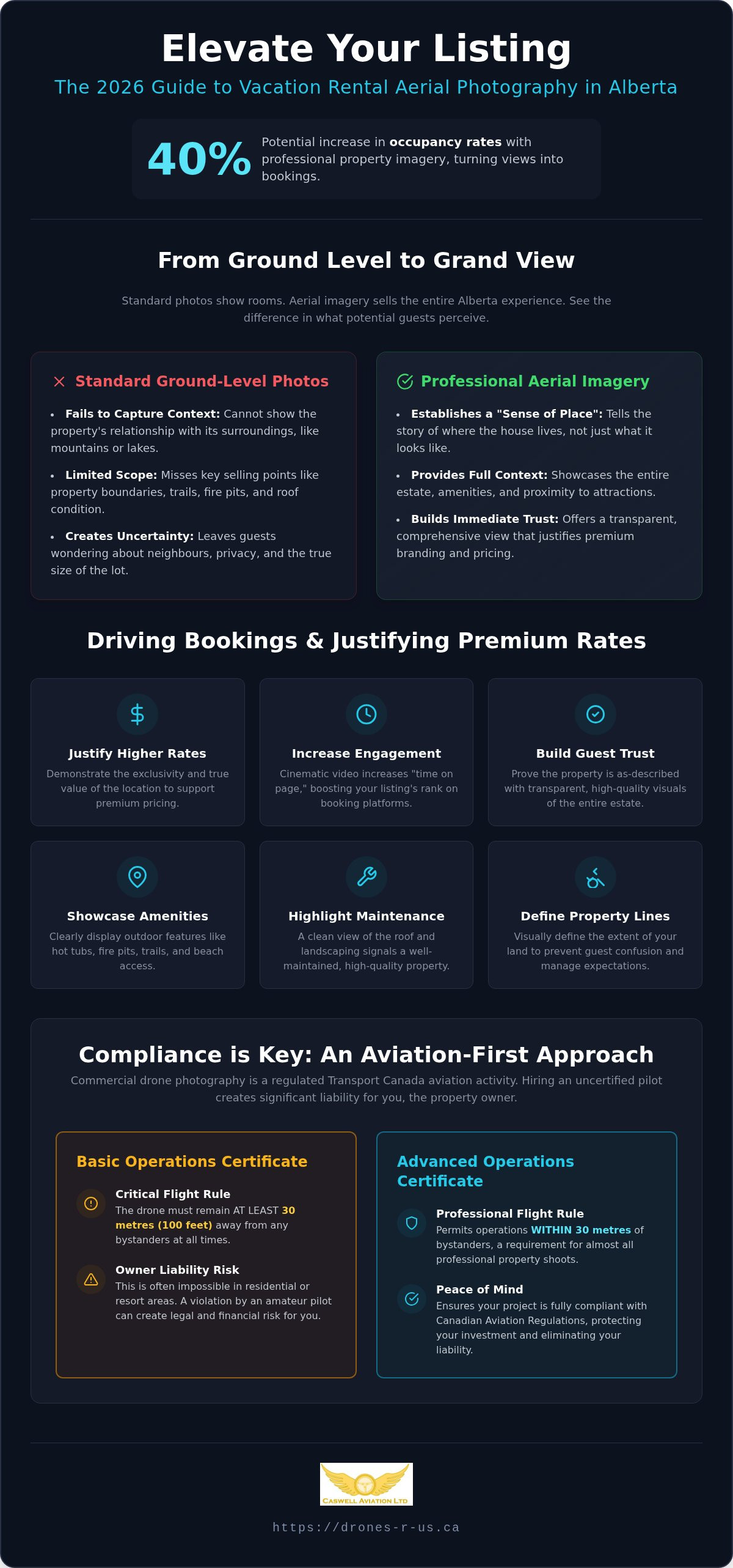
Did you know that professional imagery can increase your vacation rental occupancy rates by as much as 40%? In a market where supply is rising and vacancy rates in major centres remain tight, your listing must do more than just show the rooms. It has to sell the experience of the Alberta landscape. You likely realize that stunning visuals are the key to justifying premium nightly rates, yet the technical and legal hurdles of drone operations often create unnecessary hesitation.
We understand the fear of liability and the confusion surrounding Transport Canada licensing. Professional vacation rental aerial photography Alberta is not merely a creative task; it is a regulated aviation operation that requires precision and discipline. This 2026 guide provides the clarity you need to move forward with confidence. You will learn how to leverage advanced drone imagery to create a high-converting listing while maintaining full compliance with federal and municipal regulations. We will cover everything from pilot certification requirements to the specific bylaws governing mountain regions, ensuring your property media is both beautiful and legally secure.
Key Takeaways
- Understand how Remotely Piloted Aircraft Systems (RPAS) provide a unique sense of place that standard ground-level photography cannot achieve.
- Distinguish between Basic and Advanced Transport Canada certificates to ensure your vacation rental aerial photography Alberta operations remain fully compliant with aviation law.
- Evaluate the return on investment of professional-grade, HDR media versus amateur footage to help justify premium nightly rental rates.
- Follow a modular checklist for property preparation to enhance curb appeal from an aerial perspective while coordinating with guests and neighbours.
- Recognize the value of partnering with a disciplined aviation provider who prioritizes safety-critical standards and zero-incident flight operations.
What is Vacation Rental Aerial Photography in Alberta?
At its core, What is Aerial Photography? is the practice of capturing images from an elevated position. For property owners and managers, this specifically involves the use of Remotely Piloted Aircraft Systems (RPAS) to secure high-resolution exterior and contextual imagery. This media provides a "sense of place" that ground-level photography simply cannot match. We define vacation rental aerial photography Alberta as a strategic fusion of high-impact marketing and strict aviation precision.
The "Alberta Advantage" lies in the province's diverse geography. From the rugged peaks of the Rockies to the vast expanses of the prairies and the dense boreal forests, every property has a unique environmental story. Aerial views allow you to tell that story by showing a cabin's proximity to a lake or a luxury home's relationship with its mountain backdrop. It moves beyond showing what a house looks like; it shows where the house lives.
The Shift to Elevated Perspectives in 2026
Traveller expectations have shifted significantly as the rental market becomes more saturated. In 2026, guests demand full property context before they commit to a booking. They want to see the roof condition, the surrounding forest, and the distance to the nearest neighbour. Standard wide-angle lenses often distort interior spaces and fail to capture the outdoor experience. Professional aerial imagery addresses this gap by providing a realistic, comprehensive view of the entire estate.
Aerial video is also a powerful tool for increasing "time on page" for your listing. When a potential guest watches a smooth, cinematic flyover of a property, they stay engaged longer, which improves your ranking on major booking platforms. This level of detail builds immediate trust. It proves that the property is exactly as described and that the owner invests in professional-grade presentation. For those looking to scale their operations, professional drone imagery has become a prerequisite for success rather than an optional upgrade.
Understanding the Provincial Rental Landscape
The Alberta rental market is increasingly sophisticated, with a strong focus on turnkey properties and lifestyle assets. For investors aiming to acquire such properties, leveraging data from Landvoice helps in identifying pre-foreclosure opportunities that can then be showcased through high-end aerial media. Aerial imagery is essential for highlighting specific outdoor amenities that are otherwise difficult to photograph. This includes:
- Property Boundaries: Clearly defining the extent of the land to prevent guest confusion.
- Outdoor Amenities: Showcasing fire pits, hot tubs, and private trails from a top-down perspective.
- Contextual Proximity: Visualizing the walk to a nearby beach or the drive to a local trailhead.
- Structural Integrity: Providing a clean view of the roof and landscaping that suggests a well-maintained home.
For rural or mountain rentals, these visuals justify premium "luxury" branding. They allow you to charge higher nightly rates by demonstrating the exclusivity of the location. By using a disciplined, aviation-rooted approach, you ensure that these images are captured safely and legally, respecting the privacy of neighbours while maximizing the visual appeal of your own property.
The Aviation-First Approach: Safety and Compliance
Operating a drone for commercial purposes is a serious aviation commitment. Professional vacation rental aerial photography Alberta is more than a creative service; it is a regulated activity governed by Transport Canada under the Canadian Aviation Regulations (CARs) Part IX. Property owners often mistakenly believe that a recreational pilot or a friend with a hobby drone can safely capture their listing. This assumption creates significant legal risk and potential financial liability for the property owner.
The most critical distinction for property owners is the difference between Basic and Advanced operations. A pilot with a Basic certificate must remain at least 30 metres away from any bystanders. In a typical Alberta residential area or a clustered mountain resort, maintaining this 30-metre buffer is often impossible. Therefore, most professional shoots require an Advanced Transport Canada drone pilot certificate. This certification allows the pilot to operate within 30 metres of people, provided they use a drone with the appropriate safety declaration.
Transport Canada Regulations for Commercial Shoots
Any flight conducted for "work" or "hire" is considered a commercial operation in the eyes of the law. This means the pilot must hold a valid certificate and the drone must be registered with the federal government. Hiring an uncertified pilot can invalidate your property insurance if an accident occurs, leaving you personally liable for damages. For a deeper look at these requirements, you can consult our Transport Canada drone certification guide. A Professional Flight Review is the final step in securing an Advanced certificate, ensuring the pilot possesses the technical competency to handle mid-air emergencies and equipment failures.
Navigating Controlled Airspace and Safety Standards
Many desirable rental locations sit within controlled airspace near regional airports or heliports. Professional pilots do not simply take off; they must coordinate with NAV CANADA to receive specific flight authorization. This process includes a thorough pre-flight risk assessment to identify hazards such as power lines, high-wind corridors, or neighbouring privacy concerns. Precision is vital during these operations. We often utilize specialized equipment like a drone harness for smart controllers to maintain stable, fatigue-free control during complex manoeuvres near structures.
Liability rests with the property owner when safety is overlooked. Ensuring your photographer follows a disciplined aviation framework protects your investment and your reputation. If you require a professional flight review or wish to verify a pilot's credentials, our team provides comprehensive aviation training to ensure your operations remain fully compliant.
Professional vs. Amateur: Calculating the Real ROI
Investing in vacation rental aerial photography Alberta is a decision rooted in performance data. Industry data on real estate photography ROI suggests that high-quality visuals lead to higher perceived value and faster conversions. For a rental owner, this translates to higher occupancy rates and the ability to command premium nightly fees. An amateur "hobbyist" photo often looks flat or distorted. In contrast, a professional HDR composite captures the true, vibrant colours of the Alberta landscape, making your property stand out in a crowded digital marketplace.
The "Master Practitioner" advantage involves more than just owning a drone. It requires technical precision in framing and a deep understanding of natural lighting. Professional pilots often wait for the "golden hour" or use specialized filters to manage the harsh glare common in mountain environments. These assets provide long-term value. You can use them across social media, your direct booking website, and even high-end print brochures. High-quality media isn't an expense; it's a foundational part of your marketing infrastructure.
The Risks of Unlicensed Operators
Choosing an unlicensed operator to save a few dollars is a high-risk gamble. Transport Canada can issue substantial fines to both the pilot and the party that hired them for illegal commercial work. Beyond the legal fees, a single drone accident on your property can devastate your business reputation. Insurance providers may deny claims if they discover the operator was uncertified. "Cheap" photography quickly becomes your most expensive mistake when you factor in these potential liabilities and the cost of re-shooting poor work.
Image Quality and Brand Consistency
Professional media relies on high-bitrate video and RAW photography. These formats allow for extensive colour-correction and detail recovery during the editing process. Amateurs often deliver compressed files that lose detail in the shadows or blow out the highlights. Maintaining a consistent look and feel across your entire rental portfolio is essential for your brand identity. A professional pilot understands how to replicate specific styles, ensuring your listings look cohesive, trustworthy, and elite. This level of technical discipline ensures your media remains relevant and sharp for years to come.
Preparing Your Property for an Aerial Photography Session
Achieving the best results from vacation rental aerial photography Alberta requires more than just a skilled pilot; it requires a property that is staged specifically for the sky. Traditional curb appeal focuses on the view from the street, but drone imagery reveals everything from the condition of the gutters to the arrangement of the backyard patio. To ensure a professional finish, property owners must adopt a disciplined approach to staging that considers the unique top-down perspective. By following a structured preparation plan, you ensure that your vacation rental aerial photography Alberta project results in high-impact media that justifies your investment.
Communication is a vital part of the pre-flight process. We recommend notifying neighbours of the scheduled flight time to address privacy concerns and ensure a smooth operation. Privacy is non-negotiable. If the property is currently occupied, coordinating with guests is essential to provide a clear, private environment for the shoot. You should remove all non-aesthetic vehicles, trailers, and maintenance equipment from the property exterior to avoid distracting from the architectural features.
The Pre-Flight Property Checklist
Staging for the air involves specific tasks that ground-level photographers might overlook. Ensure that all outdoor furniture is uncovered and neatly arranged. Pools and hot tubs should be clean, open, and clear of debris. Lawns must be freshly mowed, as high-resolution drone sensors easily pick up uneven grass or stray branches. If you are planning for evening "twilight" shots, verify that all exterior lighting, including pathway lights and pool features, is fully functional. These small details signal a well-maintained home to potential guests.
Choosing the Right Time and Conditions
Alberta's weather is notoriously unpredictable. Timing is everything. We monitor wind speeds and visibility closely to ensure optimal flight safety and image clarity. The "Golden Hour" just after sunrise or before sunset is the preferred window for capturing the warm, directional light that defines the Alberta landscape. This timing avoids the harsh, vertical shadows of midday that can obscure important architectural details and make outdoor spaces look uninviting.
The season dictates the narrative of your listing. A property marketed for winter skiing requires clear views of snow-dusted pines and cleared driveways, while a summer rental focuses on lush greenery and vibrant outdoor living spaces. We adjust our flight plans to account for these seasonal shifts, ensuring the property is presented in its most appealing state for the target audience. If you are ready to elevate your listing with high-resolution imagery, book your professional drone aerial photography with our team today.
Caswell Aviation: Your Partner in Professional Aerial Solutions
Caswell Aviation operates with a level of discipline rooted in high-stakes aviation. We don't just provide vacation rental aerial photography Alberta; we deliver a comprehensive service built on years of experience as aviation educators and technicians. Our status as Master Practitioners means every operation is treated with the same precision as a manned flight. We maintain a zero-incident record by strictly adhering to the regulatory frameworks established by Transport Canada. This commitment to safety-critical standards protects your property and your professional reputation from the risks associated with amateur operators.
Our Aviation-First Methodology
Our training background ensures every flight follows airline-standard safety protocols. Working with pilots who also conduct professional flight reviews gives you a distinct advantage. These experts understand the limitations of the hardware and the nuances of the Canadian Aviation Regulations far better than a standard photographer. Because we have mastered the technical side of flight, we can focus on capturing more creative and daring shots. We understand exactly how far a drone can safely be pushed to get the perfect angle without compromising the mission. This technical authority allows us to navigate complex Alberta environments that others might avoid.
Training Your Own Team for Large-Scale Operations
For property management companies overseeing multiple estates across the province, we offer the ability to bring drone operations in-house. Caswell Aviation provides customized training programs designed to help your internal staff obtain their Advanced certification. We don't just teach the basics of flight; we instill a culture of discipline and thoroughness. We provide ongoing support and specific equipment recommendations to ensure your team achieves professional-grade results consistently. This often includes ergonomic solutions for pilots, such as specialized harnesses, to ensure safety and precision during extended field operations.
Whether you need a single, high-resolution shoot or a full-scale training solution for your organization, we provide the stability and expertise required for success. Our imagery packages are tailored to the unique scale of Alberta properties, from sprawling mountain estates to modern urban rentals. Visit the Caswell Aviation homepage to discuss your specific requirements and secure a partner who values aviation compliance as much as you value high-converting media.
Securing Your Competitive Edge with Professional Aerial Imagery
The Alberta vacation rental market in 2026 demands more than standard marketing. High-resolution imagery is now a prerequisite for justifying premium nightly rates and maintaining high occupancy. By choosing professional vacation rental aerial photography Alberta, you ensure that your property is presented with technical precision while remaining fully compliant with Transport Canada regulations. This disciplined approach protects your investment from liability and sets a standard for quality that amateur footage cannot match.
As Transport Canada Advanced Certified pilots and Professional Flight Reviewers, we bring a culture of aviation safety to every project. We understand the complex regulatory environment and use specialized Fitek Gear to maintain the highest levels of control during flight. Our commitment to zero-incident operations provides the peace of mind you need to focus on managing your guests. It's time to transform your listing into a high-converting asset that captures the true essence of the landscape.
Book Your Professional Aerial Photography Session with Caswell Aviation and experience the difference that aviation expertise makes to your brand. We look forward to helping you showcase your property from a superior perspective.
Frequently Asked Questions
Do I need a special permit for drone photography at my Alberta rental?
You generally don't need a specific provincial permit for flights over private property, but you must strictly follow Transport Canada's CARs Part IX regulations. If your rental is located near a provincial or national park, federal prohibitions apply without a specific commercial permit. Many municipalities also require landing and launch authorizations for city-owned land. Always verify the airspace classification with NAV CANADA to determine if a flight authorization is required before beginning any vacation rental aerial photography Alberta project.
Is aerial photography safe to perform near my guests or neighbours?
Safety depends entirely on the pilot's certification and the safety declaration of the equipment. Pilots holding an Advanced certificate can operate within 30 metres of bystanders, provided they use declared safety systems. We conduct thorough pre-flight risk assessments to identify hazards like power lines or high winds. Communicating with neighbours before the shoot is a standard professional practice that ensures privacy and minimizes concerns. Our disciplined approach prioritizes a zero-incident environment for everyone on or near the property.
How much does vacation rental aerial photography typically cost in Alberta?
Pricing for professional aerial imagery varies based on the property's scale, location complexity, and the specific deliverables required. High-end mountain estates often require more flight time and specialized editing compared to smaller urban listings. While hobbyist rates might seem attractive, they rarely include the necessary liability insurance or Advanced certification required for legal commercial work. Investing in professional media ensures you receive high-bitrate, colour-corrected assets that justify premium nightly rental rates and improve listing conversion.
What happens if the weather is bad on the day of the scheduled shoot?
We monitor wind speeds, precipitation, and visibility closely leading up to your session. If conditions exceed safe operating limits or significantly degrade image quality, we'll reschedule the shoot for the next available window with optimal lighting. Aviation safety is our primary concern, and flying in high winds or low visibility risks both the equipment and the property. We aim for the "Golden Hour" to ensure your rental looks its absolute best in natural light.
Can I use drone photos to show the distance to local attractions?
Aerial imagery is the most effective way to visualize your property's proximity to lakes, trails, or mountain ranges. High-altitude contextual shots provide a "sense of place" that ground-level photos cannot replicate. This helps potential guests understand the layout of the area and the convenience of your location. We can capture wide-angle perspectives that highlight these boundaries and amenities, making your vacation rental aerial photography Alberta more informative and persuasive for travellers looking for specific lifestyle experiences.
How long does a typical aerial photography session take for a rental property?
A standard session typically takes between 60 and 90 minutes on-site. This timeframe allows for a full pre-flight safety briefing, site inspection, and multiple flight patterns to capture various angles and lighting conditions. More complex properties or those requiring cinematic video flyovers may take longer to ensure every architectural detail is documented. We work efficiently to minimize disruption to your operations while maintaining the disciplined standards required for high-quality, professional media production and regulatory compliance.
Do you provide both raw footage and edited final products?
Our standard delivery includes fully edited, colour-corrected, high-resolution images and stabilized video files. We utilize professional post-processing techniques to ensure the final media matches your brand's aesthetic and highlights the property's best features. While we primarily focus on delivering polished, ready-to-use assets, we can discuss providing raw files for specific large-scale marketing projects. Our goal is to provide a turnkey solution that allows you to update your listing immediately with premium, high-converting content.
What is the difference between a basic and advanced drone pilot certificate?
The primary difference lies in where you can fly and how close you can get to people. A Basic certificate limits pilots to uncontrolled airspace and requires a 30-metre distance from bystanders. An Advanced certificate allows for operations in controlled airspace and closer proximity to people, which is often necessary for rental properties in populated areas. Obtaining an Advanced certificate requires passing a more difficult exam and completing a professional flight review to demonstrate technical competency under pressure.
Leave a comment