

Construction Drone Photography in Calgary: The 2026 Professional Progress Tracking Guide
If your drone pilot lacks the proper certification for Calgary’s controlled airspace, your site documentation isn't just a liability. It's potentially illegal. Managing a complex project in Alberta requires absolute precision, and you likely recognize that poor-quality aerial data can lead to miscommunication or expensive rework. This 2026 guide will teach you how to implement professional construction drone photography in Calgary while maintaining full Transport Canada compliance. You'll learn to navigate the strict requirements for operating near urban centres and how to generate data accurate enough for reliable earthworks measurements. We will cover the specific pilot certifications required for 2026, including the latest Level 1 Complex operations. We also detail the municipal permits needed for local sites and the technical workflows that turn raw imagery into high-level project intelligence for your stakeholders. By following these professional standards, you ensure that every flight provides tangible value without compromising site safety or federal law.
Key Takeaways
- Learn how to utilize Ground Control Points (GCPs) and orthomosaic mapping to transform raw aerial imagery into high-accuracy, measurable site maps.
- Understand the 2026 Transport Canada requirements for construction drone photography Calgary, specifically regarding Advanced Pilot Certificates in controlled urban airspace.
- Discover the role of Standard Operating Procedures (SOPs) in mitigating pilot fatigue and maintaining a high standard of safety on active worksites.
- Identify the strategic advantages of transitioning from traditional ground surveys to high-frequency aerial progress reports for improved stakeholder transparency.
- Evaluate the benefits of partnering with a provider that combines professional flight services with Transport Canada-compliant training and certification.
The Evolution of Site Documentation: Why Drones are Essential for Canadian Construction
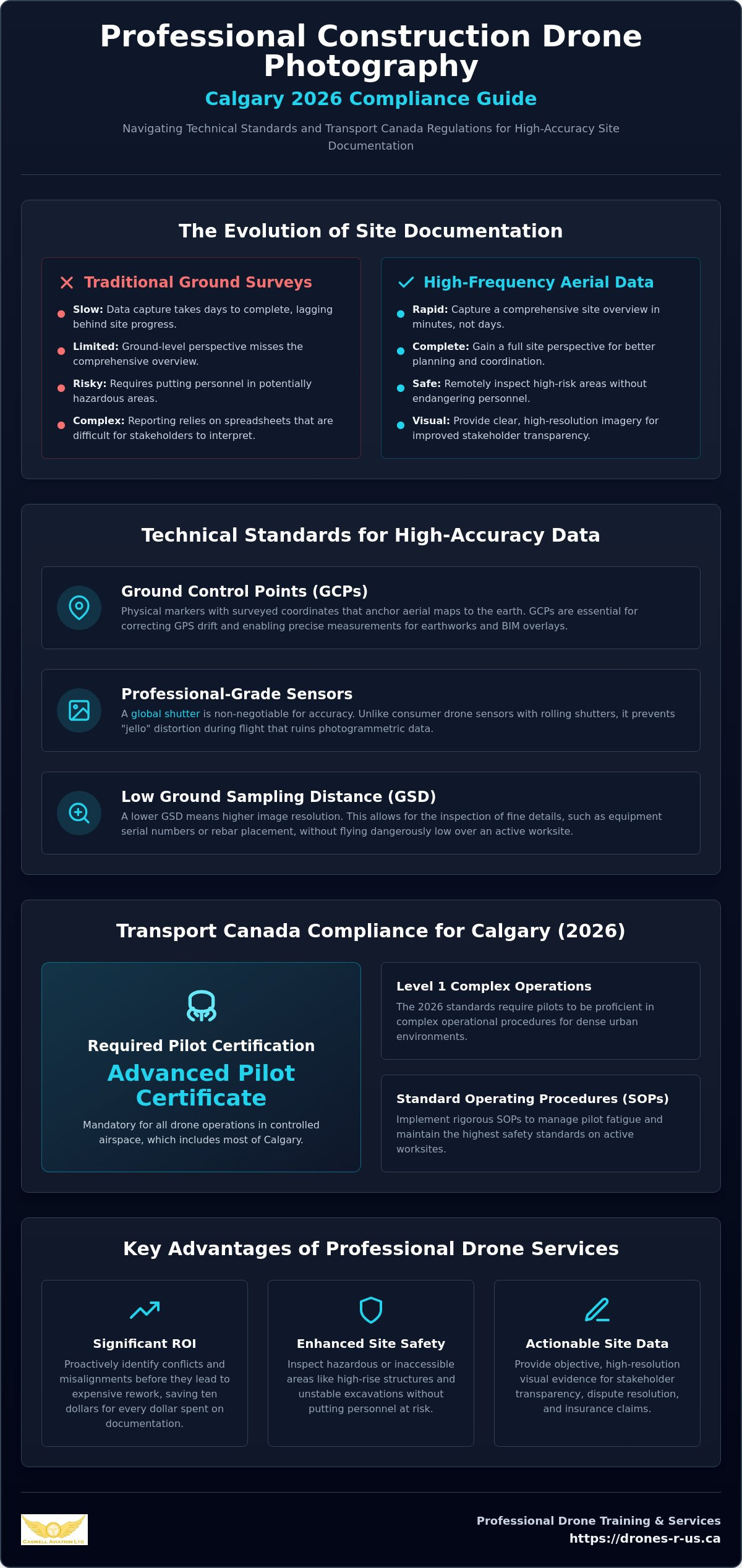
Traditional ground-based surveys often struggle to keep pace with the rapid changes on a busy Alberta site. The Evolution of Site Documentation has moved from manual measurements to high-frequency aerial data collection. This shift allows project managers to capture a comprehensive overview of the site in minutes rather than days. By capturing data from above, teams gain a perspective that ground crews simply cannot replicate without significant time and equipment.
Transparency with stakeholders is improved through visual data that is easy to interpret. Instead of relying on complex spreadsheets or verbal updates, clients can see the physical progress of the build through high-resolution imagery. Safety is another primary driver for adoption. Drones allow teams to inspect hazardous areas, such as high-rise crane components or unstable excavations, without putting personnel at risk. This remote capability is a cornerstone of modern safety-critical operations on a professional worksite.
In addition to aerial views, many firms enhance their safety protocols by using permanent site monitoring. For instance, Jobcam offers solar-powered surveillance towers that provide a continuous visual record, illustrating how remote sites can maintain security and oversight 24/7 between drone missions.
Implementing construction drone photography Calgary provides a clear return on investment by identifying scheduling conflicts before they escalate. When you compare current site conditions against your original blueprints on a weekly basis, the likelihood of expensive rework drops. It's about catching a minor misalignment in a foundation or a utility trench before it's covered by concrete. This proactive approach keeps projects on schedule and ensures that every dollar spent on documentation saves ten dollars in potential rework.
From Marketing Photos to Actionable Site Data
Professional site documentation is distinct from simple marketing photography. While aesthetic shots look good in brochures, technical data supports dispute resolution and insurance claims with objective evidence. By integrating this imagery into project management software, teams can track volumetric changes and as-built conditions with high precision. This level of detail is vital when verifying subcontractor work or documenting site conditions for legal protection. If you are looking to build these capabilities internally, drones-r-us.ca provides the professional training and equipment needed to meet industry standards.
The Environmental and Economic Benefits of RPAS
Using Remotely Piloted Aircraft Systems (RPAS) offers a significantly lower carbon footprint than hiring traditional fixed-wing aircraft or helicopters. These tools provide rapid deployment capabilities, which is essential for urgent inspections after severe weather events. For multi-year infrastructure projects, scaling drone services is far more cost-effective than traditional methods. It ensures consistent data collection across the entire lifecycle of the build, from initial site clearing to final landscaping. This efficiency makes it an essential tool for any modern construction firm in Alberta looking to optimize their operations.
Technical Standards for High-Accuracy Aerial Progress Reports
Technical excellence in construction drone photography Calgary requires more than a high-end camera. It relies on a rigorous data collection framework that ensures every pixel corresponds to a verifiable coordinate on the ground. Professional operators use Ground Control Points (GCPs) to anchor aerial maps to the earth's surface. Without these physical markers, your digital site map may look correct but will fail when used for precise measurements or overlaying Building Information Modelling (BIM) files. Specialized BIM and VDC studios like CRAYDL rely on this high-precision data to integrate aerial captures into comprehensive virtual design and construction workflows. These points are surveyed into the site, allowing the software to correct for GPS drift and altitude variances.
Sensor quality is a non-negotiable factor for professional results. Using sensors with global shutters is a requirement for high-accuracy work because rolling shutters, found in many consumer drones, create "jello" distortion during flight. This distortion ruins the photogrammetric process. High-resolution sensors allow for a lower Ground Sampling Distance (GSD). This means you can see smaller details, such as the serial numbers on equipment or the exact placement of rebar, without flying dangerously low. If you need help choosing the right equipment or understanding these technical requirements, exploring professional training options can bridge the gap between basic flight and technical survey-grade data.
Capture frequency should align with your project's pace. While milestone-based documentation is useful for final handovers, weekly captures have become the industry standard in Alberta. This frequency provides enough data to identify trends in earthworks or structural progress without overwhelming your project management team. For high-intensity urban infill projects, daily flights may be necessary to manage tight logistics and subcontractor coordination.
Photogrammetry vs. Standard Aerial Photography
Photogrammetry is the science of making measurements from photographs. It turns hundreds of 2D images into a single, high-resolution 3D site model. This process requires high-overlap flight paths, often 80% front-lap and 70% side-lap, to ensure data integrity. Unlike standard aerial photos, these models allow you to calculate the volumes of stockpiles and excavation pits with high precision. It transforms a simple visual update into a functional tool for quantity surveyors and project engineers.
Deliverable Formats for Construction Stakeholders
Standardizing file types is essential for seamless integration into existing workflows. Architects and engineers typically require GeoTIFFs for orthomosaic maps or .OBJ files for 3D point clouds. For owners and non-technical stakeholders, 360-degree panoramas provide an immersive site walkthrough that is easy to navigate on a tablet or desktop. Generating time-lapse videos from consistent flight paths also creates a valuable project history archive for future maintenance or marketing needs.
Navigating Transport Canada Regulations for Construction Site Airspace
Safe construction drone photography Calgary relies on a clear understanding of federal aviation law. In Canada, drone operations are governed by Transport Canada under Part IX of the Canadian Aviation Regulations (CARs). These rules divide operations into two main categories: Basic and Advanced. While Basic operations are permitted in uncontrolled airspace away from bystanders, the reality of the Calgary market is that most commercial sites require an Advanced Pilot Certificate. This is because a significant portion of the city lies within controlled airspace or near built-up areas where people are present.
Operating in controlled airspace, such as the zones surrounding Calgary International Airport or Springbank Airport, requires more than just a certificate. Pilots must obtain formal authorization from NAV CANADA before every flight. This process involves submitting a flight plan through the NAV Drone platform and receiving a digital or verbal clearance. Attempting to fly without this authorization is a serious breach of aviation safety. It can result in heavy fines for both the pilot and the hiring firm, potentially halting project progress and damaging professional reputations.
Liability is a critical concern for general contractors and project owners. Hiring a "hobbyist" or an unlicensed pilot to save on costs creates a massive insurance gap. Most commercial liability policies for construction projects will not cover incidents involving an aircraft if the operator was not properly certified or if the flight was conducted in violation of Transport Canada regulations. A professional partner ensures that every flight is fully compliant, providing the necessary documentation to satisfy safety auditors and insurance underwriters.
The Importance of the Advanced Flight Review
An Advanced Pilot Certificate requires more than just a written exam. Candidates must also pass a professional flight review to demonstrate their technical proficiency and knowledge of emergency procedures. You can find more detail on this process in our guide on what is a drone flight review Canada. Beyond the certificate, professionals must maintain a compliant pilot log and a detailed maintenance record for their aircraft. These records are essential for proving due diligence in the event of a site audit or safety incident.
Managing Complex Airspace Near Urban Centres
Calgary's urban landscape features several heliports, including those at major hospitals, which add another layer of complexity to flight planning. Pilots must remain vigilant for low-level emergency medical flights and be prepared to yield the right-of-way immediately. Furthermore, flying "near people" (within 30 metres horizontally) requires a drone that has a manufacturer’s RPAS Safety Assurance for that specific type of operation. To operate under Transport Canada Part IX for Advanced Operations, a pilot must be at least 16 years of age, pass the Advanced online exam, and successfully complete a flight review with a qualified reviewer.
Operational Excellence: Managing Pilot Fatigue and Site Safety
Operational excellence in construction drone photography Calgary requires a disciplined approach to field safety. While regulatory compliance is the baseline, the physical and mental state of the pilot determines the final data quality. Long missions on active sites are taxing. Fatigue leads to missed details or, worse, safety incidents. A professional operator understands that maintaining a high level of situational awareness is as important as the flight itself. This discipline ensures that the site remains safe and the data remains accurate throughout the project lifecycle.
A Visual Observer (VO) is a critical component of a professional crew. In complex urban environments, the pilot must focus on the telemetry and the sensor. The VO maintains a line of sight on the surrounding airspace and ground activity. This division of labour reduces the cognitive load on the pilot. Standard Operating Procedures (SOPs) provide a repeatable framework for every launch, ensuring no safety steps are skipped. These procedures include emergency landing protocols and clear communication channels with site personnel.
Utilizing professional gear is another way to maintain focus during long flight missions. When a pilot is comfortable, they can dedicate more attention to the flight path and data collection. If you want to ensure your operations meet these professional standards, view our advanced training and flight services for your next project.
Ergonomics for the Professional Drone Pilot
Professional pilots often fly multi-battery missions that can last several hours. Relying on a standard neck strap is insufficient for these long durations. It places undue strain on the cervical spine and leads to physical fatigue. Using a professional drone harness for smart controller distributes the weight of the hardware across the shoulders and torso. Fitek Gear improves controller stability, allowing for more precise stick movements during delicate manoeuvres. This stability is essential when capturing high-accuracy progress data near site obstructions.
Pre-Flight Checklists for Industrial Sites
Industrial environments present unique challenges like electromagnetic interference (EMI). Large cranes, power lines, and metal structures can disrupt the drone’s compass or signal. Pilots must assess these risks during the pre-flight phase. Weather minimums are also tighter in urban canyons where wind shear can be unpredictable. Effective communication with site supervisors and heavy equipment operators is mandatory. Every member of the site team should know when a flight is in progress to maintain a safe working environment. This coordination prevents conflicts with other high-stakes site activities.
Selecting a Drone Partner: Training vs. Service Delivery
Selecting a drone partner for your Calgary project requires a balance between immediate results and long-term capability. Many firms begin by outsourcing their construction drone photography Calgary needs to ensure they meet the technical and regulatory standards discussed in previous sections. However, as projects scale, the conversation often shifts from simple service delivery to building an internal drone programme. A provider who offers both flight services and professional instruction is uniquely positioned to guide this transition. Caswell Aviation Ltd doesn't just deliver a map; they provide the framework for your team to eventually generate that data themselves.
When you evaluate a potential partner, their safety record and certification level are the primary indicators of their competence. In the 2026 regulatory environment, a provider should hold an Advanced Pilot Certificate at minimum. If they are also conducting Transport Canada drone certification training, it demonstrates a deeper level of authority. This dual expertise ensures that the pilots on your site are not just hobbyists with a camera, but aviation professionals who understand the discipline of flight operations. They bring a culture of safety that protects your project from liability while delivering high-accuracy data.
Transitioning from outsourced services to an in-house programme is a logical step for many large-scale developers in Alberta. This move allows for daily captures and immediate site inspections without waiting for a third-party schedule. To succeed, your team must be prepared with the proper training and a clear understanding of the CARs Part IX requirements. Investing in your staff's education ensures that your internal operations remain as compliant and efficient as a professional service provider.
Building Internal Capacity with Professional Training
Moving your drone operations in-house requires moving your staff beyond basic flight to Advanced and Level 1 Complex operations. Choosing between online courses and in-person flight training depends on your team's existing experience and the complexity of your sites. Online modules offer convenience for theoretical knowledge, but in-person training is essential for mastering the practical handling of hardware in complex urban environments. Professional flight reviews for corporate teams serve as a final validation of your internal safety protocols and technical proficiency.
The Caswell Aviation Ltd Approach to Construction
Professional construction drone photography Calgary is most effective when it combines high-quality imagery with expert-led education. Our approach supports your project from the first flight to the final handover. We provide support for specialized gear and hardware maintenance, ensuring your equipment remains flight-ready and your data remains precise. This holistic support model helps you avoid the common pitfalls of starting a new technical department from scratch. If you are ready to enhance your site documentation, contact Caswell Aviation Ltd for professional drone services and training to discuss your specific project requirements.
Advancing Your Site Intelligence for 2026 and Beyond
Implementing a professional framework for construction drone photography Calgary ensures that your project data is both measurable and legally compliant. You now recognize that high-accuracy progress tracking requires more than just a camera; it demands Ground Control Points, specialized sensors, and a pilot with an Advanced Pilot Certificate. Maintaining safety on a busy worksite is achieved through rigorous Standard Operating Procedures and ergonomic tools that mitigate pilot fatigue during long missions.
Caswell Aviation Ltd bridges the gap between raw data collection and professional aviation standards. As Transport Canada Advanced and Level 1 Complex Flight Reviewers, we provide the technical expertise required for complex urban operations. We are also an authorized Fitek Gear retailer, ensuring your team has the hardware necessary for sustained focus in the field. Whether you require immediate aerial documentation or a structured path to internal certification, our team is ready to support your project goals.
Contact Caswell Aviation Ltd for Professional Drone Services and Training today to secure your site’s future. We look forward to helping you master the skies over your next build.
Frequently Asked Questions
Do I need a special licence for construction drone photography in Canada?
Yes, you must hold a Pilot Certificate - Small Remotely Piloted Aircraft (VLOS) issued by Transport Canada. Because most construction drone photography Calgary projects occur in urban centres or near bystanders, an Advanced Pilot Certificate is usually mandatory to remain compliant with federal law. This certification ensures the pilot understands the complex regulatory requirements of operating in a high-stakes environment.
Can drones fly in controlled airspace over a construction site?
Drones can operate in controlled airspace provided the pilot holds an Advanced Pilot Certificate and secures authorization from NAV CANADA. The pilot must submit a flight plan through the NAV Drone platform and receive a digital or verbal clearance before takeoff. This process coordinates the drone flight with manned aviation to prevent mid-air conflicts.
What is the difference between an Advanced and Basic drone certificate?
A Basic certificate limits operations to uncontrolled airspace and requires the pilot to stay at least 30 metres away from bystanders. An Advanced certificate allows for operations in controlled airspace and flying within 30 metres of people, or even over them, if the drone has the required safety assurance. Most professional construction documentation in Alberta requires an Advanced certificate due to site proximity to people and airports.
How much liability insurance should a drone pilot have for construction work?
Professional operators should carry between $2 million and $5 million in aviation-specific liability insurance. While Transport Canada has a lower legal minimum, most general contractors in Calgary require higher coverage levels to mitigate the risks associated with active worksites. You should always verify that the policy specifically covers commercial drone operations rather than general business activities.
What happens if a drone pilot flies without NAV CANADA authorization?
Flying in controlled airspace without authorization is a serious violation of the Canadian Aviation Regulations. Transport Canada can issue fines of up to $5,000 for individuals and $25,000 for corporations. Beyond financial penalties, unauthorized flights create significant legal liability for the project owner and can result in the immediate suspension of the pilot's certificate.
How do drones handle interference from cranes and steel structures?
Large metal structures and cranes can cause electromagnetic interference (EMI) that disrupts a drone’s internal compass and GPS. Professional pilots use aircraft with redundant sensors and perform a thorough site survey to identify EMI sources before launching. They also maintain a safe buffer distance from heavy equipment to ensure signal stability and flight safety.
Are drone pilots required to wear specific safety gear on-site?
Drone pilots must follow the same Personal Protective Equipment (PPE) standards as any other worker on an active construction site. This typically includes a CSA-approved hard hat, high-visibility vest, safety glasses, and steel-toed boots. Following these protocols ensures the pilot is protected while focusing on the technical demands of the flight mission.
What is an orthomosaic map and why is it used in construction?
An orthomosaic map is a high-resolution aerial image created by stitching together hundreds of individual photos. It is geometrically corrected to remove lens distortion, allowing for accurate measurements of distance and area. Construction teams use these maps for precise site planning, earthworks volume tracking, and verifying as-built conditions against original blueprints.
Leave a comment