

Risk Assessment for Drone Operations: A Professional Canadian Checklist (2026)
A safe flight begins long before your motors spin up. Treating a risk assessment for drone operations as mere administrative paperwork is the fastest way to invite equipment damage, flyaways, and corporate fines reaching up to $15,000 under Transport Canada enforcement. In professional aviation, disciplined safety management is never an afterthought. It's the primary barrier protecting your flight crew, your high-value payloads, and bystanders on the ground.
You already know how quickly real-world field conditions can shift, and lingering uncertainty about site survey documentation requirements under CAR 901.27 creates unnecessary friction during busy operations. You shouldn't have to second-guess whether your pre-flight hazard controls would withstand a Transport Canada audit or flight review. This professional checklist gives you an actionable, repeatable workflow to master site surveys, mitigate operational risks, and maintain full Canadian Aviation Regulations compliance across every mission you fly.
Key Takeaways
- A structured risk assessment for drone operations transforms standard compliance under Canadian Aviation Regulations Part IX into an audit-ready safety protocol.
- Rigorous pre-flight planning ensures crew recency, fitness, and NAV CANADA airspace coordination are fully resolved before deployment.
- Dynamic on-site surveys delineate clear safety perimeter zones to protect flight crew, bystanders, and mission-critical payloads from physical hazards.
- Standardized mechanical and avionics checks isolate hardware failure points, from compass interference to structural stress, prior to takeoff.
- Pre-established contingency workflows for lost-link and flyaway events deliver rapid, decisive coordination with air traffic authorities during an emergency.
Fundamentals of RPAS Risk Assessment Under Transport Canada Regulations
An operational risk assessment for an unmanned aerial vehicle (UAV) systematically identifies hazards, evaluates potential consequences, and applies practical controls before flight. In Canadian airspace, a defensible risk assessment for drone operations separates air risk, such as mid-air collisions with crewed aircraft, from ground risk to people and critical infrastructure. Commercial pilots who rigorously document these distinctions protect their flight crews from civil liability while maintaining an uncompromised margin of safety.
Regulatory Foundations in the Canadian Aviation Regulations
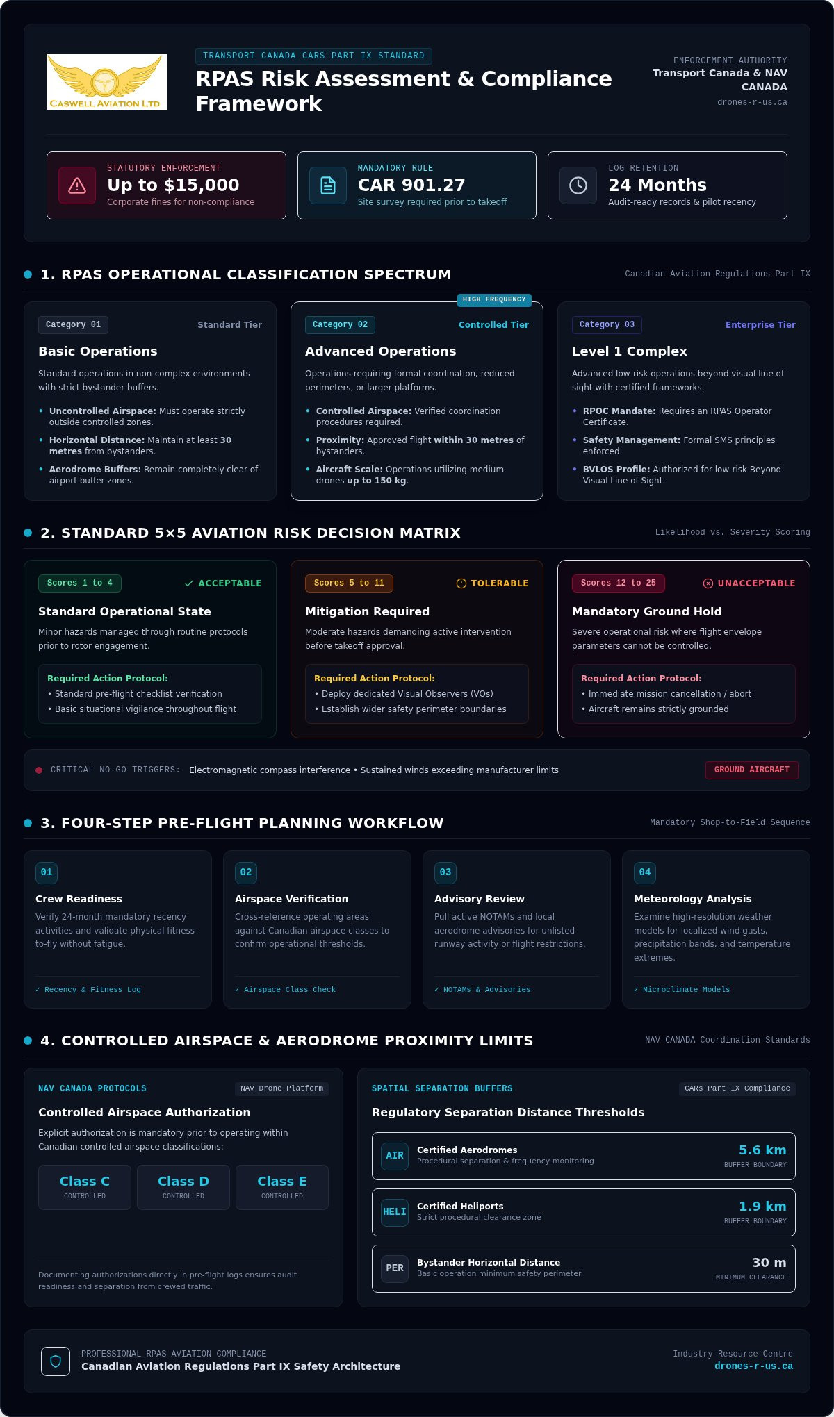
Under Canadian Aviation Regulations (CARs) 901.27, completing a documented site survey is a legal requirement prior to launching any mission. Regulatory compliance scales directly with operational complexity across Canada:
- Basic Operations: Requires operating in uncontrolled airspace, maintaining at least 30 metres horizontal distance from bystanders, and staying clear of airport buffer zones.
- Advanced Operations: Demands verified procedures for controlled airspace coordination, flight within 30 metres of bystanders, or operations using medium drones up to 150 kg.
- Level 1 Complex Operations: Enforces an RPAS Operator Certificate (RPOC) alongside formal Safety Management System (SMS) principles for low-risk Beyond Visual Line of Sight (BVLOS) flights.
Transport Canada mandates that pilots maintain operational records, pilot logs, and standard operating procedures for at least 24 months to ensure full audit readiness during regulatory reviews.
Quantitative vs. Qualitative Aviation Risk Matrices
Executing a repeatable risk assessment for drone operations relies on a standard 5x5 matrix that plots event likelihood against consequence severity. This methodology establishes objective thresholds for commercial flight operations:
- Acceptable Risk (Scores 1 to 4): Minor hazards that require standard pre-flight checklist verification and basic situational vigilance.
- Tolerable Risk (Scores 5 to 11): Moderate hazards that require active mitigation, such as deploying dedicated visual observers or establishing wider perimeter boundaries, before takeoff.
- Unacceptable Risk (Scores 12 to 25): Severe conditions that require immediate mission cancellation or ground holds.
A mission must be cancelled whenever unmitigated hazards exceed acceptable parameters. If electromagnetic interference compromises compass calibration, or sustained surface winds exceed manufacturer operating limits, the aircraft stays grounded. Professional discipline means recognizing when environmental or technical risks cannot be controlled.
The Operational RPAS Risk Assessment Checklist: Pre-Flight Planning Phase
Desktop pre-flight planning prevents costly operational delays and hazardous surprises in the field. Completing this stage early establishes a disciplined baseline, transforming your risk assessment for drone operations into an actionable defence against human error and technical failure.
Every commercial deployment requires four verification steps before your crew leaves the shop:
- Crew readiness: Confirm all pilots have satisfied mandatory 24-month recency activities and meet physical fitness-to-fly standards without fatigue.
- Airspace verification: Cross-reference planned operating zones against Canadian airspace classifications to confirm operational thresholds.
- Advisory review: Pull active Notice to Airmen (NOTAMs) and local aerodrome advisories for unlisted runway activity or temporary flight restrictions.
- Meteorological analysis: Check high-resolution weather models for localized wind gusts, precipitation bands, and temperature extremes.
Airspace Classification and NAV CANADA Coordination
Operating inside controlled airspace (Classes C, D, and E) requires explicit authorization through NAV CANADA, typically requested via the NAV Drone platform. Advanced operations within 5.6 kilometres of certified aerodromes or 1.9 kilometres of certified heliports require strict procedural separation and active frequency monitoring. Documenting these approvals directly in your pre-flight log satisfies audit requirements while ensuring safe integration with crewed traffic.
Environmental and Meteorological Threat Assessment
Surface wind measurements rarely reflect conditions at 122 metres (400 feet) above ground level. Wind speeds accelerate across open terrain and funnel through urban canyons, creating turbulent shear layers that can push an airframe beyond manufacturer limits. Cold Canadian weather also degrades lithium-polymer battery chemistry, causing sudden voltage drops under heavy throttle demand.
Localized micro-climates near large water bodies can produce rapid fog condensation and propeller icing within minutes. Incorporating principles from NASA's real-time risk assessment framework helps pilots model dynamic environmental degradation before it endangers an aircraft. Integrating these hazard identification procedures into structured online drone courses prepares flight crews to evaluate weather threats methodically rather than relying on guesswork.
On-Site Hazard Identification and Ground Risk Mitigation
Arriving on site shifts your risk assessment for drone operations from theoretical planning into physical observation. Even thoroughly scouted locations feature unmapped obstacles, dynamic foot traffic, and changing electromagnetic profiles. A methodical physical walkaround validates your desktop assumptions, pinpoints immediate ground hazards, and establishes secure containment zones before your propellers spin up.
Physical and Electromagnetic Site Surveys
Scan the departure point and flight path for vertical obstructions, including guyed antenna towers, mature tree canopies, and uninsulated overhead distribution lines. Industrial facilities with heavy structural steel, metal roofs, and high-voltage substations frequently trigger compass divergence and multipath GPS degradation. Pilots should maintain a minimum safe standoff distance from unknown structural obstacles to avoid turbulent wake turbulence and control loss. Consult the core framework outlined in Transport Canada drone regulations alongside updated guidance on drone regulations in Canada to calibrate your site geometry against legal clearance buffers.
Protecting Bystanders and Defining Security Perimeters
Uncontrolled public access represents the single greatest operational liability for commercial crews. Establish a layered physical boundary using high-visibility cones, warning signage, and strategically positioned visual observers to monitor ingress routes. Always calculate dynamic lateral buffer zones that account for downwind drift if a parachute deploys or a motor failure triggers an unpowered descent.
Primary, secondary, and alternate emergency landing areas must be clearly scouted, marked, and communicated to the entire flight team before power-up. When non-participating individuals cross the outer perimeter, visual observers must execute a standard briefing protocol immediately:
- Halt active filming or automated flight lines and place the aircraft into a stationary hover at a safe altitude.
- Direct the individual away from the active flight path using concise, professional instructions.
- Document the perimeter intrusion in your field logs if it causes an operational hold or requires an emergency diversion.
Executing this ground-level risk assessment for drone operations ensures that sudden physical or human variables never compromise public safety or equipment integrity.
Technical System Checks, Human Factors, and Equipment Readiness
Hardware integrity and pilot endurance represent two halves of a flight safety profile. Even the most comprehensive airspace survey doesn't compensate for a delaminating propeller hub or an exhausted remote pilot. Evaluating system mechanics alongside human physiological limits solidifies your risk assessment for drone operations against catastrophic in-flight failures.
Hardware Airworthiness and Battery Telemetry Protocols
A rigorous mechanical review must verify structural airworthiness before applying power. Inspect carbon-fibre booms for hairline stress fractures, verify motor mount security, and spin each motor manually to detect bearing resistance or grit. Examine propeller leading edges closely; micro-cracks under centrifugal load can cause blade shear at high RPM.
Once the avionics boot, monitor battery telemetry closely. Check cell voltage variance under idle load; a deviation greater than 0.05 volts between cells signals internal degradation. Verify that your inertial measurement units (IMU) and dual compasses initialize without magnetic interference. Finally, confirm your return-to-home (RTH) altitude clears all surveyed vertical obstacles and test failsafe command loss responses before departure.
Mitigating Pilot Fatigue and Controller Ergonomics
Complex industrial inspections demand sustained cognitive focus and delicate stick inputs over several consecutive flight rotations. Pilot fatigue, dehydration, and musculoskeletal strain degrade reaction times, narrowing situational awareness during critical operational phases. Implementing formal crew duty-time limitations prevents the cognitive burnout that often precedes operational errors.
Physical strain also compromises aircraft control. Holding a heavy enterprise ground station during sub-zero mornings or sustained operations leads to hand tremors and grip fatigue. Deploying dedicated field equipment, such as an ergonomic drone harness for smart controller units, distributes hardware weight evenly across the torso. This mechanical offloading preserves tactile dexterity when executing precise manoeuvres near sensitive infrastructure.
To prepare your flight team with field-proven operating procedures and professional controller gear, explore advanced training and equipment support at Caswell Aviation Ltd.
Emergency Contingency Planning and Post-Operation Review
A complete risk assessment for drone operations extends beyond normal flight profiles to account for worst-case system failures. Aviation emergencies evolve in seconds. Pre-programmed failsafes, established landing fallbacks, and immediate contact trees eliminate guesswork, turning potential panic into disciplined execution.
In-Flight Emergency Action Procedures
Operational emergency plans must establish decisive action triggers for critical contingencies:
- Command link loss: If telemetry drops, the autopilot must execute a brief position hold before following a clear, pre-programmed climb and return trajectory to the primary launch point.
- Uncontrolled flyaway: When an aircraft stops responding to control stick inputs and drifts off course, the pilot in command must notify the nearest air traffic control unit or flight service station immediately with the drone's last known position, heading, altitude, and remaining battery endurance.
- Critical power alert: When battery voltage drops below reserve thresholds, abort the mission immediately and land at the nearest designated emergency diversion zone rather than attempting to return across long distances.
Transport Canada examiners test these decisive recovery procedures thoroughly during a professional drone flight review Canada candidates must complete for Advanced certificates.
Post-Mission Reporting and Continuous Safety Improvement
Canadian regulations require mandatory accident reporting to the Transportation Safety Board (TSB) if an operation involves serious injury, loss of life, or substantial damage to an aircraft over 25 kg. For non-reportable field incidents, such as unexpected failsafe activations or near-misses with birds, log the event internally and submit a report via Transport Canada's online portal when safety boundaries are breached.
Conduct a structured debrief with your visual observers immediately after packing down equipment. Review battery cell temperatures, evaluate controller signal logs, and note any unexpected environmental hazards encountered on site. Feeding these practical lessons back into your checklists refines your risk assessment for drone operations over time. Pilots seeking to master audit-ready safety workflows can build their operational competence with professional instruction from Caswell Aviation.
Standardize Your Flight Safety Workflow Today
Operational excellence isn't an accident; it's the direct result of methodical preparation. Conducting a thorough risk assessment for drone operations bridges the gap between regulatory theory and practical field execution. When you verify airspace clearances early, establish rigid ground perimeters, and program decisive emergency action trees, you eliminate uncertainty before your aircraft leaves the launch pad.
Whether you're preparing for a complex mission or stepping up to commercial contracts, disciplined workflows set professional operators apart. If you're ready to refine your field protocols, upgrade your aviation credentials with professional drone courses from Caswell Aviation. Our master instructor-led programs adhere strictly to Transport Canada TP15263 standards, providing specialized flight review preparation for Advanced and Level 1 Complex ratings alongside practical risk mitigation workflows. Fly with confidence knowing your crew, payload, and operational reputation are built on proven aviation standards.
Frequently Asked Questions
Is a formal site survey legally mandatory for every commercial drone operation in Canada?
Yes, conducting a site survey before flight is a legal obligation under CAR 901.27 for all operations involving drones between 250 grams and 25 kilograms. Transport Canada requires pilots to establish physical boundaries, evaluate airspace restrictions, confirm weather minimums, and locate nearby aerodromes. While the regulation doesn't mandate a specific software format, documenting these details in a written logbook or digital form proves compliance during safety inspections.
Can a pilot use a single risk assessment checklist for both Basic and Advanced operations?
A core risk assessment checklist can serve as a baseline, but Advanced operations demand additional procedural sections. Basic flights operate strictly in uncontrolled airspace away from bystanders and aerodromes. Advanced profiles introduce complex variables like NAV CANADA air traffic coordination, manufacturer safety declarations for bystander proximity, and specialized failsafe configurations. Modifying your risk assessment for drone operations to match the specific operational certificate ensures all regulatory hazards are identified.
How much buffer distance must a commercial drone pilot maintain from non-participating bystanders?
Basic operations require maintaining a minimum horizontal distance of 30 metres from bystanders at all times. Advanced pilots holding certified aircraft declared for operations near people may fly between 30 metres and 5 metres horizontally, or directly over people if using an aircraft with an over-people declaration. Regardless of certification, maintaining maximum practical standoff buffers remains an essential ground risk mitigation strategy during commercial operations.
What happens if an unforeseen hazard arises while the RPAS is already airborne?
If an unexpected hazard develops in flight, the pilot in command must prioritize safe separation or immediate landing. Ingress by non-participating bystanders, sudden micro-burst winds, or intruding crewed aircraft require executing contingency protocols established during pre-flight planning. Hovering in place, diverting to secondary landing zones, or aborting the flight line prevents incidents. Record the hazard and corrective action in your post-flight operational log immediately after recovery.
Can an operational risk assessment document serve as proof of compliance during a Transport Canada audit?
Yes, a documented risk assessment for drone operations serves as direct physical evidence of regulatory compliance during an audit. Transport Canada inspectors look for systematic safety planning, accurate site survey data, and proper emergency contingency protocols under CAR 901.27. Retaining completed risk assessments, flight logs, and maintenance records for at least 24 months establishes an audit-ready operational history that protects your organization from non-compliance penalties.
How do human factors like pilot fatigue and physical strain influence drone flight risk ratings?
Human factors directly elevate operational risk scores on standard aviation matrices. Heavy controller equipment, dehydration, sub-zero weather, and continuous flight rotations cause mental exhaustion and hand tremors, which slow critical reaction times. Mitigating these physical stressors through strict duty-time limits and ergonomic gear, like specialized controller harnesses, stabilizes pilot performance. Accounting for human limitations ensures technical skill isn't compromised during complex or extended flight missions.
Leave a comment