

Drone No-Fly Zones in Canada: The 2026 Professional Pilot Guide
What if the most critical component of your flight kit isn't the sensor on your drone, but your understanding of the invisible boundaries above your job site? Many professional pilots feel an immediate sense of unease when they encounter the complex colour codes of a flight planning map. It's difficult to distinguish between a suggestion and a hard legal limit, and the fear of accidentally entering restricted airspace is a valid concern for anyone protecting their reputation. With individual fines reaching up to C$3,000 for unauthorized operations, the stakes for your business are high.
This guide clarifies the current landscape of drone no-fly zones Canada so you can identify prohibited areas and navigate restricted zones with technical precision. We'll show you how to conduct a legal site survey and explain how advanced certification transforms these airspace barriers into operational opportunities. By the end of this manual, you'll have the confidence to plan complex missions while maintaining full regulatory compliance and safety standards.
Key Takeaways
- Identify drone no-fly zones Canada by understanding the shared airspace model and your legal obligation to remain well clear of manned aircraft.
- Decode map colour-coding to distinguish between absolute Red prohibitions and Orange zones that require specific prior authorization.
- Understand how an Advanced Pilot Certificate expands your operational range into controlled Class C, D, and E airspace.
- Establish a reliable site survey workflow using NAV Drone and NOTAM reviews to identify temporary restrictions before every flight.
- Learn how professional flight reviews and specialized training unlock restricted areas for complex commercial missions.
Navigating Canada’s Shared Airspace: Why No-Fly Zones Matter
A drone no-fly zone is any geographic area where Remotely Piloted Aircraft System (RPAS) flight is strictly prohibited or restricted by Transport Canada. These boundaries exist because Canada operates under a shared airspace model. This means that as a drone pilot, you occupy the same sky as commercial airliners, medevac helicopters, and private Cessnas. Your primary responsibility is to remain well clear of manned aircraft at all times. This is not just a safety recommendation; it's a legal requirement enforced to protect the integrity of the national civil aviation system.
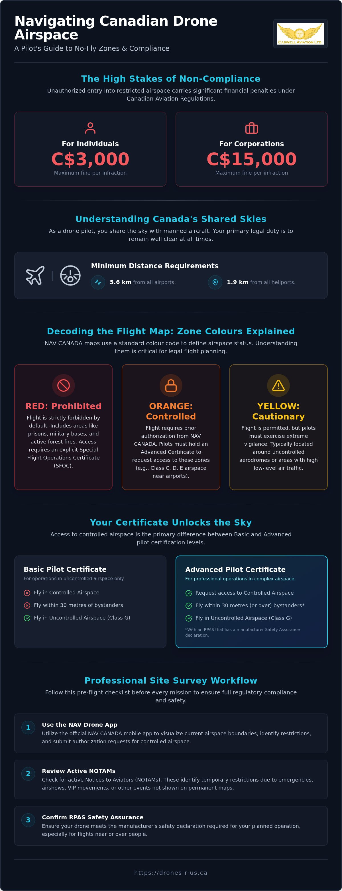
NAV CANADA acts as the country's civil air navigation service provider, while the National Research Council (NRC) maintains the digital infrastructure that visualizes these boundaries. Together, they manage the drone no-fly zones Canada requires to maintain aviation safety. Most restrictions are concentrated around airports, where drones must stay 5.6 kilometres away, and heliports, which require a 1.9-kilometre buffer. Ignoring these digital fences carries heavy consequences. Unauthorized entry into restricted zones can result in fines of up to C$3,000 for individuals and C$15,000 for corporations. In severe cases, safety risks can lead to even higher penalties or the immediate suspension of your pilot certificate.
The Legal Framework: CARs and Part IX
The Canadian Aviation Regulations (CARs) provide the statutory basis for all flight activity. Specifically, Part IX outlines the requirements for Canadian drone regulations. For drones weighing between 250g and 25kg, registration and certification are mandatory. Microdrones under 250g are exempt from registration but are still prohibited from entering restricted airspace without prior authorization. To operate near bystanders, you must ensure your RPAS meets the specific Safety Assurance requirements set by the manufacturer for that category of flight. These regulations ensure that every pilot understands the technical limitations of their equipment and the legal boundaries of the sky.
Why "No-Fly" Doesn’t Always Mean Never
The term "no-fly" is often a misnomer for professional operators. While some areas, such as Class F restricted zones or active forest fires, are absolute prohibitions, many others are simply "controlled." Access to these zones depends entirely on your pilot certificate level. Basic certificate holders are restricted to uncontrolled airspace, but Advanced pilots can request access to controlled zones through the NAV Drone app. This distinction is the primary reason why professional operators seek higher levels of certification.
Restrictions also vary by duration. Permanent zones cover airports and heliports, while temporary restrictions are issued via Notices to Aviators (NOTAMs) for events like emergency scenes or VIP travel. Professional training at a centre like Caswell Aviation Ltd prepares you to interpret these layers of data, ensuring you never inadvertently cross a legal line. Understanding the nuances of drone no-fly zones Canada allows you to move from being a hobbyist to a Master Practitioner who knows how to unlock the sky legally.
Decoding the Map: Understanding Red, Orange, and Yellow Zones
Visualizing drone no-fly zones Canada relies on a standardized colour-coded system that simplifies complex aviation data for the pilot. These digital layers are not mere suggestions; they represent the specific legal status of the sky at any given coordinate. Red Zones signify absolute prohibitions where flight is restricted by default. These include Class F restricted airspace, such as prisons or military installations, and active forest fire zones. Entering a Red Zone without an explicit Special Flight Operations Certificate (SFOC) or emergency authorization is a violation of federal law.
Orange Zones indicate controlled airspace, which is often the most misunderstood category. These areas are not closed to all pilots, but they require prior authorization from NAV CANADA. If you are operating in an Orange Zone, you must have an Advanced Pilot Certificate and a drone with a safety declaration for controlled airspace. Yellow Zones serve as cautionary boundaries. These are typically located around uncontrolled aerodromes or areas with high volumes of low-level manned traffic. While flight is permitted, the pilot must exercise extreme vigilance and maintain a proper lookout. Keeping current with Transport Canada drone flight rules is essential for interpreting these zones correctly.
Regulatory changes effective November 4, 2025, have introduced new complexities to these maps. Advanced certificate holders now have expanded privileges for Level 1 Complex Operations, which include sheltered operations and the use of medium drones weighing between 25 kg and 150 kg. These updates allow professional pilots to operate in areas that were previously restricted, provided they follow the updated safety protocols and notification requirements.
The NRC Drone Site Selection Tool (DSST-2)
The Drone Site Selection Tool (DSST-2) is the primary resource for pre-flight planning. Before arriving at a job site, you must use this tool to identify geographic flight boundaries. It's critical to select the correct "Operation Category" (Basic or Advanced) within the interface. A Basic pilot will see a map dominated by Red and Orange restrictions, whereas an Advanced pilot will see many of those Orange zones become accessible through authorization. You must also check for National Defence and Parks Canada boundaries, as these organizations enforce their own specific access requirements within the broader airspace framework.
NAV Drone: Real-Time Airspace Awareness
While the NRC tool is for planning, the NAV Drone app is for active authorization. It's the mechanism for realizing when a flight requires a digital "request for permission." For Advanced pilots, this app often provides near-instant authorization for flights in controlled Class C, D, or E airspace. Managing these digital requests while maintaining a visual line-of-sight on your aircraft requires efficient gear. Many professionals find that using a Fitek Gear drone harness allows them to manage their smart controller and airspace apps hands-free, ensuring they stay focused on the mission while staying compliant with all safety regulations.
Restricted vs. Controlled Airspace: Where Your Certificate Changes the Rules
Controlled airspace, comprising Classes C, D, and E, represents the most common hurdle for professional pilots. On your flight planning maps, these areas are typically designated as Orange zones. Basic certificate holders are largely excluded from these zones to ensure that only pilots with verified technical knowledge operate where manned traffic is most active. This regulatory barrier is designed to prevent conflicts in the busiest sectors of the Canadian sky.
Obtaining an Advanced certificate changes how you interact with drone no-fly zones Canada. This credential allows you to conduct Advanced Operations within controlled airspace, provided you have a drone with the appropriate safety declaration. It is the essential step for anyone moving from hobbyist flight to commercial service. For a step-by-step breakdown of the licensing process, refer to our Transport Canada drone certification guide.
Flying Near Airports and Heliports
Federal law establishes clear safety buffers around aviation hubs. You must not fly within 5.6 kilometres (3 nautical miles) of a certified airport or 1.9 kilometres (1 nautical mile) of a certified heliport. Advanced pilots can navigate these boundaries by securing a NAV CANADA flight authorization. This process often requires coordination with Air Traffic Control (ATC) to ensure your mission does not conflict with local flight patterns. A professional flight review is required to prove you can handle these complex environments safely and effectively.
National Parks and Emergency Sites
Airspace maps don't always reveal every restriction. National Parks are federally protected areas where drone flight is prohibited regardless of the airspace class. These are "hidden" no-fly zones that require special permits rarely granted for recreational use. You must also recognize the strict prohibition on flying near emergency perimeters. Whether it's a house fire or a police incident, drone interference can ground critical support like medevac helicopters. Realizing the difference between a municipal park bylaw and federal airspace law is a hallmark of a professional practitioner. While a city might restrict where you land, Transport Canada dictates where you can fly.
Professional Tools for Compliance: How to Conduct a Site Survey
A professional site survey is the bridge between digital planning and operational execution. While digital maps provide the foundation for identifying permanent drone no-fly zones Canada has established, they cannot account for the dynamic hazards present at a specific coordinate. A disciplined survey ensures you don't just fly legally, but also safely. It's the moment you realize that the digital representation of the sky must be reconciled with the physical reality of the ground.
- Step 1: Digital Map Verification. Access both the NRC Drone Site Selection Tool and the NAV Drone app to cross-reference permanent and temporary boundaries.
- Step 2: NOTAM Review. Check for time-sensitive restrictions that may have been issued since your initial planning phase.
- Step 3: Physical Perimeter Assessment. Walk the site to identify unmapped obstacles such as power lines, temporary structures, or localized GPS interference.
- Step 4: Meteorological Review. Confirm that current conditions meet Visual Flight Rules (VFR) minimums, including cloud clearance and visibility requirements.
Conducting these surveys requires you to manage multiple digital interfaces while staying mobile on uneven terrain. Professional pilots often utilize a drone harness for smart controller systems to maintain ergonomic comfort during lengthy site assessments. This gear allows you to keep your hands free for documentation or physical checks without losing access to your flight planning data. It's a pragmatic solution for pilots who value both precision and physical longevity.
Interpreting NOTAMs (Notice to Aviators)
A NOTAM is a critical alert issued by NAV CANADA to inform pilots of temporary changes to the national airspace. These notices can turn a previously "Green" open zone into a "Red" no-fly zone instantly due to VIP travel, emergency operations, or military exercises. You can find active NOTAMs through the NAV CANADA flight planning portal. To read the standard format, remember that the date and time are presented as a ten-digit string representing Year, Month, Day, Hour, and Minute in Coordinated Universal Time (UTC).
The Physical Site Survey Checklist
The physical survey is where you identify the local factors that maps often miss. Look for high-tension power lines, radio towers, or large metallic structures that might cause electromagnetic interference with your drone's compass or GPS. You must also assess the bystander factor. Determine if you can maintain the required safety distances from people not involved in the operation. Documenting these findings in your professional flight log is a requirement for maintaining your standing as a compliant operator in drone no-fly zones Canada. If you need assistance with Advanced flight planning or operational reviews, contact our training team for professional guidance.
From Restricted to Authorized: How Advanced Training Opens the Skies
Many pilots view the map and see drone no-fly zones Canada as impenetrable walls. However, for the professional practitioner, these boundaries are often just regulatory hurdles that can be cleared with the right credentials. Most "prohibited" areas on a standard map are actually controlled airspace that becomes accessible once you hold an Advanced Pilot Certificate. This transition from restricted to authorized is the primary goal of professional development in the RPAS sector.
Caswell Aviation provides the structured path necessary to achieve this status. Our online drone courses are designed to move beyond the basics, focusing on the technical and regulatory knowledge required for the Advanced exam. We also offer Level 1 Complex certification training, which is essential for pilots looking to operate medium drones or conduct sheltered operations under the latest 2026 regulations. This level of training doesn't just grant a piece of paper; it provides the operational confidence to manage high-stakes missions in proximity to manned aircraft.
The Path to Advanced Certification
Moving from Basic to Advanced status requires a deeper commitment to aviation theory. The Advanced exam is more rigorous than the Basic version, requiring an 80% score on 50 multiple-choice questions. While self-study is possible, in-person training often provides the nuanced understanding of airspace classes and weather patterns that digital modules might miss. The final step in this journey is the professional assessment. You can find detailed preparation tips in our guide to the drone flight review Canada process.
Equipping for Success in Complex Zones
Success in complex zones requires more than just knowledge; it requires the right tools. When you're operating in controlled airspace, the pressure to maintain precision is high. Professional-grade Fitek gear, such as ergonomic harnesses, is essential for these environments. These systems distribute the weight of your smart controller, reducing physical fatigue and allowing you to focus entirely on the flight path and airspace alerts. Ergonomic support translates directly into safer, more precise operations during long missions.
Don't let invisible boundaries limit your commercial potential. Organize your training today to stop avoiding drone no-fly zones Canada and start navigating them with professional authority.
Advancing Your Flight Operations: From Compliance to Access
Mastering the intricacies of drone no-fly zones Canada requires a combination of technical knowledge and professional discipline. You've learned that map boundaries are not just barriers; they are regulatory puzzles that can be solved through proper certification and active authorization. By implementing a rigorous site survey workflow and understanding the nuances of controlled airspace, you protect both your equipment and your professional reputation.
Caswell Aviation supports this transition with expert-led online and in-person courses tailored to the current aviation landscape. As Transport Canada authorized flight reviewers, we provide the necessary validation to move your operations into complex environments. We also serve as a specialized Fitek gear retailer to ensure you have the ergonomic support required for high-stakes missions. Unlock Restricted Airspace with Professional Drone Training and transform these digital boundaries into operational opportunities. Your journey toward becoming a master practitioner begins with the right preparation.
Frequently Asked Questions
Where can I find a map of drone no-fly zones in Canada?
You can access the official map data through the National Research Council’s Drone Site Selection Tool (DSST) for planning and the NAV Drone app for real-time awareness. These platforms visualize the drone no-fly zones Canada enforces to maintain aviation safety. While the NRC tool is best for preliminary site surveys, the NAV Drone app is the mandatory interface for requesting flight authorization in controlled zones.
Can I fly a drone in a Canadian National Park?
No, drone flight is strictly prohibited in all Canadian National Parks without a specific permit from Parks Canada. This regulation applies to all drone sizes, including microdrones under 250g. Permits are typically only granted for scientific research or specialized commercial projects, and recreational use is almost never authorized within these protected boundaries.
What happens if I accidentally fly my drone in a no-fly zone?
You face significant legal and financial penalties issued by Transport Canada for unauthorized entry into restricted airspace. For individuals, fines can reach up to C$3,000 per violation. Corporations may face penalties as high as C$15,000. Beyond the financial cost, an unauthorized flight can lead to the immediate suspension of your pilot certificate and potential criminal charges if manned aircraft safety is compromised.
Do I need permission to fly in a Yellow zone on the NRC map?
No formal authorization from NAV CANADA is required to fly in a Yellow zone, but you must exercise extreme vigilance. These areas indicate high-traffic environments or proximity to uncontrolled aerodromes where manned aircraft are likely to be operating at low altitudes. It’s your responsibility to remain well clear of all other aircraft and maintain a constant visual line-of-sight.
How do I request permission to fly in controlled airspace?
You must submit a digital flight authorization request through the NAV Drone app before entering any controlled Orange zone. This privilege is reserved for pilots who hold an Advanced Pilot Certificate and are operating drones with a manufacturer’s safety declaration. Many requests in Class C, D, and E airspace are approved automatically through the app's integrated system.
Are there drone no-fly zones near hospitals in Canada?
Yes, most hospitals feature certified heliports that are protected by a 1.9-kilometre (1 nautical mile) no-fly buffer. These zones are critical for ensuring that medevac helicopters can land and depart without interference. You must check your digital maps for these heliport boundaries, as they are often located in urban centres where drone activity is frequent.
How often are Canadian drone no-fly zones updated?
Permanent airspace boundaries are static, but temporary restrictions known as NOTAMs are updated in real-time throughout the day. Digital tools like the NAV Drone app reflect these changes immediately. It’s a professional requirement to check for new drone no-fly zones Canada might have issued for your area just before you begin your flight operations.
Can I fly a sub-250g drone in a restricted no-fly zone?
No, microdrones are prohibited from entering Class F restricted airspace and emergency perimeters. While drones under 250g are exempt from registration and pilot certification, they must still follow the rules of the sky. You cannot fly a microdrone near forest fires, police incidents, or military installations without explicit federal authorization.
Leave a comment