

Commercial Drone Photography in Calgary: A Professional Guide to Aerial Imagery
Hiring a drone operator for commercial drone photography without verifying their Advanced Pilot Certificate isn't just a minor oversight; it's a significant liability that puts your project and reputation at risk. Most aerial work in urban areas takes place within controlled airspace, where the margin for error is zero and Transport Canada's enforcement is strict. You likely recognise the immense value of aerial data for construction progress or high-end marketing, yet the confusion between Basic and Advanced operations often creates unnecessary hesitation.
We understand that you need high-resolution, professional imagery without the stress of regulatory non-compliance or equipment failure. This guide explains how professional drone photography delivers high-impact aerial data while adhering to every rigorous aviation standard. You will learn the technical requirements for urban flight, the benefits of specialised equipment like Fitek Gear harnesses for precision control, and how to ensure your next project is both visually stunning and fully legal.
- Understand the critical difference between Basic and Advanced drone operations.
- Learn about the regulatory requirements for safe and legal aerial projects.
- Discover how professional equipment enhances precision and data quality.
Key Takeaways
- Understand the legal requirement for an Advanced Pilot Certificate when conducting commercial drone photography Calgary within controlled urban centres.
- Evaluate the significant cost-to-value advantages of using RPAS platforms over manned aircraft for high-precision industrial and construction data collection.
- Learn the critical criteria for selecting a provider, including the verification of liability insurance and specialized flight review credentials.
- Discover how professional flight equipment and ergonomic harnesses contribute to the stability and precision required for marketing-ready aerial imagery.
- Recognize the transition from basic aerial photos to comprehensive data tools that enhance project management and safety standards on site.
The Evolution of Commercial Drone Photography in the Canadian Market
Commercial drone photography Calgary has transitioned from a niche novelty to a fundamental industrial tool. In the past, aerial views were the exclusive domain of high-budget productions using manned helicopters. Today, Remotely Piloted Aircraft Systems (RPAS) provide a more versatile, precise, and cost-effective alternative. This evolution isn't merely about the height of the camera; it's about the quality of the data collected. Modern aerial imagery serves as both a high-precision marketing asset and a critical data collection tool for complex projects.
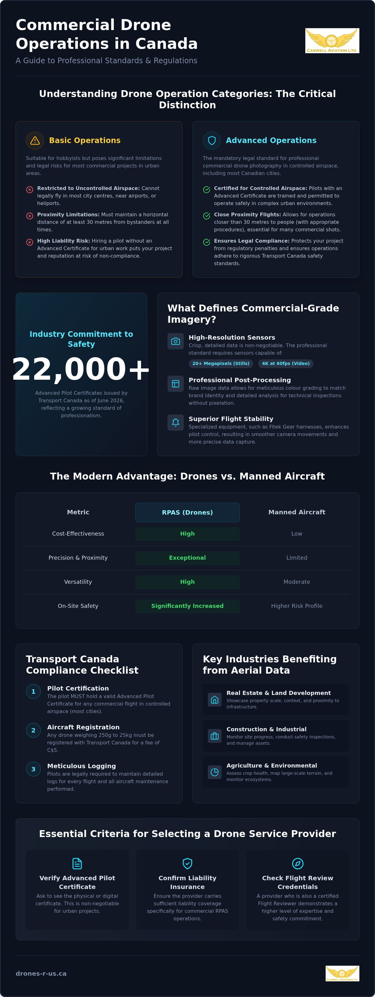
Professional standards in the Canadian market now demand high-resolution sensors. For imagery to be considered commercial-grade, it must be captured with sensors capable of 20 megapixels or higher for stills and 4K resolution at 60 frames per second for video. These specifications ensure that every frame contains usable information, whether it's for a cinematic marketing reel or a technical site inspection. As unmanned aerial vehicle regulations have matured, the industry has shifted toward a culture of technical mastery and safety. Transport Canada's framework now supports complex operations across the country, provided operators meet rigorous certification standards.
Why Professional Imagery Requires More Than Just a Drone
Hobbyist snapshots and commercial-grade deliverables are worlds apart. A professional result depends heavily on post-processing and colour grading to ensure the final product matches a brand's visual identity. Beyond aesthetics, the technical utility of raw data is vital for construction progress and infrastructure inspections. High-fidelity raw files allow project managers to examine minute structural details without the pixelation found in consumer-level equipment. Achieving this level of precision also requires flight stability, often enhanced by professional pilot gear like Fitek harnesses, which allow for smoother, more controlled camera movements.
Key Industries Benefiting from Aerial Perspectives
Several sectors investing in commercial drone photography Calgary are leveraging these advanced perspectives to gain a competitive edge. Real estate and land development firms use aerial views to showcase the true scale of a property and its proximity to local infrastructure. In the construction and industrial sectors, drones are used for routine site monitoring and safety inspections, providing a safer alternative to manual climbing. Agriculture and environmental sectors also utilize these tools for large-scale mapping and crop health assessments, turning aerial photos into actionable biological data.
Navigating Transport Canada Regulations for Professional RPAS Operations
Operating within the law is the first priority for any professional engagement. Under Part IX of the Canadian Aviation Regulations (CARs), Transport Canada divides drone operations into Basic and Advanced categories. For commercial drone photography Calgary, this distinction is critical. Basic operations are limited to uncontrolled airspace and must remain at least 30 metres from bystanders. However, because most of Calgary sits within controlled airspace or near populated areas, an Advanced Pilot Certificate is mandatory for nearly all commercial work in the city. As of June 2026, Transport Canada has issued over 22,000 Advanced Pilot Certificates, reflecting a growing industry commitment to these higher safety standards.
Compliance involves more than just holding a certificate. Every drone weighing between 250 grams and 25 kilograms must be registered with Transport Canada for a fee of C$5. Pilots are also required to maintain meticulous logs for every flight and all maintenance performed on the aircraft. These records are essential for demonstrating operational safety and are often requested during site audits or insurance reviews. For those looking to understand the full scope of these requirements, Transport Canada provides a comprehensive resource on flying your drone safely and legally.
Understanding Airspace Restrictions Across Canada
Professional pilots don't just take off; they coordinate. Accessing controlled airspace requires formal authorization from NAV CANADA through the RPAS Traffic Management platform. In high-risk environments, a Level 1 Complex certification may be necessary to ensure the highest safety margins. Hiring an uncertified pilot is a significant legal risk. If an accident occurs, the client may be held liable for property damage or personal injury because they failed to verify the operator's legal standing. We prioritize these protocols to ensure every project remains within the strict boundaries of Canadian aviation law.
The Role of Advanced Flight Reviews
A flight review is the final hurdle for an Advanced Pilot Certificate. During this in-person evaluation, a professional flight reviewer assesses the pilot's ability to manage emergencies, perform pre-flight checklists, and maintain situational awareness. Because Caswell Aviation functions as a national training provider for these reviews, our photography services are delivered by the same experts who certify the rest of the industry. This background ensures that our operational safety exceeds standard requirements. You can find more details in The Complete Guide to Transport Canada Drone Certification in 2026. If you need a partner who prioritizes these standards, consider our professional drone services for your next project.
Comparing Drones, Helicopters, and Fixed-Wing Aerial Platforms
Selecting the right platform for aerial imagery requires a clear understanding of project scale and site constraints. For many urban projects, commercial drone photography Calgary offers a superior cost-to-value ratio compared to traditional manned aircraft. Helicopters and fixed-wing planes involve high hourly operating costs, fuel surcharges, and complex logistics. In contrast, Remotely Piloted Aircraft Systems (RPAS) provide high-resolution results for a significantly lower investment, making them ideal for small to medium-scale commercial developments.
A primary technical advantage of drones is their ability to operate at low altitudes. Canadian aviation regulations generally require manned helicopters to maintain a minimum altitude of 1,000 feet over built-up areas. This height often results in a flat perspective that lacks the detail needed for marketing or inspections. Drones operate safely below 400 feet, allowing for dynamic angles that capture the texture and depth of a structure. Additionally, drones are electric and produce minimal noise, which is a significant benefit in residential areas or sensitive environmental zones where a helicopter's downdraft and roar would be disruptive. Businesses must also consider the responsibilities outlined by drone safety partners and manufacturers to ensure equipment is fit for the specific environment.
When Drones Outperform Traditional Aviation
Drones excel in scenarios requiring close-proximity data. They can perform cinematic fly-throughs and launch from confined spaces where a helicopter simply cannot go. For project managers seeking commercial drone photography Calgary, the ability to deploy a drone weekly for progress tracking is more practical than scheduling a manned flight. The rapid deployment of an RPAS allows for same-day adjustments based on weather or site conditions, providing a level of agility that traditional aviation can't match.
The Limitations of Modern RPAS
Despite their versatility, drones have specific constraints. Battery life remains a primary limitation, typically offering 20 to 40 minutes of flight time per set. This makes massive geographic surveys, such as mapping hundreds of kilometres of pipeline, more suited for fixed-wing manned aircraft. Calgary's climate also presents challenges; extreme cold and high winds can affect battery chemistry and flight stability. Finally, certain high-security no-fly zones or areas with heavy air traffic may still require the use of manned aircraft to ensure compliance with specific Nav Canada protocols.
Essential Criteria for Selecting a Commercial Drone Service Provider
Vetting a provider for commercial drone photography Calgary requires a structured approach that goes beyond reviewing a few portfolio images. You must first verify that the operator holds a valid Transport Canada Advanced Pilot Certificate. This certification is the only legal way to operate in the controlled airspace that covers much of the city. A professional provider will also maintain meticulous maintenance logs and flight records, which demonstrate a commitment to operational safety and equipment reliability.
Technical readiness is another critical factor. A seasoned operator doesn't show up with a single consumer-grade drone. They carry redundant systems, including backup aircraft, multiple sets of flight batteries, and high-speed data storage. They also use specialized equipment like Fitek harnesses to ensure the steady, ergonomic control required for precise flight paths. Review the provider’s portfolio for industry-specific experience; cinematic marketing requires a different skill set and sensor package than technical thermal imaging or 3D site mapping.
Insurance and Liability: Protecting Your Business
General business insurance policies almost always exclude "aviation activities," which leaves your company exposed if an accident occurs. You must confirm that your provider carries aviation-specific liability insurance. For industrial or high-density sites in Calgary, a C$5 million policy is the preferred standard, while C$1 million is the absolute minimum for lower-risk projects. While hull insurance covers physical damage to the aircraft itself, liability insurance protects against third-party property damage or bodily injury resulting from flight operations. Always request a certificate of insurance that lists your business as an additional insured party before the flight begins.
Deliverables and Turnaround Times
Defining the scope of the final product is essential for project planning. Determine if you need unprocessed RAW data for technical inspections or fully edited, colour-graded video for a marketing campaign. Most professional services use secure cloud platforms to streamline the project workflow, typically offering a turnaround time of 48 to 72 hours for standard deliverables. It's also vital to clarify ownership and licensing rights in your contract to ensure you can use the footage across all corporate platforms without future restrictions. If you need a partner who meets these high standards, you can book professional drone services that prioritize both quality and compliance.
Elevating Aerial Standards with Caswell Aviation’s National Solutions
Caswell Aviation Ltd functions as more than a service provider; it's a national centre for RPAS expertise. When you hire us for commercial drone photography Calgary, you're partnering with the same specialists who conduct Advanced and Level 1 Complex flight reviews for pilots across Canada. This dual role as both an educator and a practitioner ensures that our flight operations are governed by a culture of discipline rather than just a basic checklist. We bring a veteran’s perspective to every mission, ensuring that your project is executed with the highest degree of safety and technical precision.
Our approach is built on the belief that professional aerial work requires a combination of technical mastery and the right equipment. We don't simply provide a pilot; we provide a comprehensive aviation solution that includes regulatory coordination, high-resolution data capture, and post-processing. By choosing a team that sets the standards for the industry, you eliminate the uncertainty and liability associated with uncertified or inexperienced operators. Prioritizing compliance on your next commercial project is the only way to guarantee results that are both high-impact and legally sound.
Professional Training Meets Professional Execution
Our background in national pilot certification informs every photography mission we undertake. We don't just follow the rules; we understand the underlying aerodynamics and regulatory logic that keep your project safe and compliant. This deep understanding of the "why" behind aviation safety allows us to navigate complex urban environments with confidence. For a more detailed look at the standards we uphold, read What is a Drone Flight Review in Canada? A Professional Guide for 2026. Working with a team that trains the industry ensures that your project benefits from the most current safety protocols and flight techniques.
The Fitek Gear Advantage: Precision in Every Frame
Precision in aerial imagery isn't just about the camera sensor; it's about the pilot's physical control over the aircraft. We utilize and retail Fitek Gear harnesses for smart controllers because ergonomic support is essential for stable flight. These professional-grade harnesses redistribute the weight of the controller, reducing pilot fatigue during long industrial inspections or complex marketing shoots. This stability translates directly into smoother video pans and perfectly framed stills. You can learn more about these tools in our guide on Choosing the Best Drone Harness for Smart Controllers: A 2026 Professional Guide. Using the right gear allows our pilots to focus entirely on the creative and technical requirements of your mission.
Securing Your Competitive Edge with Professional Aerial Data
The transition to professional aerial imagery is a strategic investment in accuracy and safety. The legal landscape in Canada requires a deep understanding of Transport Canada's Advanced operations, especially within urban centres. Using a certified team isn't just about avoiding fines; it's about ensuring your project benefits from high-resolution sensors and stable flight paths. Caswell Aviation brings a culture of discipline to every mission, leveraging our status as Transport Canada Advanced Flight Reviewers and our expertise in Certified Level 1 Complex operations.
Precision matters when capturing data for industrial sites or marketing reels. We utilize Fitek Gear authorized professional equipment to maintain the ergonomic control necessary for steady, high-impact results. When you're ready to integrate commercial drone photography Calgary into your workflow, prioritize a partner who understands the regulatory technicalities as well as the creative ones. Book your professional aerial photography session with Caswell Aviation today and see your project from a new perspective.
Frequently Asked Questions
Do I need a special permit to hire a commercial drone photographer in Canada?
You don't need a personal permit to hire a professional, but the operator must hold a valid Pilot Certificate from Transport Canada. If the project is located in controlled airspace, the pilot must also obtain a flight authorization from NAV CANADA. A professional service provider manages these regulatory requirements on your behalf to ensure the mission is entirely legal.
What is the difference between a 'Basic' and 'Advanced' drone pilot?
A Basic Pilot Certificate is for operations in uncontrolled airspace at least 30 metres from bystanders. An Advanced Pilot Certificate is required for more complex missions, such as flying in controlled airspace or within 30 metres of people. Most commercial drone photography Calgary missions require an Advanced certificate due to the city's controlled airspace and urban density.
Can drones fly in controlled airspace near airports for photography?
Drones can operate near airports if the pilot holds an Advanced Pilot Certificate and receives specific authorization from NAV CANADA. This process involves submitting a flight plan through the RPAS Traffic Management platform. Professional operators coordinate with air traffic control to ensure the drone remains a safe distance from manned aircraft at all times.
How much does professional commercial drone photography typically cost?
Market rates for commercial drone services in Canada typically range from C$150 to C$400 per hour. For real estate, basic packages usually fall between C$150 and C$400, while more complex industrial or marketing projects can exceed C$2,000. These costs reflect the pilot's expertise, the quality of the sensor equipment, and the necessary insurance coverage for the site.
What happens if a drone crashes during a commercial shoot on my property?
A professional operator carries aviation-specific liability insurance to cover property damage or third-party injury. Standard general liability policies often exclude drone-related incidents, so it's vital to verify the pilot's specific coverage before the shoot. If a crash occurs, the insurance provider manages the claims process to protect both the pilot and the client from financial loss.
Can drones take photos inside a large commercial building or warehouse?
Drones are highly effective for indoor photography in large spaces like warehouses or industrial plants. Transport Canada's aviation regulations don't apply to indoor flight, meaning a certificate isn't legally required for these missions. However, indoor flight requires a high level of manual skill and specialized equipment, such as propeller guards, to navigate safely around structural obstacles and equipment.
How long does a typical drone photography session take to complete?
Most commercial sessions take between one and three hours to complete on-site. This timeframe includes the required pre-flight safety inspections, airspace checks, and multiple flight batteries to cover various angles. Larger industrial sites or construction projects requiring detailed mapping may take longer, depending on the total acreage and the specific data requirements of the client.
What kind of weather prevents a drone from flying for a scheduled shoot?
Flights are grounded by precipitation, high winds, or extreme temperatures. Most commercial drones shouldn't operate in rain or snow due to sensitive electronics, and winds exceeding 30 km/h can compromise flight stability. In Calgary, temperatures below -20°C also present a challenge, as extreme cold significantly reduces battery life and can impact the mechanical reliability of the aircraft's motors.
Leave a comment