

Canadian Construction Site Drone Monitoring Guide
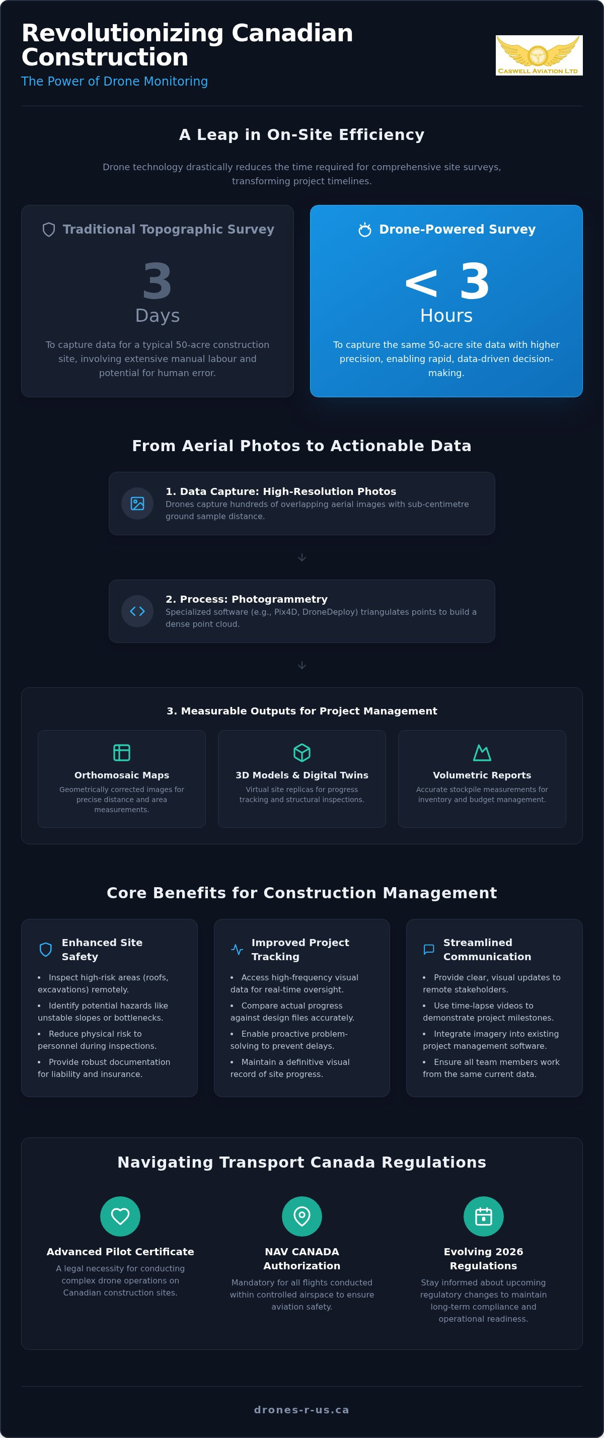
A traditional topographic survey of a 50-acre site can take up to three days to complete, yet a drone can capture that same data in under three hours. For project managers, the challenge isn't just about speed; it's about maintaining accuracy and safety in a high-stakes environment. You likely realize that manual stockpile tracking and ground-based inspections are becoming unsustainable for modern workflows. When you're managing Canadian construction site drone monitoring projects, the pressure to maintain strict Transport Canada compliance while avoiding project delays is constant.
We understand the physical fatigue and regulatory anxiety that often accompany high-precision aerial work. This guide will show you how professional drone monitoring enhances site safety, improves project tracking, and ensures you remain on the right side of evolving aviation laws. We'll preview the latest 3D modelling techniques, break down the upcoming 2026 regulatory changes, and explain how the right ergonomic equipment can streamline your entire data collection process.
Key Takeaways
- Learn how photogrammetry transforms standard aerial photos into measurable 3D models and accurate volumetric reports for precise material tracking.
- Understand the legal necessity of an Advanced Drone Pilot Certificate and NAV CANADA authorization when conducting site operations in controlled airspace.
- Discover how professional construction site drone monitoring Calgary workflows reduce project delays by providing high-frequency visual data for better site oversight.
- Identify how ergonomic field gear and specialized harnesses improve pilot focus and data quality during complex, multi-hour monitoring sessions.
- Evaluate the long-term ROI of training your internal team through professional flight reviews versus outsourcing your aerial imagery requirements.
The Role of Drone Monitoring in Canadian Construction Management
Construction site drone monitoring Calgary projects involves a systematic aerial oversight process that captures high-resolution data from perspectives ground teams cannot reach. This methodology has replaced traditional, manual inspections that often relied on sporadic site walks and subjective notes. By utilizing Remotely Piloted Aircraft Systems (RPAS), site managers now access high-frequency aerial data that provides a definitive record of site progress. This transition allows for a shift from reactive problem-solving to proactive project management.
The primary benefits of this technology include substantial cost savings and improved stakeholder transparency. Instead of waiting days for survey results, teams receive processed imagery within hours. This efficiency supports the creation of a digital twin, which is a precise virtual replica of the job site. This model allows for real-time project tracking and serves as a baseline for comparing actual progress against original design files. The various drone applications in construction demonstrate how these tools have moved from experimental gadgets to essential site equipment.
Improving Site Safety and Risk Mitigation
Safety remains the highest priority on any Canadian job site. Drones allow supervisors to inspect high-risk areas, such as roof structures or deep excavations, without putting personnel in physical danger. From a vertical vantage point, it's easier to identify potential hazards like unstable slopes, equipment bottlenecks, or improper material storage. Documenting these conditions through consistent flight logs provides a robust layer of liability protection and assists with insurance documentation. It's a pragmatic way to reduce the frequency of high-altitude site walks.
For reputable firms like Cardwell Property Services Inc., implementing such safety-first oversight is a key component of providing top-tier construction and property maintenance services.
Enhancing Stakeholder Communication
Effective communication keeps projects on schedule. Aerial imagery provides remote investors and project owners with clear, visual progress updates that ground-level photos cannot match. Using time-lapse aerial video helps demonstrate major project milestones during monthly reviews. Modern workflows allow for the seamless integration of this imagery into existing project management software. This ensures that every team member, whether they're in the field or the head office, is looking at the same current data. For firms looking to establish these capabilities internally, professional online drone courses and in-person training provide the necessary foundation for safe and compliant operations.
Technical Capabilities: From Orthomosaic Mapping to Volumetrics
While standard aerial photography captures visually appealing images for marketing purposes, technical data collection focuses on measurable precision. For construction site drone monitoring Calgary, the priority shifts from aesthetics to actionable information. High-resolution sensors allow pilots to capture data with sub-centimetre ground sample distance, ensuring that every pixel represents a specific, accurate coordinate on the earth's surface. An orthomosaic map is a geometrically corrected aerial image composed of stitched photos that provides a uniform scale across the entire construction site, allowing for direct measurements of distance and area.
This technical precision is made possible through photogrammetry. This process involves taking hundreds of overlapping images and using specialized software like Pix4D or DroneDeploy to triangulate points in three-dimensional space. The result is a dense point cloud that can be converted into a measurable 3D model. These models allow project managers to walk through a virtual job site to inspect structural details or verify utility placements without leaving the office. If your team requires high-precision data for an upcoming project, our drone aerial photography and video services provide the technical foundation needed for accurate site analysis.
Accurate Volumetric Analysis for Stockpile Management
Drones have transformed how firms manage inventory by providing precise volumetric measurements of gravel, soil, and mulch. Traditionally, estimating the volume of a stockpile involved manual measurements that were often inaccurate and time-consuming. According to 2026 industry data, a traditional topographic survey of a large site can take up to three days; however, a drone can complete the same task in roughly three hours. This speed allows for frequent inventory audits, ensuring that material volumes always align with project design specifications and budget forecasts.
Topographic Surveys and Site Plans
Generating contour maps and digital elevation models (DEMs) is essential for verifying site grading and drainage patterns. Drone data provides a comprehensive view of the terrain, identifying low spots or grading inconsistencies that could lead to water pooling or structural issues. These detailed site plans are often a requirement for development permit applications in various Canadian municipalities. By using drone-captured data, developers can provide officials with highly accurate, up-to-date visual evidence of site conditions, which often accelerates the approval process for complex builds.
Navigating Transport Canada Regulations for Site Operations
Conducting construction site drone monitoring Calgary projects requires more than just a capable aircraft; it demands strict adherence to Part IX of the Canadian Aviation Regulations (CARs). Because many urban job sites are located within controlled airspace, an Advanced Drone Pilot Certificate is a legal prerequisite for most commercial operations. Flying without this certification in restricted zones can lead to significant Transport Canada fines and increased liability for the project owner. It's essential to realize that the "Basic" category is generally insufficient for the complex environments found in Calgary's developing sectors.
Pilots must also coordinate with NAV CANADA to obtain flight authorization before entering controlled zones near airports or heliports. This process ensures that drone activities don't interfere with traditional manned aviation. Furthermore, the aircraft itself must be declared compliant by the manufacturer for the specific category of operation, such as flying near people. For professional site monitoring, the Advanced Certification is non-negotiable because it provides the only legal framework for operating in the high-density urban areas where most major construction occurs.
The Path to Advanced Certification
Achieving advanced status is a methodical process designed to ensure pilots possess the technical and theoretical knowledge required for safe flight. The following steps are mandatory for any professional wishing to operate on complex sites:
- Step 1: Complete an online drone course that covers essential aviation theory, meteorology, and Canadian flight regulations.
- Step 2: Pass the Transport Canada Advanced small RPAS exam with a minimum score of 80% to demonstrate theoretical proficiency.
- Step 3: Successfully complete a professional flight review with an authorized reviewer to validate your practical flight skills and safety procedures.
Maintaining Compliance and Recency
Holding a certificate is only the beginning of regulatory compliance. Transport Canada mandates a 24-month recency requirement. This means pilots must have completed a qualifying activity, such as a flight review or a specific training seminar, within the last two years to keep their certificate valid. Maintaining detailed, site-specific flight logs and maintenance records is also a requirement. These documents serve as proof of due diligence in the event of a site audit or an insurance claim. For a deeper look at these requirements, read The Complete Guide to Transport Canada Drone Certification in 2026.
Optimizing Pilot Performance: Ergonomics and Field Gear
Long-duration construction site drone monitoring Calgary operations often require pilots to remain on their feet for several hours while maintaining a constant line of sight. While the technical focus is usually on the aircraft, the physical demands on the pilot are significant. Heavy industrial smart controllers can weigh over 1 kg. Holding this weight without support leads to rapid fatigue in the neck, shoulders, and lower back. This physical strain isn't just a comfort issue; it directly impacts flight safety and the precision of the visual data being captured.
Fatigue reduces a pilot's reaction time and concentration. On an active job site where heavy machinery and personnel are constantly moving, a distracted pilot is a safety risk. Ergonomic field gear provides the stability needed to maintain smooth control inputs, which is essential for capturing the high-overlap imagery required for 3D modelling. When the controller is securely braced, the pilot can focus entirely on the flight path and data quality rather than managing the weight of the hardware.
The Benefits of Professional Drone Harnesses
A weight-distributing harness is the most effective tool for mitigating pilot exhaustion. By shifting the load from the hands and neck to the shoulders and torso, these systems allow for extended flight sessions without physical degradation. This stability also improves control precision. A stabilized controller prevents the micro-jitters often caused by tired muscles, ensuring smoother gimbal movements and more consistent flight lines. For a detailed comparison of available options, see our guide on Choosing the Best Drone Harness for Smart Controllers.
Fitek Gear for Smart Controllers
Fitek Gear has become the preferred choice for industrial pilots because it's designed for the rigours of the field. These harnesses feature quick-release clips that allow for rapid equipment changes and padded straps that remain comfortable throughout a full day of monitoring. Adjustable mounting points ensure the controller sits at the optimal height for the pilot's specific posture. Beyond ergonomics, a secure harness prevents accidental controller drops, which could otherwise result in costly equipment damage or a total loss of aircraft control on an active site. To improve your field efficiency and safety, consider upgrading to Fitek Gear Drone Harnesses for Smart Controllers for your next project.
Implementing Your Drone Strategy: Training vs. Outsourcing
Choosing between an internal team and an external provider is a pivotal decision for any firm engaged in construction site drone monitoring Calgary. Each model offers distinct advantages. Outsourcing allows you to leverage expert-level skills for high-stakes mapping without the overhead of hardware maintenance or insurance. Conversely, training your own staff enables daily data collection. This frequency is often more cost-effective for long-term project tracking and allows for immediate responses to site changes. The long-term ROI of an in-house program is significant for firms managing multiple concurrent builds.
Caswell Aviation Ltd supports both approaches. We provide the professional training required to certify your internal pilots and offer direct aerial imagery services for projects that demand specialized technical oversight. Whether you're looking to build a corporate drone department or need a one-time topographic survey, we ensure the data meets professional standards while remaining fully compliant with Canadian aviation laws.
Building an In-House Drone Program
Selecting the right personnel is the first step in creating a sustainable internal program. Ideal candidates are often those already familiar with site safety protocols and project management software. To maintain corporate compliance, these pilots must undergo standardized testing and practical evaluations. If you're wondering what is a drone flight review in Canada, it's the mandatory in-person assessment that confirms a pilot's ability to operate safely in complex environments. Standardizing this training across your team ensures a consistent level of safety and data quality.
Partnering for Professional Aerial Imagery
When a project involves complex 3D modelling or high-end marketing video, partnering with a specialist is often the most efficient route. It's vital to ensure any service provider you hire holds an Advanced Drone Pilot Certificate, especially for urban sites in Calgary. They should also demonstrate an ability to integrate their data directly into your existing BIM or project management workflows. Since these advanced integrations require robust technical support, visit ITS Canada Inc to see how their help desk services can support your firm's digital infrastructure. Use the following checklist when evaluating potential partners:
- Verify their Transport Canada Advanced certification and current pilot recency status.
- Confirm they carry adequate commercial drone liability insurance for construction environments.
- Review their portfolio for specific experience in volumetric analysis and photogrammetry.
- Ensure their data outputs are fully compatible with your internal project management software.
- Ask about their safety management system (SMS) and flight logging procedures.
Advancing Your Aerial Site Strategy
Implementing a robust aerial oversight program is no longer a luxury but a requirement for modern infrastructure projects. By combining precise technical data with strict regulatory adherence, you ensure that your site remains both productive and compliant. Effective construction site drone monitoring Calgary workflows depend on the triad of high-accuracy imagery, pilot-centric ergonomics, and verified certification.
Whether you're building an internal team or require specialized data for a complex build, professional support is essential. Caswell Aviation serves as a comprehensive resource, acting as a Transport Canada Authorized Flight Reviewer and a specialized Fitek Gear retailer. We provide the expert aerial imagery solutions and training needed to maintain high standards in a safety-critical industry. This methodical approach ensures your project data is accurate and your pilots are protected from the physical demands of long field sessions.
Take the next step in professionalizing your operations and book your Advanced Flight Review or drone training with Caswell Aviation today. We look forward to helping you realize the full potential of drone technology on your job site.
Frequently Asked Questions
What Transport Canada certificate is required for construction site drone monitoring?
To fly on most job sites, you'll need an Advanced Pilot Certificate. This is a legal requirement for construction site drone monitoring Calgary because these locations are usually in controlled airspace or near bystanders. A Basic Certificate doesn't permit flight within 30 metres of people or in restricted zones. Obtaining advanced status requires passing the Transport Canada small Advanced exam and successfully completing a practical flight review with an authorized reviewer.
How often should a construction site be monitored by drone for best results?
Weekly monitoring is generally recommended to provide a consistent record of project milestones. However, the frequency depends on the specific project phase. During rapid development stages like site grading or structural framing, daily flights might be necessary to provide stakeholders with real-time data. Consistent scheduling helps project managers identify potential delays before they impact the overall construction timeline and budget, ensuring the project stays on track.
Can drones accurately measure stockpile volumes on a job site?
Drones measure stockpile volumes with exceptional accuracy by using photogrammetry to generate dense 3D point clouds. This technology captures the entire geometry of a pile of gravel or soil, rather than relying on a few manual measurements. It's a reliable way to verify inventory levels and ensure material deliveries match the quantities billed by suppliers. This process significantly reduces the risk of costly discrepancies and inventory errors on the job site.
Do I need NAV CANADA permission to fly a drone on my site?
Permission from NAV CANADA is required whenever you operate in controlled airspace, which includes many urban job sites and locations near airports. Pilots must submit a flight authorization request through the NAV Drone platform before every mission. This step is a legal requirement under Canadian aviation law. It ensures that your drone activities are visible to air traffic controllers and don't pose a risk to manned aircraft flying in the area.
What are the benefits of using a Fitek Gear harness for site pilots?
A Fitek Gear harness provides essential ergonomic support by distributing the weight of a smart controller across the pilot's shoulders. This prevents the neck strain and physical fatigue that often occur during the long sessions required for construction site drone monitoring Calgary. Improved stability also allows for more precise control inputs. This leads to higher-quality data collection and ensures the pilot can remain focused on site safety throughout every flight session.
Is a flight review required for every drone pilot on a construction project?
Every pilot operating in the Advanced category must successfully complete an in-person flight review with a Transport Canada authorized reviewer. While this is a one-time assessment to earn the certificate, it's the only way to validate that a pilot can safely manage complex site operations. This process ensures that everyone flying on a project understands the necessary safety protocols and can effectively handle emergency situations in a high-stakes environment.
How does weather affect drone monitoring schedules in Canada?
Weather is a primary factor in Canadian flight operations because high winds, precipitation, and extreme cold can damage equipment or compromise safety. Most commercial drones are rated for specific temperature ranges and wind speeds. Pilots must often reschedule monitoring sessions to coincide with clear weather windows. This ensures the sensors can capture clear, unobstructed imagery and that the aircraft remains stable throughout the entire data collection process, avoiding data gaps.
What is the difference between a drone survey and standard aerial photography?
Standard aerial photography focuses on capturing visually appealing images for marketing or simple progress updates. A drone survey is a technical process that uses photogrammetry to generate measurable data like orthomosaic maps and 3D models. These outputs allow site managers to perform precise calculations for distance, area, and volume. While standard photos are useful for documentation, surveys provide the high-accuracy data needed for engineering and site planning on complex builds.
Leave a comment