

2026 Guide to Construction Drone Services in Alberta
By 2026, launching a drone over a Canadian job site without a Transport Canada Advanced certification isn't just a minor oversight; it's a significant liability that could halt your entire project. You've likely realized that manual site walkthroughs and traditional inspections often fail to keep pace with the scale of modern infrastructure. It's difficult to manage safety risks and progress tracking across large areas while trying to navigate the technicalities of federal aviation regulations.
This guide simplifies that transition. You'll discover how to leverage professional construction drone services from Caswell Aviation Ltd. to achieve precise 2D and 3D site mapping while ensuring your operations remain fully compliant. We'll outline the path to building a certified team, the importance of Advanced Flight Reviews, and how high-quality aerial imagery reduces site downtime. From regulatory requirements to the ergonomic gear needed for long operational days, this overview provides the practical roadmap your firm needs for a safer, more efficient job site.
Key Takeaways
- Learn how professional construction drone services Alberta utilize 2D orthomosaic mapping and 3D volumetric analysis to replace manual site walkthroughs with precision data.
- Navigate the complexities of Transport Canada regulations, including the specific requirements for Advanced and Level 1 Complex flight reviews on industrial sites.
- Identify how rapid aerial data acquisition reduces project downtime and mitigates the safety risks associated with traditional ground-based inspections.
- Discover the ergonomic gear solutions required to support pilot longevity and operational safety during the long flight hours typical of large-scale Alberta projects.
The Evolution of Construction Drone Services in Alberta
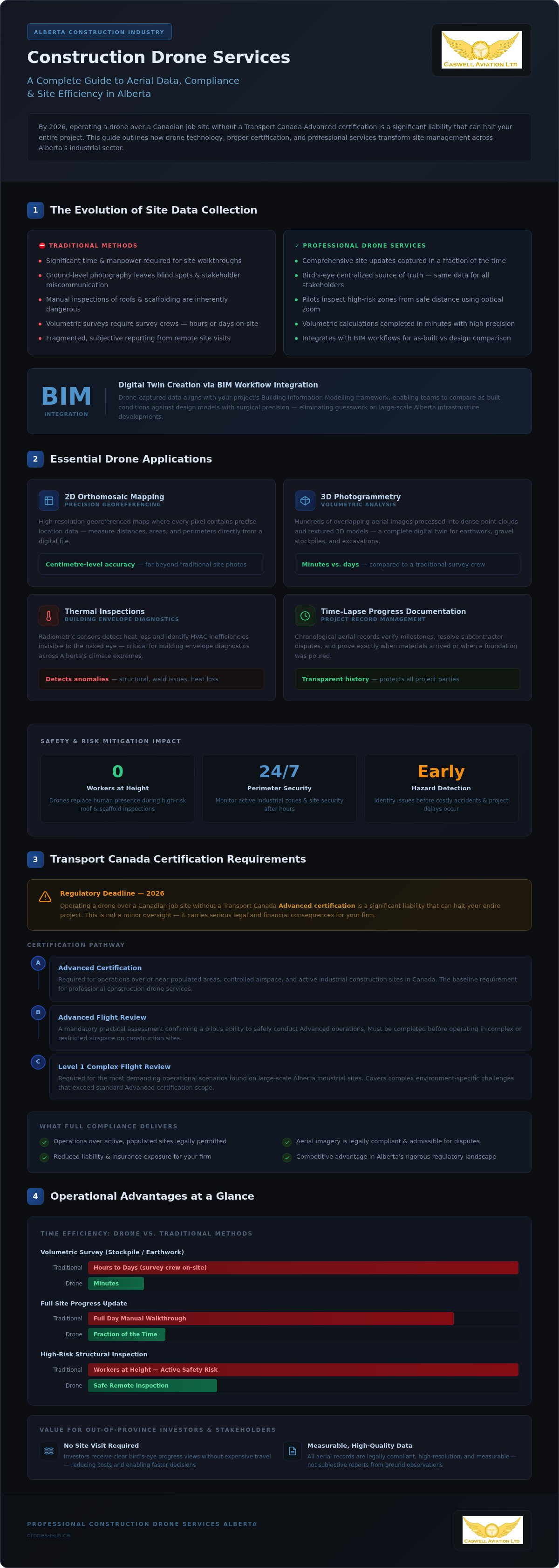
The Alberta construction landscape has seen a fundamental shift in how site data is collected. Traditional surveying methods, while accurate, often require significant time and manpower to navigate active, high-risk environments. Professional construction drone services Alberta provide a more efficient alternative. By transitioning to rapid aerial data acquisition, project managers now capture comprehensive site updates in a fraction of the time it takes for a manual walkthrough. This transition from ground-based observation to digital twin creation represents a significant leap in project management maturity for the province's industrial sector.
This isn't just about speed; it's about the quality of information. Integrating high-resolution aerial imagery into Building Information Modelling (BIM) workflows allows teams to compare as-built conditions against design models with surgical precision. When you align drone-captured data with your project's digital framework, you eliminate the guesswork that often plagues large-scale infrastructure developments. It's a methodical approach that prioritizes data density and accuracy over traditional, fragmented reporting.
Overcoming Traditional Site Visibility Challenges
Ground-level photography often fails to capture the full scope of a project, leaving stakeholders with blind spots that lead to miscommunication. Drones eliminate these gaps by providing a centralized source of truth. This transparency is particularly valuable for out-of-province investors who can't visit the site weekly. Instead of relying on subjective reports, they receive a clear, bird's-eye view of progress. Utilizing professional construction drone services Alberta ensures that these visual records are high-quality, measurable, and legally compliant. It reduces the need for expensive travel and ensures every decision-maker is looking at the same data.
Safety and Risk Mitigation Across Alberta Sites
Safety is the most compelling reason to adopt drone technology on active sites. Manual inspections of roofs, scaffolding, or high-elevation structural components are inherently dangerous. Drones remove the human element from these high-risk tasks. Pilots use high-resolution optical zoom to identify structural anomalies or weld issues from a safe distance. Beyond inspections, drones help monitor perimeter integrity and site security, ensuring that active industrial zones remain secure after hours. By identifying hazards early, firms prevent costly accidents and maintain a steady project timeline. This proactive stance on safety is essential for any modern construction firm looking to maintain a competitive edge in Alberta's rigorous regulatory environment.
Beyond aerial safety, it is equally important to ensure that ground-based heavy equipment operations meet the highest standards. For those looking to verify or upgrade their team's skills in other critical areas, you can check out A1 Crane Academy for specialized crane and utility worker certification programs that enhance overall site security.
Essential Drone Applications for Modern Site Management
Modern site management relies on data that is both visual and mathematical. When hiring construction drone services Alberta, project managers expect more than just high-quality photos; they require actionable datasets. 2D orthomosaic mapping creates high-resolution, georeferenced maps where every pixel contains precise location data. This allows teams to measure distances, areas, and perimeters directly from a digital file with centimetre-level accuracy. It's a significant improvement over traditional site photos that lack scale and context.
Achieving this degree of precision requires reliable GNSS corrections; for example, an RTK network subscription BC provides the high-precision VRS data necessary to ensure that aerial mapping remains accurate to the centimetre.
Beyond mapping, time-lapse progress documentation provides a chronological record of the entire build. This isn't merely for marketing. It serves as a vital project management tool for verifying milestones and resolving potential disputes with subcontractors. By maintaining a consistent aerial record, firms can prove exactly when specific materials arrived or when a foundation was poured. It creates a transparent history of the project that protects all parties involved.
Photogrammetry and Volumetric Measurement
Photogrammetry is the science of extracting reliable three-dimensional measurements from two-dimensional aerial photographs to ensure topographic accuracy in construction. By processing hundreds of overlapping images, software generates dense point clouds and textured 3D models that act as a digital twin of the site. This technology is particularly effective for volumetric analysis. Drones calculate the volume of earthwork, gravel stockpiles, or trenching excavations with high precision. This process takes minutes rather than the hours or days required for a survey crew to walk the piles. Frequent inventory checks become feasible, allowing for tighter budget control and better logistics planning.
Thermal Inspections and Building Envelopes
Thermal imaging adds another layer of diagnostic capability to your site inspections. Using radiometric sensors, drones detect heat loss and identify HVAC inefficiencies that are invisible to the naked eye. In Alberta's harsh climate, ensuring building envelope integrity is a priority. Drones locate moisture traps in flat roofing systems before they lead to structural rot or expensive internal damage. Having a detailed record of professional aerial imagery and video is essential when filing warranty claims or conducting final inspections. It provides the objective proof needed to hold vendors accountable for their work. These inspections are non-invasive and can be completed while site operations continue below, preventing unnecessary downtime.
Navigating Transport Canada Certification for Construction
Operating drones for construction drone services Alberta involves strict adherence to the Canadian Aviation Regulations (CARs). Transport Canada divides operations into Basic and Advanced categories based on the proximity to bystanders and the type of airspace. For most construction projects, especially those located near urban centres or industrial corridors, a Basic certificate is insufficient. The Advanced Drone Pilot Certificate is the standard requirement because it allows for operations within controlled airspace and closer to people, which is the reality of almost every active job site.
Large-scale industrial projects often involve Level 1 Complex operations. These missions require specialized knowledge and a higher degree of risk management. Understanding these requirements is essential for maintaining site safety and legal compliance. It ensures your operations don't interfere with manned aviation, particularly near Alberta's busy municipal airports or heliports. Choosing a partner who understands these nuances prevents the legal risks associated with unauthorized flights.
The Path to Your Advanced Pilot Certificate
Obtaining an Advanced certificate is a methodical two-step process. First, candidates must pass the Transport Canada Small Advanced Exam, which covers subjects like meteorology, air law, and flight theory. Once the exam is complete, the pilot must successfully pass an Advanced & Level 1 Complex Flight Review. This practical assessment verifies that the pilot can safely manage an aircraft in real-world conditions. Caswell Aviation acts as a veteran mentor throughout this process, providing the technical guidance needed to transition from a novice operator to a certified professional who can handle the pressures of an active site.
Compliance and Regulatory Peace of Mind
Certification is only the beginning of your regulatory responsibilities. To survive a site audit, you must maintain detailed logbooks and maintenance records for every aircraft in your fleet. Staying updated on drone regulations in Canada for 2026 ensures your team avoids costly fines or project shutdowns. Holding an Advanced status is non-negotiable for urban construction sites because it provides the legal framework to operate within the 30-metre safety buffer required for bystanders. This compliance provides peace of mind for both the contractor and the client, ensuring that aerial data collection remains a professional asset rather than a legal liability.
Optimizing Field Operations with Professional Gear
Professionalizing construction drone services Alberta requires more than just high-end aircraft; it demands gear that supports the pilot through long operational days. An 8-hour shift on a project site is physically demanding. Pilots often spend hours staring at screens while supporting the weight of a heavy smart controller. Relying on a standard neck strap is a common mistake that leads to significant fatigue. This strain doesn't just cause discomfort; it directly impacts flight precision and overall site safety.
Proper weight distribution is a technical requirement for operational longevity. When a pilot is fatigued, their reaction times slow and their control inputs become less fluid. By using professional mounting systems, the weight of the hardware is transferred away from the cervical spine. This allows the operator to maintain a high level of situational awareness without the distraction of physical pain. It's a methodical approach to safety that veteran practitioners never overlook.
Ergonomics for the Professional Pilot
Complex mapping missions require unwavering concentration and steady hands. A drone harness for smart controllers is essential for redistributing the weight of the hardware from the neck to the shoulders and torso. Fitek Gear has become the industry standard for this purpose. By using a multi-point harness system, pilots reduce the risk of long-term back and neck strain. This setup also allows for hands-free adjustments. If a pilot needs to check a site map or adjust PPE, they can do so without landing the aircraft or risking a dropped controller.
Field Durability and Controller Security
Construction sites are unforgiving environments. Dust, uneven terrain, and heavy machinery create constant hazards for sensitive electronics. A secure mounting system ensures that expensive smart controllers remain attached to the pilot at all times, preventing accidental drops. Consistency in control inputs is vital for capturing high-quality data for construction drone services Alberta. When the controller is held firmly against the body by a harness, the pilot's movements are more deliberate and stable.
Organizing your gear for rapid deployment is another key to efficiency. Alberta weather can shift quickly, requiring pilots to pack up or deploy in minutes. Using professional-grade harnesses and secure mounts allows for a more methodical workflow. If you want to improve your operational longevity and protect your investment, browse our professional drone harnesses and accessories.
Partnering with Caswell Aviation for Construction Excellence
Caswell Aviation Ltd occupies a unique position in the industry by operating as both a high-tier service provider and a dedicated educational centre. We don't just provide construction drone services Alberta; we mentor firms on how to professionalize their own aerial operations. This duality ensures that whether you choose to outsource your requirements or build an internal department, you're supported by veteran expertise. Our commitment to safety and Transport Canada compliance defines every project we undertake, providing a stable foundation for your site data needs.
For firms that prefer to focus on their core construction competencies, accessing high-quality aerial imagery services in Canada through our professional team is the most efficient path. We handle the complex flight planning, equipment maintenance, and necessary regulatory paperwork. Our pilots arrive on-site fully equipped and certified, allowing your project managers to receive actionable data without the overhead of managing a flight department. It's a pragmatic solution for projects that require immediate, high-resolution results.
Custom Training and Mentorship
Building an in-house drone team requires a structured approach to pilot development. Our customized training programs blend rigorous online theory with practical, in-person flight instruction tailored to the specific demands of a construction environment. We've seen numerous success stories regarding drone pilot jobs in Canada where our graduates have successfully integrated aerial data into their firm's daily operations. This mentorship extends far beyond initial certification. We provide ongoing support for complex flight planning and navigating the latest regulatory approvals, ensuring your team remains current with 2026 standards and Level 1 Complex requirements.
Getting Started with Your Aerial Program
Launching a successful aerial program begins with a methodical consultation and site assessment. We evaluate your project's specific needs, whether you require high-frequency mapping or specialized thermal inspections. During this initial phase, we also assist in selecting the appropriate Fitek Gear for your fleet. Ensuring your pilots have the right ergonomic support is a technical requirement for operational longevity and safety. By partnering with a veteran mentor, you avoid the common pitfalls of early-stage drone adoption and move straight to achieving measurable ROI. Contact Caswell Aviation Ltd to elevate your Alberta construction project today.
Future-Proofing Your Alberta Construction Site
The transition to digital site monitoring is no longer a luxury but a technical necessity for firms across the province. You've seen how professional mapping and volumetric analysis replace manual errors with centimetre-level precision. Integrating high-quality construction drone services Alberta ensures your project avoids the legal risks of unauthorized flights while maintaining strict Transport Canada compliance.
Caswell Aviation provides the specialized construction industry expertise required to navigate these complex requirements. As Transport Canada Authorized Flight Reviewers and the exclusive Fitek Gear retailer, we offer a comprehensive approach to both aerial data collection and pilot ergonomics. Whether you're outsourcing your imagery or training an in-house team, we act as your veteran mentor in the field.
Elevate your construction site with professional drone training and services from Caswell Aviation. Investing in these professional standards today prepares your site for the operational demands of tomorrow.
Frequently Asked Questions
How do I get a drone license for construction in Alberta?
You must pass the Transport Canada Small Advanced Exam and complete a practical flight review with an authorized provider. Most construction sites are in controlled airspace or near personnel, requiring the Advanced Pilot Certificate rather than Basic. Once you're certified, you must register your drone and keep your digital or physical certificate available during all operations. It's a methodical process that ensures safety on every job site.
What is the difference between Basic and Advanced drone certification in Canada?
Basic certification is for operations in uncontrolled airspace at least 30 metres from bystanders. Advanced certification allows you to fly in controlled airspace and within 30 metres of people, provided you use a compliant drone. Because construction sites often involve personnel and proximity to urban hubs, the Advanced certificate is the industry standard for professional projects. It provides the legal framework necessary for complex industrial environments.
Do I need a flight review to fly a drone on a construction site?
Yes, if your project requires an Advanced Pilot Certificate, a flight review is a mandatory step in the licensing process. An authorized reviewer must verify your ability to perform pre-flight checks, manage emergencies, and operate the aircraft safely. This practical assessment ensures that pilots provide construction drone services Alberta with the necessary technical discipline to work in high-stakes environments without compromising site safety.
What are the benefits of using a drone harness for smart controllers?
A professional harness redistributes the weight of the controller from your neck to your shoulders and torso. This prevents physical fatigue and long-term strain during multi-hour mapping missions. It also secures the controller against accidental drops and allows the pilot to maintain steady, precise control inputs. This ergonomic support is vital for capturing high-detail aerial data on active sites where concentration is a technical requirement.
Can drones be used for accurate stockpile volume calculations?
Drones use photogrammetry to create 3D models that provide highly accurate volumetric measurements. By capturing overlapping images of a stockpile, software calculates the volume of materials like gravel or earthwork with centimetre-level precision. This method is significantly faster than traditional ground-based surveying. It allows for more frequent inventory tracking without disrupting site operations, providing project managers with a reliable source of truth for logistics.
How long does it take to become an Advanced drone pilot in Canada?
The timeline depends on your study pace and flight review scheduling. Most professionals spend several weeks mastering the theory for the Small Advanced Exam. After passing the online test, you can typically book a flight review within a few days. Obtaining your certificate is a methodical process that ensures you're prepared for the regulatory and technical demands of industrial flight operations in the Alberta market.
What is a Level 1 Complex drone certification?
Level 1 Complex refers to specific operational approvals for missions that exceed standard Advanced limits. This often involves flying larger aircraft or operating in more restrictive environments. Authorized providers conduct these specialized flight reviews to ensure pilots meet the rigorous safety standards required for heavy industrial projects. It's a specialized qualification for unique infrastructure inspections where standard protocols aren't sufficient to manage the associated flight risks.
Is aerial thermography useful for construction progress tracking?
Aerial thermography is an essential tool for verifying building envelope integrity and HVAC efficiency. Radiometric sensors detect heat signatures that reveal moisture infiltration, insulation gaps, or structural anomalies invisible to the naked eye. While standard photography tracks visual progress, thermal data provides a technical layer of quality assurance. It's vital for warranty claims and final inspections, ensuring that construction drone services Alberta deliver comprehensive site intelligence.
Leave a comment