

Controlled Airspace Drone Photography in Calgary: A Professional Guide (2026)
What if your next high-value real estate shoot in the Calgary city centre resulted in a $15,000 corporate fine instead of a portfolio-defining shot? It's a sobering thought for any professional, yet the complexity of controlled airspace drone photography Calgary often makes compliance feel like a moving target. You likely recognize the frustration of trying to decode the difference between Transport Canada safety standards and NAV CANADA flight authorizations while on a tight production schedule. It's common to feel the weight of responsibility when operating near busy flight paths like those surrounding Calgary International Airport.
This guide provides the technical clarity you need to master these operations without legal liability. You'll learn how to obtain your Advanced Pilot Certificate, coordinate effectively with Air Traffic Control, and manage the physical demands of long days in the field. We'll walk through the specific 2026 regulatory requirements and the professional equipment strategies that ensure your operations remain both safe and profitable.
Key Takeaways
- Define the technical differences between Class C, D, and E airspace to identify where Advanced Operations are mandatory in urban centres.
- Identify the legal prerequisites for controlled airspace drone photography Calgary, including the transition from Basic to Advanced Pilot Certificates.
- Learn to utilize the NAV Drone app for both automated and manual ATC approvals to ensure seamless coordination with NAV CANADA.
- Explore how ergonomic tools like the Fitek Gear harness mitigate pilot fatigue and support safety-critical decision-making during long shoots.
- Understand why completing a professional flight review is the final essential step to securing your status as an Advanced RPAS pilot.
Navigating Controlled Airspace for Drone Photography in Calgary
Calgary's geography presents unique challenges for professional pilots. Most of the metropolitan area falls within the control zones of major airports and heliports, meaning that the majority of commercial work occurs within restricted boundaries. Successfully executing controlled airspace drone photography Calgary requires a transition from hobbyist habits into the disciplined framework of professional aviation. The Canadian model is built on a foundation of collaboration. Pilots must view Air Traffic Control (ATC) as a safety partner rather than a regulatory hurdle. This cooperative environment ensures that manned and unmanned aircraft share the sky without compromising public safety.
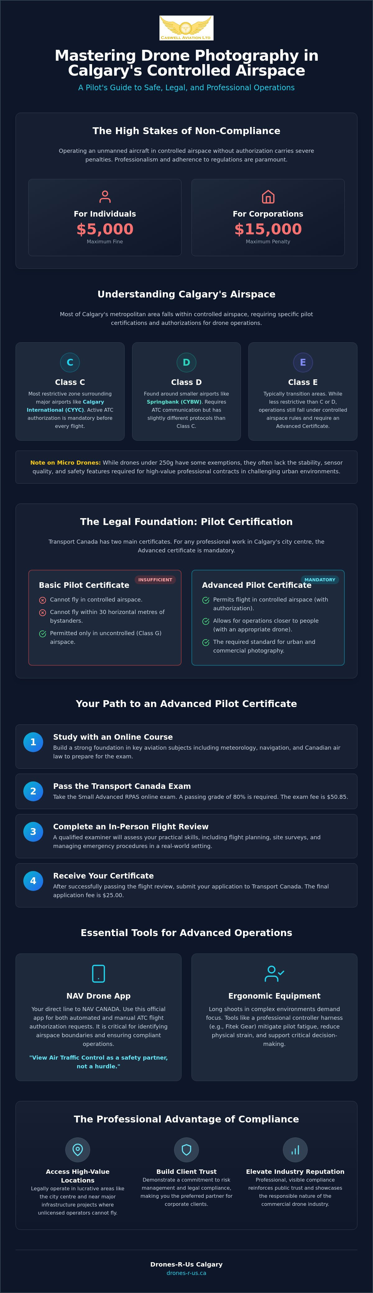
Operating in these zones without explicit NAV CANADA authorization in 2026 carries severe consequences. Transport Canada has established clear penalties for non-compliance. Individuals can face fines up to $5,000 for flying where not allowed, while corporations risk penalties as high as $15,000. Beyond the financial impact, unauthorized flights jeopardize the standing of the entire industry. Professional pilots maintain their reputation by adhering to the rules, ensuring that every flight is logged, authorized, and conducted within the limits of their certificate.
Understanding Airspace Classifications
Navigating Controlled Airspace involves identifying specific classifications that dictate your operational requirements. Class C airspace, which surrounds Calgary International Airport (CYYC), is the most restrictive and requires active authorization from ATC before take-off. Class D and E zones, often found around smaller airports like Springbank (CYBW) or as transition areas, have different communication requirements. You must use current RPAS tools and the NAV Drone app to identify these boundaries in real time. While micro drones under 250 grams offer a regulatory exception for some basic tasks, they often lack the sensor quality, wind stability, and safety redundancies required for high-tier commercial contracts.
Why Professional Photography Requires Controlled Access
The most lucrative photography opportunities typically exist where the airspace is busiest. High-value real estate in the city centre or major infrastructure projects often sit directly within controlled zones. Professional access to these areas allows you to capture perspectives that unlicensed operators cannot legally reach. This level of access is a major selling point for corporate clients who prioritize risk management and legal compliance. To see how these professional perspectives enhance property marketing even beyond local borders, you can discover Coulee Land Company and their approach to land sales. By demonstrating a mastery of the Advanced Operations framework, you position yourself as a reliable partner. Maintaining public trust through visible regulatory compliance is just as important as the quality of the final imagery. When bystanders see a pilot operating with the proper certifications and harnesses, it reinforces the professional nature of the industry.
Transport Canada Advanced Certification: The Legal Foundation
The legal framework for drone operations in Canada is divided into two distinct categories: Basic and Advanced. For anyone pursuing controlled airspace drone photography Calgary, the Basic certificate is insufficient. A Basic certificate only permits flight in uncontrolled airspace and requires pilots to stay at least 30 horizontal metres away from bystanders. In contrast, the Advanced certificate is the mandatory standard for urban environments and controlled zones. This certification allows you to operate within the controlled zones of airports and, depending on your drone's safety assurance, fly much closer to people.
The Path to an Advanced Pilot Certificate
Securing your credentials is a three-stage process that demands discipline and technical proficiency. First, you should invest in a high-quality online drone course to build a foundation in meteorology, navigation, and air law. Second, you must pass the Transport Canada Small Advanced RPAS exam. This online test costs $50.85 as of early 2026 and requires a passing grade of 80%. Finally, you must complete an in-person flight review with a qualified examiner. This practical assessment validates your ability to manage emergency procedures and flight planning in real-world conditions. Many pilots find that professional Advanced & Level 1 Complex Flight Reviews are the most efficient way to finalize this requirement. Once you pass your review, the final application fee to Transport Canada is $25.00.
Advanced Operations and Bystander Safety
One of the primary advantages of holding an Advanced certificate is the ability to operate in proximity to the public. To do this legally, your aircraft must have a manufacturer safety assurance declaration. This declaration confirms the drone meets specific safety standards for flying within 30 metres of bystanders or even over them. When you consult the Transport Canada Advanced Certification guidelines, you'll realize that safety is not just about the certificate; it's about the Pilot Operating Manual (POM). Advanced pilots must maintain a POM that outlines maintenance schedules and emergency protocols. This documentation is vital for managing risks in densely populated areas like the Calgary city centre. You must realize a safe flight path with precision to avoid unexpected hazards while ensuring your drone registration is current, which carries a $5.00 fee in 2026.
Strategic Planning: Coordinating with NAV CANADA and the NAV Drone App
Strategic planning is the bridge between legal certification and successful execution. For controlled airspace drone photography Calgary, this process centers on the NAV Drone app. This digital interface is the mandatory tool for all professional pilots seeking to enter controlled zones. Coordinating with NAV CANADA through the app ensures your flight plan is visible to other airspace users and air traffic controllers. It provides a real-time view of active NOTAMs and airspace restrictions that could impact your mission.
You must understand the two types of approvals within the system. Automated approvals occur instantly when your flight parameters fall within pre-defined safety grids. These are highly efficient for urban photography in less critical zones. However, manual approvals are required for more complex missions or areas closer to active runways. A manual review can take several business days; you should submit these requests well in advance of your scheduled shoot. If ATC needs to contact you during a flight, they will use the phone number linked to your NAV Drone profile. You must maintain a listening watch on your device and be prepared to land immediately if instructed by a controller.
The Step-by-Step NAV Drone Authorization Process
To submit a flight plan, you define your operational area on the interactive map and provide specific details regarding your aircraft and pilot credentials. You need to set a clear operational floor and ceiling height for your photography needs. For urban shots, this often means staying below the height of nearby structures while maintaining enough altitude for the desired perspective. The app will return a status of 'Approved' or 'Action Required'. An 'Action Required' status indicates that your plan conflicts with active restrictions or requires a manual review. Do not take off until you have received a definitive green 'Approved' notification.
Site Surveys and Risk Mitigation
A digital authorization does not replace the need for a thorough physical site survey. You must identify local hazards such as power lines, tall communication towers, and unmarked helipads at nearby hospitals. These obstacles often appear in the very urban centres where high-end photography is most requested. Your planning must include emergency procedures for lost-link scenarios. If your drone loses connection with the controller in a controlled zone, you must follow a pre-programmed return-to-home path that avoids active flight corridors. Documenting this entire planning process creates a reliable audit trail for Transport Canada. This discipline proves you are operating as a professional aviator rather than a casual user.
Ergonomics and Safety: Using Drone Harnesses in Complex Airspace
High-stakes operations in urban environments demand constant vigilance. When conducting controlled airspace drone photography Calgary, the physical toll on the pilot is often underestimated. Holding a heavy smart controller for several hours leads to muscle fatigue and neck strain. This physical discomfort directly impacts cognitive performance. In a complex aviation environment, a tired pilot is more likely to miss a radio call from ATC or overlook a telemetry warning. Professional aviation standards prioritize the health and comfort of the operator to ensure peak decision-making capability throughout the entire flight window.
Using a drone harness for smart controller is a practical safety intervention. It shifts the weight of the equipment from the pilot's hands and neck to the shoulders and torso. This redistribution of mass allows for greater stability and endurance during long-duration commercial photography shoots. Ergonomic gear is not a luxury; it's a foundational component of a professional safety management system. By mitigating fatigue, you maintain the mental clarity required to manage the technical and regulatory complexities of the Calgary city centre.
The Role of Ergonomics in Aviation Safety
Maintaining a constant Visual Line of Sight (VLOS) is a legal requirement that involves frequent head movements between the aircraft and the controller screen. A harness reduces the repetitive strain on the cervical spine by supporting the weight of the remote. By stabilizing the controller against the body, you also improve control precision. Small, subtle stick movements are easier to execute when the remote isn't wobbling in your grip. Professional pilots also value the ability to have hands-free moments. This allows you to check a physical site survey map or adjust your high-visibility vest without the risk of dropping expensive hardware.
Choosing the Right Fitek Gear for Your Controller
The Fitek Gear harness has become the professional standard for users of DJI Smart Controllers and other high-end RPAS remotes. It features multiple adjustability points to ensure a perfect fit for every pilot, regardless of their build. The design includes specific brackets that secure the controller firmly while keeping all ports and buttons accessible. Beyond comfort, a harness helps organize your field operations. It keeps the controller in a predictable, ready-to-use position, which is vital during complex shoots where timing and precision are everything. This stability is especially important when navigating the tight tolerances of urban flight paths.
Investing in the right support system ensures you can focus on the artistic and regulatory demands of the job without physical distraction. You can browse the full range of Fitek Gear drone harnesses to find the best fit for your specific controller setup.
Professional Flight Reviews and Training for Advanced Operations
Finalizing the certification process is the definitive step for any pilot serious about controlled airspace drone photography Calgary. While the online exam validates your theoretical knowledge, the flight review serves as the practical bridge to professional operations. It is the gold standard for urban pilots because it ensures you can translate regulatory requirements into safe, repeatable actions. Caswell Aviation Ltd provides the necessary ecosystem to move beyond basic proficiency, helping you develop the discipline required to deliver high-quality imagery in high-stakes environments.
A professional flight review is more than just a test; it is an opportunity to receive critical feedback from a veteran mentor. This process ensures that your operational habits align with the safety standards expected by both Transport Canada and your corporate clients. By booking Advanced & Level 1 Complex Flight Reviews, you complete the final requirement for your Advanced Pilot Certificate and gain the legal authority to operate in the most challenging zones of the city.
What to Expect During a Flight Review
The review begins with a thorough demonstration of your pre-flight checklists and site survey results. You must prove technical mastery of your RPAS by executing specific flight manoeuvres while maintaining full situational awareness of the surrounding airspace. Your reviewer will assess your ability to handle emergency procedures, such as a sudden loss of link or a low-battery return-to-home scenario. The session concludes with expert feedback that identifies strengths and areas for improvement, ensuring you leave with the confidence to manage complex urban shoots.
Customized Training for Corporate Teams
For construction firms and real estate agencies, scaling drone operations requires a standardized approach to training. In-person training options ensure that every member of your team understands the nuances of controlled airspace drone photography Calgary. This collective knowledge builds a culture of safety and professionalism within your organization, reducing the risk of legal liability or equipment damage. Customized sessions can be tailored to your specific industry needs, focusing on the technical requirements of infrastructure inspection or high-end architectural photography. This investment in team-wide compliance is essential for any business looking to lead the market in 2026.
The transition from a hobbyist to a professional pilot requires a commitment to continuous learning and rigorous standards. Elevate your operational capabilities by ensuring every flight is backed by the highest level of training and certification. You can finalize your journey into advanced operations by scheduling your review today.
Leading the Future of Urban RPAS Operations
Success in controlled airspace drone photography Calgary depends on viewing regulatory compliance as a competitive advantage rather than a hurdle. Throughout this guide, we've explored the necessity of advanced certification, the technicalities of NAV CANADA coordination, and the importance of physical ergonomics. Adopting these professional standards allows you to access high-value urban contracts that are off-limits to uncertified operators. As the Canadian drone market continues its projected growth into the late 2020s, maintaining these high-tier operational habits will define the industry leaders.
Caswell Aviation Ltd serves as your partner in this professional transition. With our team of Transport Canada Qualified Flight Reviewers and our status as a specialized Fitek Gear retailer, we provide the expertise and equipment required for Advanced and Level 1 Complex certification. We bridge the gap between technical training and real-world commercial success. Book your Advanced Flight Review or Drone Training with Caswell Aviation Ltd to ensure your operations meet the highest safety standards. Secure your place at the forefront of the industry by prioritizing precision and professional excellence today.
Frequently Asked Questions
Do I need a special licence for drone photography in Calgary?
Yes, you must hold an Advanced Pilot Certificate from Transport Canada to conduct controlled airspace drone photography Calgary. Most of the city is classified as controlled airspace due to the proximity of the Calgary International Airport and various hospital heliports. Operating a drone between 250 grams and 25 kilograms in these zones without an Advanced certificate is a violation of federal aviation regulations.
How do I get permission to fly in controlled airspace in Canada?
You must obtain authorization from NAV CANADA by submitting a flight plan through the NAV Drone app. The system provides automated approvals for many urban areas if your flight parameters meet pre-set safety criteria. For missions closer to active runways or in more sensitive zones, a manual review by air traffic controllers is required. You cannot take off until you receive a green "Approved" notification within the app.
Can I fly a mini drone in controlled airspace without an Advanced Certificate?
Micro drones weighing less than 250 grams do not require an Advanced Pilot Certificate or NAV CANADA authorization to operate in controlled airspace. However, you must still fly in a way that does not jeopardize aviation safety or people on the ground. While legal, these small aircraft often lack the wind resistance and camera sensors required for high-tier professional photography contracts in the Calgary city centre.
What happens if I fly in controlled airspace without NAV CANADA approval?
Flying in restricted zones without proper authorization leads to heavy financial penalties and potential legal action. Transport Canada can issue fines up to $5,000 for individuals and $15,000 for corporations for flying where not allowed. Beyond these fines, unauthorized flights can lead to the suspension of your pilot certificate and significant liability if an incident occurs with manned aircraft.
How long does it take to get Advanced drone certification?
The timeline for certification depends on your preparation for the Advanced Small RPAS Exam and the availability of a flight reviewer. Once you pass the online exam, which has a $50.85 fee, you can immediately schedule your in-person flight review. After successfully completing the review, you apply for the certificate through the Transport Canada portal for a $25.00 fee. The digital certificate is typically issued shortly after the application is processed.
Is the NAV Drone app free to use for professional pilots?
The NAV Drone app is free to download and use for both professional and basic pilots in Canada. It serves as the primary tool for flight planning and provides essential situational awareness regarding NOTAMs and airspace boundaries. Regular updates, such as the May 2026 release, have improved visualization tools to help pilots identify complex multi-RPAS activity zones more effectively.
What is a Level 1 Complex flight review?
A Level 1 Complex flight review is a specialized practical assessment for pilots who intend to operate in challenging environments, such as densely populated urban areas. It validates your ability to manage advanced equipment and emergency procedures under the scrutiny of a qualified reviewer. This review is a mandatory step for any pilot wanting to move beyond basic operations and secure their Advanced Pilot Certificate.
Why should I use a drone harness for professional photography?
A drone harness is a critical safety tool that redistributes the weight of a smart controller to your torso and shoulders. This reduces neck strain and muscle fatigue during long-duration commercial shoots. By stabilizing the controller, you improve your stick precision and maintain the mental clarity needed for safe decision-making in high-pressure environments. Professional pilots use ergonomic gear like Fitek Gear to ensure they remain focused on the aircraft and the surrounding airspace.
Leave a comment