

Commercial Property Drone Photography: A Practical Buyer’s Guide
People searching for commercial property drone photography may be looking for a clear way to document a site, explain its layout or prepare marketing visuals. The most useful image depends on the task: a wide photograph can show how buildings and outdoor areas relate, while a short video can guide viewers through the property.
Striking visuals are useful, but appearance alone doesn’t define a successful project. Consider what the images need to communicate, how the site will be coordinated, and which permissions and safety requirements apply. Aerial photographs and video can support communication and documentation, but they aren’t a substitute for specialist inspection.
This guide explains how to match aerial imagery to a property-management need, compare photo and video deliverables, and prepare a clear project brief. You’ll find practical details to outline before a flight, including the areas to capture, intended audience and planned use of the content. Caswell Aviation Ltd creates aerial photography and video tailored to client requirements, with the project shaped around the visual information you need.
Key Takeaways
- Start with the property decision or communication need, then choose aerial views that support it rather than commissioning imagery for appearance alone.
- Compare still photographs, video and specialist mapped outputs by what each can communicate and how stakeholders will use them.
- Aerial imagery can show a site’s layout and surroundings, but it doesn’t replace technical verification or specialist inspection.
- Build a practical project brief around the areas to capture, site access, active operations, people and stakeholder coordination.
- Align deliverables with their intended use. Caswell Aviation Ltd tailors aerial photography and video to client requirements.
Commercial Property Drone Photography: Start With the Property Decision
A striking aerial view can attract attention, but attention alone may not answer a property question. Start by identifying what the imagery needs to help someone understand, discuss or decide. A site overview may need to show how buildings, access routes and outdoor areas relate. A progress update may need to make visible changes easy to compare. Marketing material may call for a different viewpoint and pace than an internal property record.
Commercial property drone photography is the creation of aerial photographs or video of a commercial site to communicate its layout, visible features, progress or setting. Let that purpose guide the brief. Define the intended audience and use before deciding what to capture.
Think of the brief as a practical set of instructions, not simply a request for attractive views. Identify the areas of interest, preferred viewpoints, timing, image format and level of detail. A broad view may explain how a site is organized; closer framing may draw attention to a particular visible feature. Choose views according to the message, rather than relying on a default shot list. A general drone photography overview describes the medium, while a property brief translates it into a specific communication task.
- Site overview: Show how buildings, parking areas and outdoor spaces are arranged in relation to one another.
- Progress communication: Help stakeholders compare visible changes between planned updates.
- Asset context: Present a feature within its wider site setting, without implying technical assessment.
- Marketing material: Give prospective tenants, buyers or partners a clearer sense of the property and its surroundings.
Which property-management tasks benefit from aerial imagery?
A broad site view can make spatial relationships easier to discuss than a collection of ground-level images alone. For example, a property manager could include an aerial image in a stakeholder update to show a building’s position relative to access areas, or keep a dated visual record in property files. The imagery may also provide useful context for marketing discussions. It documents what is visible; it doesn’t verify condition or replace a specialist assessment. For wider commercial marketing campaigns, drone footage is frequently paired with professional business imagery from studios like The Photography Co to present a comprehensive portfolio.
When should aerial photography be considered?
Consider whether the site is difficult to communicate clearly from ground level, whether key features are visible from the air, and whether the audience needs a whole-site perspective. Scale matters too: an aerial view may help explain a large or spread-out property, while ground photographs or existing records may adequately show a small, straightforward area.
For a one-time record, define the event or date the imagery should represent. For recurring updates, plan a consistent purpose and comparable viewpoints so viewers can follow visible change over time. A drone isn’t necessary for every property task. Choose it when the aerial perspective adds information the audience can use, and keep the brief focused on that need.
Choose Drone Photography Deliverables That Match the Brief
Use this comparison to match the deliverable to the task:
| Format | Communication purpose | Review workflow | Limitations |
|---|---|---|---|
| Still photographs | Show a site, feature or viewpoint as a fixed reference for records, presentations or stakeholder discussions. | Review individual images, select relevant views and compare dated images when the viewpoints are consistent. | A photograph captures a moment and viewpoint; it doesn’t show movement or verify hidden conditions. |
| Video | Guide viewers through a property or show how visible areas relate within a broader site context. | Review the sequence as a whole. Check whether the order and pacing make the intended points clear. | Details can pass quickly, and viewers may need a still image or another record for closer reference. |
| Specialist mapped outputs | Support specific technical uses that require defined mapped or measurement information. | Review against the stated technical requirements, intended use and required accuracy. | These outputs involve specialist methods and expectations. Standard aerial photography doesn’t automatically provide them. |
Aerial photographs versus drone video
Choose stills when people need to pause on a clear viewpoint, identify visible features or place images in a report. Choose video when a guided sequence can explain the site more effectively, such as by showing how different areas connect. A planned corporate drone video can suit a presentation or marketing discussion. Caswell Aviation Ltd tailors aerial photography and video to client requirements.
When does a project need technical mapping?
Photogrammetry uses overlapping photographs to create outputs such as an orthomosaic, a composite aerial image assembled from multiple photos. These outputs differ from ordinary photographs and carry different technical expectations. Before specifying them, define the required accuracy and intended use. Visual context can help people understand a site, but it isn’t the same as measured, survey-grade or engineering information.
Don’t assume a standard aerial photography brief includes measurement or mapping. If a decision depends on dimensions, positional accuracy or technical verification, name that requirement clearly and distinguish it from visual communication. For marketing, general records or a stakeholder update, stills or video may be the more direct fit. A well-scoped request keeps the deliverable aligned with what reviewers need to see.
Assess Project Fit: Value, Limitations and Alternatives
Aerial imagery is useful when its viewpoint makes a property easier to understand. It may help stakeholders see how visible areas relate, but it can’t answer every operational question. Imagery supports decisions only when its perspective and limitations fit the task. Before commissioning a visual record, consider whether ground-level photographs or existing site documents could meet the same need.
- Aerial views: Provide broad site context and make the arrangement of visible features easier to communicate. They may offer limited detail for close review and don’t reveal hidden conditions.
- Ground-level photographs: Show selected areas from a person’s viewpoint and can provide closer visual detail. They may not convey how separate areas relate across a larger site.
- Existing site records: Provide established information for reference and comparison. Their usefulness depends on their age, coverage and relevance to the current question.
What drone photography can show, and what it cannot prove
Drone photographs can show visible features and spatial relationships from an elevated perspective. They don’t establish structural condition, regulatory compliance or measured accuracy. A clear image of a roof, for example, is still a visual record, not a technical finding. If a decision requires inspection, surveying or engineering information, treat that as a separate scope with the appropriate specialist.
A compelling aerial view can support a discussion, but it shouldn’t be presented as evidence of something the image cannot determine.
A simple framework for comparing options
Compare each option against five practical factors: viewpoint, coverage, context, update needs and intended audience. Then choose the simplest format that gives the audience enough information for the communication task. Use the table as a starting point, alongside a clear description of what the images or records need to help people understand.
| Option | Viewpoint and coverage | Context and detail | Updates and audience |
|---|---|---|---|
| Drone imagery | Elevated view; can show visible areas across a site. | Useful for broad spatial context; limited for close or hidden conditions. | Can support repeat visual updates with planned, comparable views; suits stakeholders who need an overview. |
| Ground-level photos | Person-level view; usually covers selected locations. | Can show closer detail; may provide less overall site context. | Practical for documenting specific visible areas; suits viewers focused on those locations. |
| Existing records | Coverage and perspective depend on the source material. | May provide plans, notes or previous visual context; check whether they address the current question. | Useful for reference or comparison; suits reviewers already working with those records. |
For a broad update, an aerial view may add context. For a close look at a specific visible feature, a ground photograph may be more direct. For formal technical conclusions, neither image type nor an old record should be treated as a substitute for the relevant specialist work.
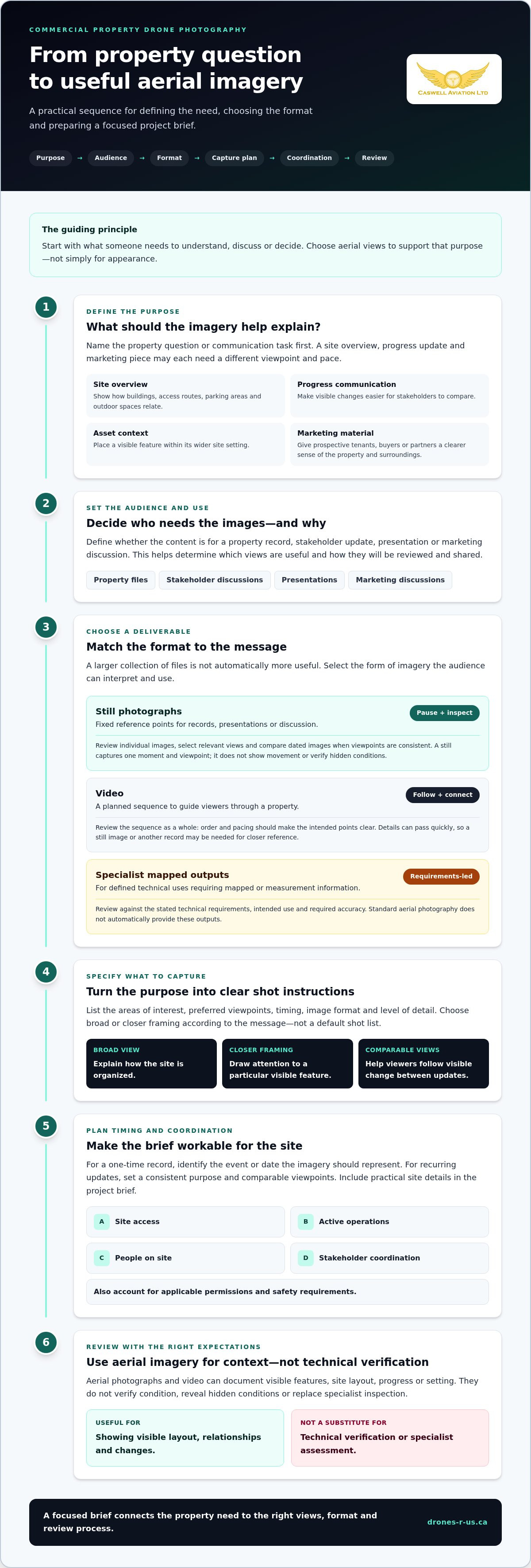
Plan a Commercial Property Drone Photography Project
A clear project plan connects the property’s communication need to the flight, site schedule and final review. Define what the imagery needs to show before arranging access or selecting viewpoints. A focused brief helps keep the work relevant and gives everyone involved a shared understanding of the assignment.
Build a useful photography brief
Set out the purpose, audience and intended use first. Name the property areas to capture, preferred viewpoints and whether you need still photographs, video or both. Separate essential coverage from optional views so the assignment stays focused if time or site activity changes. If you have a reference plan or existing images, identify them as context, not as a substitute for explaining the current visual need.
- Define the objective. State what viewers should understand after seeing the images, such as the overall site arrangement or visible progress.
- List priority areas. Identify the buildings, outdoor spaces or access points that matter most. Mark optional coverage separately.
- Specify the audience and use. Note whether the visuals are for internal records, stakeholder communication, a presentation or marketing discussions. This affects which views will be most useful.
- Choose the format. Indicate whether still photographs, video or a combination best supports the purpose. Describe any preferences without assuming a particular delivery specification.
- Coordinate the site. Identify the site contact, access process, active operations, people who may be present and any sensitive areas or privacy considerations.
- Review the result. Compare the delivered visuals with the brief. Check that priority areas are represented and that the images suit their intended audience and use.
Coordinate safety, access and timing
Site conditions shape the flight plan. Coordinate access controls and operating activity with the property contact, and consider whether people, vehicles or sensitive areas affect where and when imagery can be captured. Weather can also influence whether a planned viewpoint or timing is suitable. Check current Transport Canada guidance and applicable site requirements as part of planning, since one arrangement won’t fit every property.
Give stakeholders a clear point of coordination and communicate the planned areas and timing to those whose work could be affected. If operations change or access is restricted, the plan may need to adapt. Make priorities clear in the brief so essential coverage remains distinct from optional views.
Caswell Aviation Ltd tailors aerial photography and video to client requirements, guided by the property’s intended use. To shape a brief around your site and communication goals, discuss your aerial imagery requirements.
Engage a Drone Photography Service With a Clear Scope
A clear scope turns a property need into useful aerial photographs or video. Instead of requesting broad coverage, describe what the visuals should help people understand and how they’ll be used. This gives the project a practical focus, whether the goal is to support a management discussion, prepare presentation material or maintain a visual record.
Caswell Aviation Ltd provides professional aerial photography and video tailored to client requirements. Define the purpose, audience and key views so the imagery suits the brief. Photography and video can show visible features and site context, but they aren’t a substitute for specialist inspection, surveying or technical verification.
What to include when requesting a project discussion
Prepare a concise summary of the property and the outcome you want the visuals to support. Identify who will review them, the intended use and any timing considerations, such as a planned presentation or property update. Note whether still imagery, video or both best fit the task. A short priority list helps distinguish must-have coverage from optional views without prescribing unnecessary detail.
- Property and priorities: Describe the site and identify the areas or visible features that matter most.
- Purpose and audience: Explain what viewers should understand and who will use the material.
- Timing: Share relevant dates or site activity that could affect when the imagery is most useful.
- Format: State whether photographs, video or a combination better supports the intended use.
- Coordination: Flag access arrangements, privacy considerations, active operations, sensitive areas and stakeholders who should be informed.
These details align the aerial content with the property’s communication need and surface practical considerations early. Keep technical requirements distinct from visual requests. If a decision needs measured or specialist findings, those require a separate scope.
Turn imagery into a repeatable property record
For recurring updates, consider which viewpoints will remain useful over time. Consistent angles can make visual comparisons easier, while recording capture dates and relevant context helps viewers interpret what they’re seeing. Note the purpose of each set, such as a progress update or general site record, so later reviewers don’t mistake a visual comparison for a technical assessment.
Before sharing the final selection, compare it with the original objective. Keep the images that answer the intended question and choose video where a sequence communicates the site more clearly. A focused set is often easier for stakeholders to review than coverage without a defined use.
To discuss how professional aerial photography or video can be tailored to your property’s intended use, Discuss your commercial property imagery brief.
Make Your Next Property Brief Count
Before commissioning imagery, write down the decision or conversation you want it to support. That prompt helps keep the project focused on a useful outcome, rather than producing visuals without a clear role. Consider who will review the material, where it will be used and how you’ll retain it for future reference.
After delivery, keep the date and purpose with the selected files, and share them with the people involved in the intended decision. This preserves context and can make future property discussions more organized. If the project’s needs change, a new brief can set a different purpose and guide the next set of visuals.
Caswell Aviation Ltd creates professional aerial photography and video tailored to client requirements for clients across Canada. Start with the property question you need to communicate, then discuss your commercial property imagery brief.
Frequently Asked Questions
Can drone photography help with commercial property management?
Yes. Aerial photographs can give managers a shared visual reference when discussing changes to outdoor areas, such as reorganized parking or updated storage zones. They can also help explain site circulation to stakeholders who aren’t familiar with the property. Use the images to support planning conversations and keep the relevant date with them. For decisions involving safety, condition or compliance, use the appropriate specialist assessment.
What is the difference between drone photography and drone surveying?
Drone photography creates visual content for communication, while surveying aims to produce information for defined measurement or spatial tasks. Surveying may require specified methods, accuracy expectations and control data that an ordinary photo assignment doesn’t provide. If a project depends on dimensions or mapped positions, describe that requirement separately from a request for pictures. The intended use determines whether visual imagery is enough or a surveying scope is needed.
Can aerial photographs show roof or building damage?
Aerial photographs may show visible signs such as displaced materials, debris or standing water if they’re visible from the camera’s position and captured clearly. They can’t establish the cause, extent or severity of a problem, and a view from above may miss details hidden by roof features or the viewing angle. Treat an image as a prompt for closer review, not a diagnosis. Have a qualified building or roofing specialist assess suspected damage.
How often should a commercial property be photographed from above?
There’s no single schedule that suits every property. Set the timing around the reason for the record: a change to site layout, a major project milestone or a management review may prompt new imagery. If comparisons matter, use a repeatable interval that fits the decision cycle and retain earlier files for reference. Avoid commissioning repeat flights without a clear question the new images are meant to help answer.
Is drone photography suitable for occupied or active commercial sites?
It may be suitable, but the plan should account for people, vehicles, deliveries and work areas. A property contact can identify busy periods, restricted access points and areas where staff or visitors may be present. Scheduling around high-activity times and communicating the plan to relevant stakeholders can reduce disruption. Privacy considerations and applicable operating requirements also need attention; site activity and conditions influence whether and how imagery can be captured.
What should I include in a commercial property drone photography brief?
Include the property overview, communication goal, intended audience, preferred timing and whether you need photographs, video or both. List priority areas, any views to avoid, relevant access or privacy considerations, and a stakeholder who can coordinate site details. State how the finished visuals will be used.
Leave a comment