

How to Calibrate a Drone Compass: Complete Step-by-Step Pilot Guide
Calibrating your drone compass on the launch pad might feel like a responsible pre-flight habit, but doing it over the wrong ground is actually one of the fastest ways to cause a crash. Compass calibration is an environmental procedure, not just an electronic setting. Learning how to calibrate a drone compass properly requires understanding what your magnetometer is actually reading, especially since forcing a calibration over reinforced concrete bakes magnetic distortion straight into your flight controller.
Every pilot knows the tension of seeing a persistent compass warning on the screen, followed by the fear of sensor drift or an uncontrollable toilet-bowl spiral. It's natural to feel uncertain about when calibration is genuinely required versus when it does more harm than good. You'll learn the exact physical steps to execute clean horizontal and vertical sensor alignments, identify hidden ferromagnetic interference before takeoff, and protect your aircraft against severe navigational drift. Here is your methodical guide to executing reliable compass calibrations and operating with complete confidence under Canadian airspace standards.
Key Takeaways
- Understand how the internal magnetometer coordinates with satellite positioning systems to maintain flight stability and eliminate circular drift.
- Identify hidden ferromagnetic interference from reinforced concrete rebar, utility pipes, and personal electronics before initiating calibration.
- Follow clear pre-flight steps detailing how to calibrate a drone compass through horizontal and vertical rotations for reliable heading accuracy.
- Differentiate between localized environmental interference and genuine sensor faults to avoid baking directional errors into your flight controller.
- Apply professional operational benchmarks, such as the fifty-kilometre relocation rule, to determine when recalibration is genuinely required.
What Is Drone Compass Calibration and Why Is It Critical?
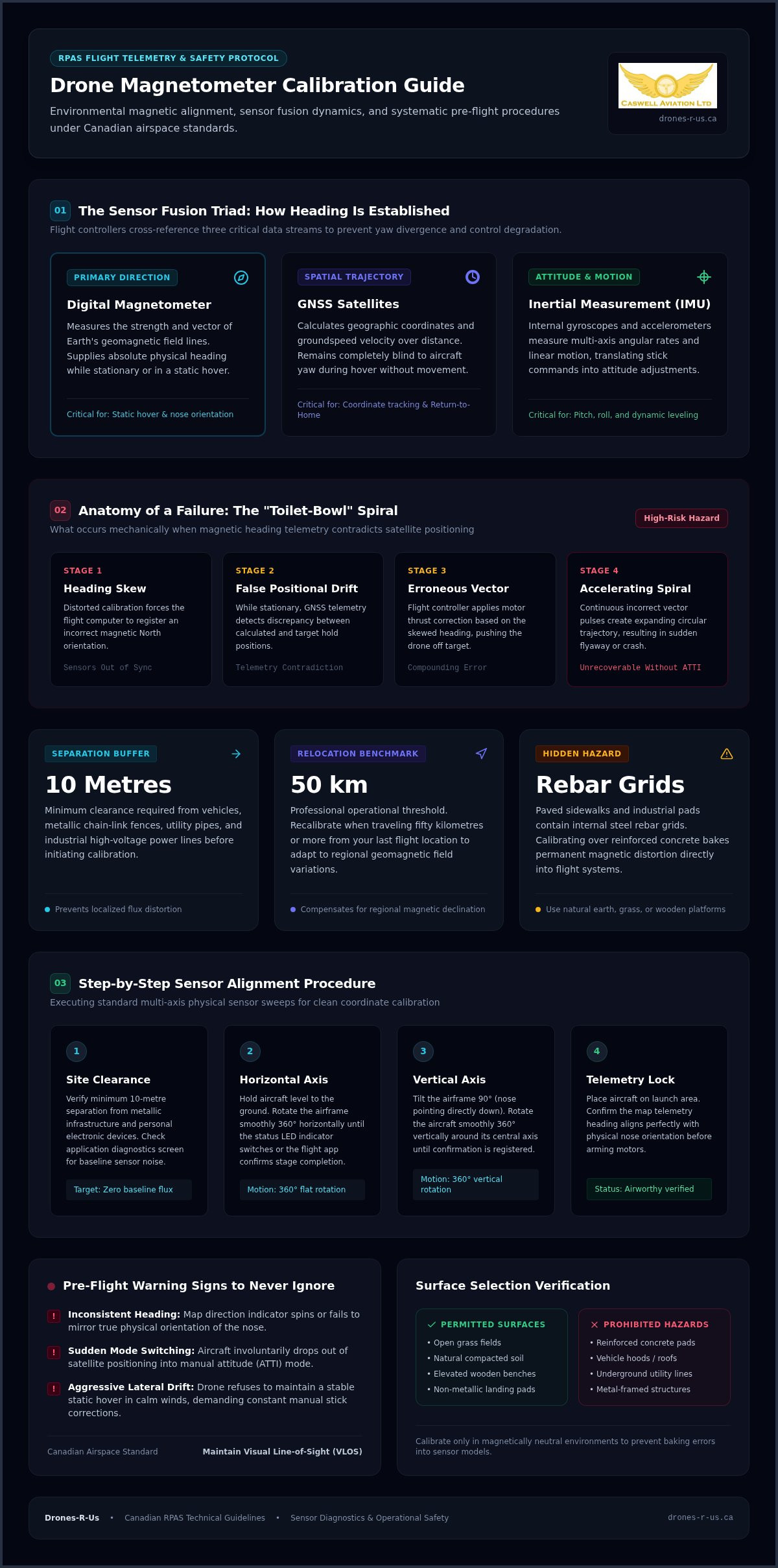
Safe remotely piloted aircraft operations rely on precise telemetry synchronization. Inside your drone sits an internal magnetometer sensor that measures the strength and direction of Earth's geomagnetic field lines. While global navigation satellite systems (GNSS) calculate geographic position and velocity over ground, they cannot determine which direction the airframe points while stationary or hovering. The digital compass supplies this vital heading data. Without continuous alignment between these systems, the flight controller cannot translate pilot stick inputs into predictable movements.
Modern flight systems use sensor fusion algorithms to merge magnetometer headings with inertial measurement unit (IMU) data from internal gyroscopes and accelerometers. When magnetic readings drift out of true alignment, this mathematical model collapses. Understanding how to calibrate a drone compass ensures your aircraft maintains precise spatial awareness, preventing severe yaw divergence and unexpected control degradation during flight.
The Role of the Digital Magnetometer in Flight
The magnetometer establishes physical heading instantaneously, allowing the drone to orient its coordinate grid against true North. While GNSS calculates trajectory by tracking changes between coordinate points during movement, it remains blind to aircraft yaw during a static hover. The flight controller cross-references both data streams constantly. If you trigger an automated Return-to-Home (RTH) failsafe, the flight computer points the nose toward the home point using compass heading while tracking groundspeed via GNSS. A compromised compass causes the aircraft to track off course immediately during emergency procedures.
Recognizing Dangerous Compass Errors Before Take-off
Flight management applications warn pilots of heading discrepancies through on-screen alerts, such as "Compass Error" or "Sensor Bias Detected." Ignoring these prompts can result in the catastrophic toilet-bowl effect, where heading telemetry contradicts satellite positioning. In this scenario, the flight controller detects an apparent positional drift and applies corrective motor thrust. Because the aircraft's internal heading is skewed, this corrective vector pushes the drone in the wrong direction, creating an accelerating spiral trajectory that frequently ends in an unrecoverable flyaway.
- Inconsistent Heading Telemetry: The map indicator spins or fails to align with the actual physical orientation of the nose.
- Sudden Mode Switching: The aircraft involuntarily drops from satellite-assisted positioning into manual attitude (ATTI) mode.
- Aggressive Lateral Drifting: The drone fails to hold a stable hover in light winds, demanding constant manual stick corrections.
Maintaining clear visual line-of-sight (VLOS) is mandatory under Canadian aviation regulations and remains your ultimate safety barrier. When sensor fusion fails, immediate manual pilot intervention is the only way to recover the aircraft safely. Mastering how to calibrate a drone compass properly eliminates this baseline risk before your props ever spin.
Pre-Calibration Checklist: Identifying Environmental Magnetic Interference
A successful calibration depends entirely on the magnetic cleanliness of your immediate environment. Because magnetometers measure subtle magnetic flux, conducting a routine near ferrous metals ruins sensor accuracy before your aircraft leaves the ground. Maintain a separation buffer of at least ten metres from vehicles, chain-link fences, and industrial power lines. Before initiating any routine, consult your flight application's sensor diagnostics screen to evaluate live magnetic interference levels. Aviation frameworks like the FAA sUAS Advisory Circular 107-2A emphasize that systematic pre-flight inspections, including verifying baseline sensor health, are vital for operational airworthiness.
Surface Selection and Hidden Subsurface Metal Hazards
Paved sidewalks, industrial launch pads, and parking structures represent the most common operational trap. These concrete structures conceal internal steel reinforcement rebar grids that emit intense localized magnetic signatures. Calibrating an aircraft directly over rebar forces the flight controller to treat that localized distortion as Earth's true geomagnetic baseline. As soon as the aircraft climbs ten feet into clean air, the localized field disappears, triggering instant sensor conflict and flight instability.
Always relocate to natural ground, such as manicured grass fields, bare soil, or wooden observation decks. If you work in regions with heavily mineralized ground or wet, iron-rich sand, elevate the aircraft using a clean, non-metallic landing pad or plastic tote to isolate the internal sensors from ground-level interference.
Pilot Gear and Smart Controller Interference Risks
Pilots frequently overlook the ferromagnetic items worn on their own bodies during pre-flight checks. Smartwatches with magnetic clasps, smartphones, handheld radios, and heavy belt buckles distort magnetometer readings when held within inches of the airframe during the calibration sequence. Set secondary equipment aside before picking up the aircraft:
- Personal Devices: Place smartphones, key fobs, and tools at least three metres away from the calibration zone.
- Wearable Metal: Remove magnetic wristbands or smart tracking accessories prior to handling the drone.
- Ground Stations: Keep heavy smart controllers resting on a neutral surface rather than pressed directly against the airframe.
Understanding how to calibrate a drone compass properly requires treating your launch environment with methodical discipline. Developing a structured pre-flight routine through online drone courses ensures pilots identify these invisible hazards routinely, protecting sensitive equipment and establishing reliable heading accuracy on every flight.
How to Calibrate a Drone Compass: Step-by-Step Procedure
Executing an accurate calibration requires steady handling and clean rotational technique. Once you have established a clear buffer from interference, power on your remote controller, mobile device, and aircraft on flat ground. Allow the flight system to complete its initial diagnostic sweep before touching the airframe. Knowing how to calibrate a drone compass properly ensures the internal flight computer logs accurate magnetic flux baselines across both axes without recording anomalous spikes.
Initiating Calibration Mode in Your Flight App
Open your flight application and enter the main settings menu. Select the safety submenu, scroll to the sensor status section, and tap into compass calibration. Verify that the aircraft battery holds at least a 50% charge before tapping the start prompt, as low voltage can cause unexpected timeouts midway through the routine. Ensure all airframe arms are completely unfolded, propeller locks are removed, and gimbal clamps are detached before proceeding.
Executing the Horizontal and Vertical Rotational Axis Turns
Lift the airframe approximately one metre off the ground, keeping it completely level. Begin rotating your body smoothly in a full 360-degree circle while holding the drone flat before you. Avoid spinning the craft rapidly in your hands; instead, turn your entire body at a moderate, consistent walking pace to maintain a stable horizontal plane.
- Horizontal Plane: Rotate 360 degrees smoothly until the rear status LEDs change from solid yellow to steady green, or until the application sounds a progress chime.
- Vertical Plane: Turn the aircraft 90 degrees so the nose points directly toward the ground (or vertical as prompted by your specific airframe interface).
- Secondary Rotation: Complete an identical 360-degree rotation around your body axis while maintaining the nose-down orientation until the screen confirms completion.
Post-Calibration Verification and Flight Confirmation
Once both rotational sweeps finish, the interface displays a clear calibration successful dialog. If the screen shows a failure alert, do not force an immediate re-run in the same spot. Relocate several metres away to rule out subterranean metallic piping or utility lines. Inspect the radar map on your primary flight display: the directional aircraft chevron must match the exact physical direction your drone faces on the pad. Power-cycle the aircraft to ensure the newly saved baseline loads cleanly into memory before spooling up the motors.
Troubleshooting Persistent Calibration Errors and Sensor Drift
Field diagnostics require a systematic process of elimination when a sensor refuses to initialize. Pilots often assume a stubborn calibration alert signals hardware failure, yet environmental anomalies or adjacent sensor conflicts cause the vast majority of field rejections. Knowing how to calibrate a drone compass under difficult conditions means isolating whether the issue stems from invisible subsoil infrastructure, physical airframe contamination, or a corrupted inertial reference frame.
Resolving Common Compass Calibration Failure Prompts
Immediate calibration failures usually point to localized underground anomalies rather than defective sensors. Buried high-voltage conduits, cast-iron municipal water mains, and buried telecommunications infrastructure create strong magnetic gradients that confuse the flight controller during rotational sampling. If an initial attempt fails, pack the craft and relocate at least fifty metres away to establish a fresh magnetic baseline on neutral terrain.
Hardware contamination also triggers repeated failures. Check the landing gear and lower airframe shell for magnetic debris. Tiny ferromagnetic particles, like iron-rich sand or fine metallic filings from transport cases, often adhere to landing pads or motor housings. In addition, allow internal flight electronics to cool down if the aircraft sat in direct sun or operated through back-to-back flights, as excessive internal heat degrades magnetometer calibration thresholds.
The Relationship Between Compass Health and IMU Calibration
Compass drift frequently masquerades as an orientation fault when the primary culprit is an uncalibrated Inertial Measurement Unit (IMU). The flight controller's sensor fusion algorithms rely on accelerometers and gyroscopes to calculate airframe attitude. When an IMU carries subtle tilt biases, the mathematical model misinterprets level flight, producing artificial heading errors on screen. Resolving this discrepancy requires a structured reset:
- Execute a Cold IMU Calibration: Power on the drone indoors on an engineered level surface while the airframe remains completely cold, allowing the gyroscopes to baseline without thermal drift.
- Cross-Check Redundant Sensors: On commercial platforms equipped with dual magnetometers, access the advanced sensor menu to see whether Compass 1 or Compass 2 is producing anomalous flux readings.
- Re-Attempt Compass Initialization: Once the IMU demonstrates zero bias, return outdoors to execute the rotational compass routine in clean air.
Mastering these diagnostic protocols is an essential operational skill for commercial operators. If you want to refine your technical troubleshooting and build real flight proficiency, explore structured in-person training designed to elevate your operational standards and emergency management skills.
Professional Best Practices: When to Calibrate and Aviation Safety
Professional remotely piloted aircraft operations demand standardized procedures rather than guesswork. A disciplined standard operating procedure (SOP) treats sensor alignment as an intentional maintenance event rather than a nervous pre-flight ritual. Knowing how to calibrate a drone compass correctly involves understanding the geographic thresholds that alter magnetic environments, as well as recognizing when leaving your sensors untouched is the safer aeronautical decision.
Determining Necessary Frequency Versus Unnecessary Calibration
Recalibrating your compass before every single flight is unnecessary and often introduces operational hazards. If your control interface displays healthy green sensor diagnostics on clean ground, forcing a routine risks capturing transient surface distortion and baking it into your flight controller. Reserve active calibration for specific operational triggers:
- Geographic Relocation: Calibrate whenever your flight site changes by more than fifty kilometres from the last operating location to adjust for shifts in regional geomagnetic inclination and declination.
- Hardware Reconfigurations: Recalibrate after mounting third-party accessories, enterprise payload sensors, or new landing gear extensions that subtly change the airframe's magnetic signature.
- Firmware and Long Storage: Complete a fresh routine following major flight controller firmware updates or extended periods of storage in magnetic proximity to vehicle alternators or storage lockers.
- Direct System Prompts: Execute the procedure when the flight management software explicitly requires it after booting on clean, verified ground.
Transport Canada Flight Safety Standards and Risk Mitigation
Transport Canada regulations require every remote pilot to verify aircraft airworthiness prior to takeoff. Sensor verification forms a core pillar of legal site surveys and pre-flight checklists under the Canadian Aviation Regulations. Logging your sensor health checks and recording compass calibrations in your maintenance documentation establishes an auditable record of diligent risk mitigation.
Pilots who treat instrument management casually expose themselves and the public to preventable flyaways and costly equipment loss. Mastering the practical nuances of sensor telemetry, site selection, and failsafe behaviour separates casual hobbyists from certified commercial operators. Building genuine competence starts with comprehensive professional flight review curriculum standards and Transport Canada compliant training frameworks through structured online drone courses, giving you complete confidence across every operational environment.
Elevate Your Operational Standards and Navigational Precision
Mastering how to calibrate a drone compass transforms an anxious pre-flight guess into a disciplined, repeatable aeronautical standard. By actively inspecting your launch site for concealed ferromagnetic interference, executing smooth multi-axis rotations, and recognising when leaving healthy sensors alone is the safer choice, you protect your aircraft against hazardous sensor divergence and toilet-bowling drift.
Methodical pre-flight preparation remains the defining hallmark of a professional pilot. If you are ready to expand your technical competence and eliminate preventable operational errors, master professional pre-flight safety with certified drone training. Caswell Aviation Ltd provides comprehensive coursework backed by a Transport Canada compliant curriculum, connecting you with experienced aviation instructors with nationwide training experience. From foundational flight principles to complex advanced operations, build the disciplined habits required to fly every mission with absolute confidence.
Frequently Asked Questions
How often do I really need to calibrate my drone compass?
You should only calibrate when moving more than fifty kilometres from your last flight site, after installing hardware modifications, or when prompted by the flight app on clean ground. Routine daily recalibrations are unnecessary and actually increase operational risk. If your system indicators show healthy green telemetry, forcing a calibration can bake localized magnetic distortions into your flight controller.
Why does my drone compass calibration keep failing in an open field?
Open fields often hide subterranean metal infrastructure such as agricultural drainage pipes, buried utility cables, or high concentrations of iron-bearing minerals. Personal accessories like smartwatches, smartphones, or magnetic tool clips held near the craft will also disrupt sampling. If an initial attempt fails, move fifty metres to a new area and ensure all personal electronics remain at a distance.
Can I calibrate my drone compass on a concrete driveway or sidewalk?
Never calibrate an aircraft on concrete driveways, sidewalks, or paved roadways. Poured concrete is reinforced with steel rebar grids that generate intense localized magnetic fields. Calibrating over rebar programs that distortion as the aircraft's neutral baseline. As soon as you ascend above the surface field, the flight controller encounters severe sensor conflict that can trigger sudden drift.
What is the difference between an IMU calibration and a compass calibration?
An IMU calibration aligns internal accelerometers and gyroscopes with the pull of gravity, measuring pitch, roll, and angular velocity while resting completely motionless on a level surface. A compass calibration configures the digital magnetometer against Earth's geomagnetic field lines by rotating the aircraft through 360-degree horizontal and vertical planes. Both systems work together through sensor fusion to ensure directional flight stability.
What should I do if my drone displays a compass error while flying?
Switch immediately to manual attitude (ATTI) mode if your aircraft allows it, keep your eyes on the physical airframe, and navigate home manually using visual line of sight. Avoid engaging automated Return-to-Home, because a corrupted compass causes the flight computer to miscalculate heading vectors and drift in an expanding spiral. Land smoothly in an open zone and power-cycle the aircraft before investigating.
Do I need to calibrate the compass after updating my drone firmware?
Yes, executing a clean sensor routine after major firmware updates is a sound operational practice. Major firmware revisions frequently refresh internal sensor bus parameters and flight controller algorithms, which can reset or shift factory calibration baselines. Learning how to calibrate a drone compass on neutral ground following an installation ensures that the updated flight software reads fresh, accurate magnetic coordinates.
Does changing the drone battery require a new compass calibration?
Swapping a flight battery does not require a new calibration under normal operating conditions. Internal magnetometer profiles remain saved within the flight controller's non-volatile memory across simple power cycles. As long as you remain at the same operational location and your telemetry shows green sensor status on startup, you can insert a fresh battery and fly without re-running the rotational procedure.
Leave a comment